• Skip to main content
  • Skip to secondary menu
  • Skip to primary sidebar
  • Skip to secondary sidebar
  • Skip to footer
  • DroneRacingLife
  • DroneFlyers
  • Newsletter
DroneLife

DRONELIFE

Stay up to date on all the latest Drone News

  • News
  • Products
  • Industries
    • Agriculture
    • Construction
    • Delivery
    • Dual Use
    • Inspection
    • Public Safety
    • Surveying
  • Enthusiasts
  • Regulations
  • Business
  • Video
  • Podcasts

FOXTECH: Providing Cost-Effective Solutions for Enterprise Drone Mapping Missions

July 20, 2018 by Sponsored Post 4 Comments

Foxtech is one of China’s largest online sources for industrial multicopters, fixed -wing and VTOL products.  These commercial-grade drones are suitable for surveying, mapping, power line inspection and a wide variety of other commercial applications.   The NIMBUS VTOL Mapping Version is one of their newest offerings: a best-selling and cost-effective drone for mapping and surveying.

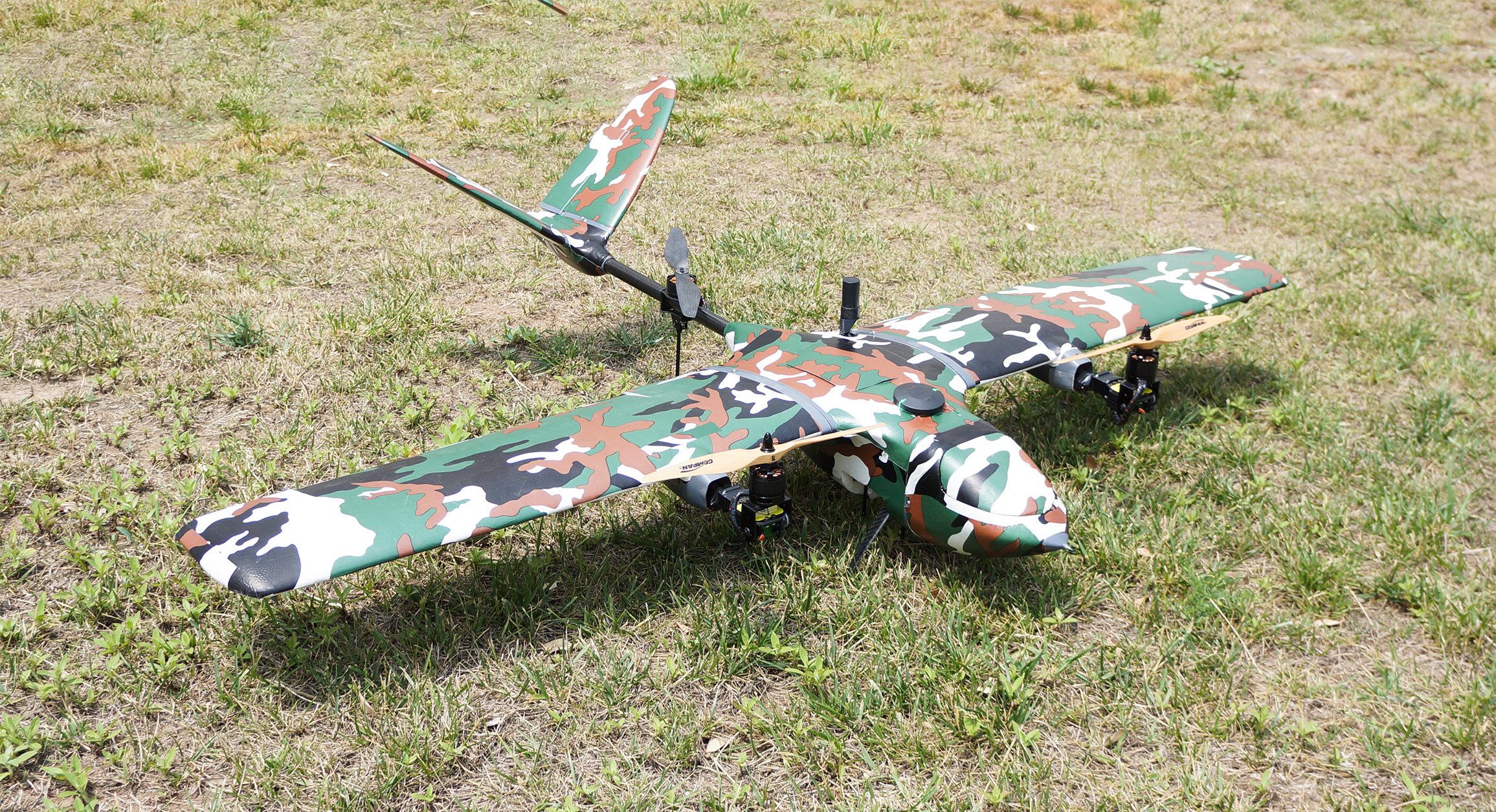
The NIMBUS VTOL a Tri-copter VTOL with vector Yaw features great power redundancy, and can lift 500g  – more than a pound – easily. The max flying speed is up to 35m/s, and with one 6S 10000mAh lipo battery, flight duration is approximately 1 hour including take-off and landing. Nimbus VTOL features good system security, and can switch to multicopter mode to save the plane and land safely in case of failure.  The drone can launch directly from an area as small as 3x3m. With a suitable speed and up to a 60-minute endurance, NIMBUS VTOL is capable of covering broad areas that other drones of the same size cannot, saving clients significant time.

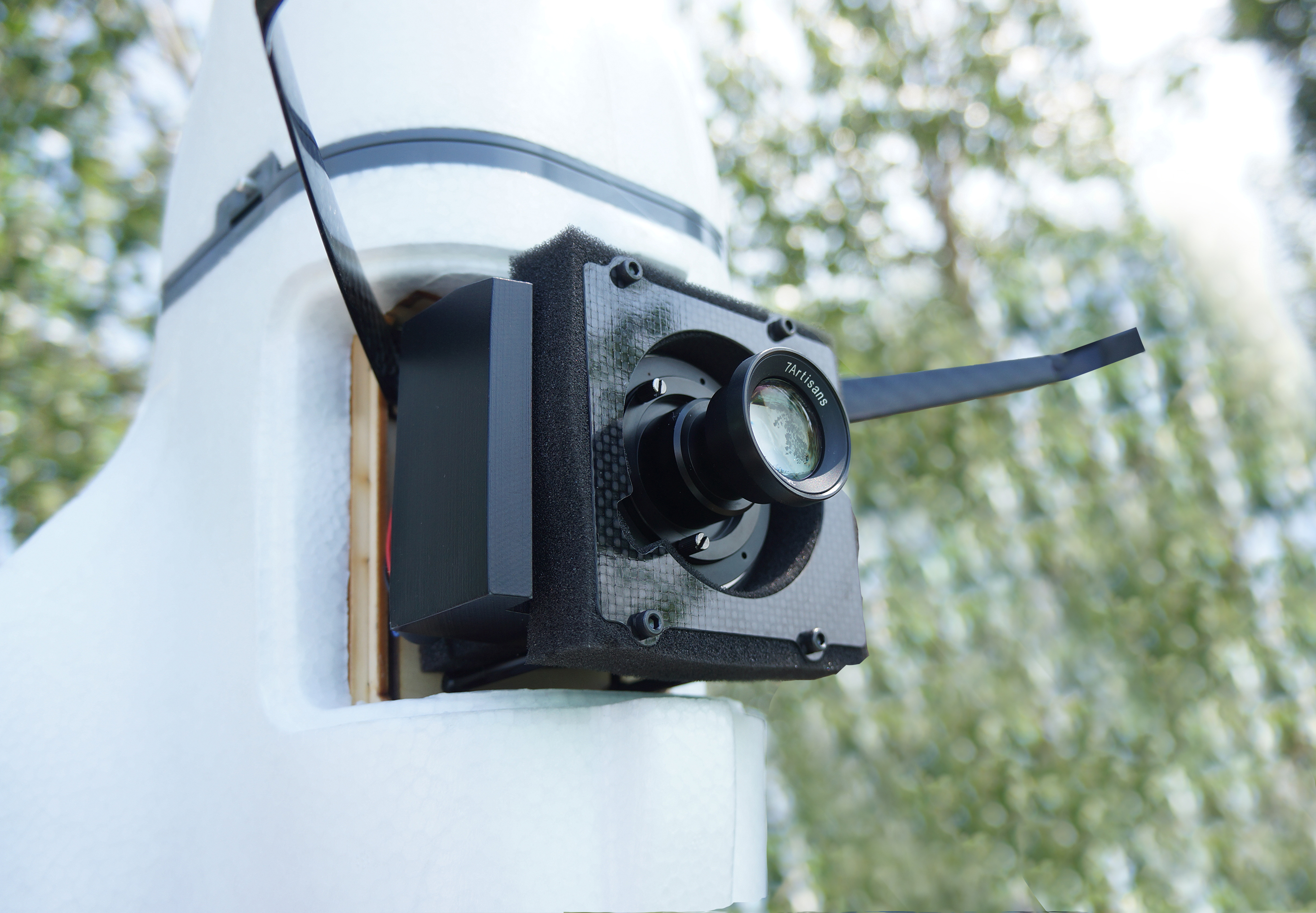
For mapping applications, FOXTECH Map-01 and Map-A7R mapping cameras are good options for higher-quality mapping and survey missions. Whether for inspection or for map-making, the combination of Nimbus VTOL and Map-01 or Map-A7R camera offers an impressive solution for UAV surveying.

Foxtech Map-01 is an interchangeable lens camera with APS-C sensor and 24.3 MP pixels, which is very small and light, only 155g. The camera’s lens can change easily to meet your needs: the compatible lens are E35mm F1.8, E20mm F2.8, E16mm F2.8 and more. Foxtech Map-A7R is a 35mm full-frame interchangeable-lens camera with 42 megapixels. And, the Map-A7R can save 30% more photos compared with Map-01, covering the same operation area.

Foxtech Map-01 camera and Foxtech Map-A7R can be easily integrated into many different UAVS and small aircraft because of the light weight and small size. The mapping cameras also could be connected with PPK&RTK system to ensure a centimeter-level accuracy  aerial survey through a trigger switch signal. After the flight, an accurate photogrammetric model will be generated by software like Pix4D, Smart3D or Photoscan.

The Nimbus VTOL Mapping Version can go waypoints & click-go automatically in either fixed wing or multicopter mode by changing settings in the ground station. The newly released Foxtech GS01 Ground Station integrated transmitter, receiver and Windows system gives the pilot full control over the drone, while allowing auto flight programming.

GS01 handheld ground station can realize real-time flight status and control status feedback, also waypoint planning function etc. Real-time telemetry data can be displayed on the screen during flight including flight mode, altitude, speed over ground, distance from home, GPS position coordinates, and aircraft battery status. The GS01 handheld ground station equipped with Windows systems supports most of the ground station software, like pixhawk and AheadX.  An industrial-grade computer and military-grade transmission link will ensure the security and stability of your drones.
Foxtech Nimbus 1800 VTOL mapping version coupled with Foxtech Mapping camera and GS01 Ground Station is a high-quality and cost-effective mapping combo –  a good option for clients to perform precision mapping jobs.

Filed Under: Agriculture, Chemical, Construction, Uncategorized Tagged With: mapping drones, VTOL drones

Reader Interactions

Trackbacks

  1. Vigilant Provides Detect-and-Avoid for Medical Drone Delivery - Tech Center Guam UAS says:
    May 1, 2020 at 12:11 pm

    […] Nimbus VTOL V2 drone carries a medical supply payload delivery container and can deliver items like virus testing […]

    Reply
  2. Vigilant Provides Detect-and-Avoid for Medical Drone Delivery | Aerial Division says:
    May 1, 2020 at 11:06 am

    […] Nimbus VTOL V2 drone carries a medical supply payload delivery container and can deliver items like virus testing […]

    Reply
  3. Vigilant Provides Detect-and-Avoid for Medical Drone Delivery | Gadgets says:
    April 30, 2020 at 1:47 pm

    […] Nimbus VTOL V2 drone carries a medical supply payload delivery container and can deliver items like virus testing […]

    Reply
  4. FOXTECH: Providing Cost-Effective Solutions for Enterprise Drone Mapping Missions | News and Reviews about Drones, Quadcopter, Camera says:
    July 22, 2018 at 5:34 am

    […] Source link […]

    Reply

Leave a Reply Cancel reply

Your email address will not be published. Required fields are marked *

Primary Sidebar

LATEST

XTEND and ParaZero Partner to Deliver Autonomous Drone Interception System

New integration combines AI-powered drone platform with net-based capture system for counter-UAS missions JFB Construction Holdings and XTEND have announced…

Continue Reading XTEND and ParaZero Partner to Deliver Autonomous Drone Interception System

EU Fast-Tracks €115M Defense Innovation Fund to Accelerate Drone and AI Deployment

EU to earmark €115 million for AI, drone innovation By DRONELIFE Features Editor Jim Magill The governing body of the…

Continue Reading EU Fast-Tracks €115M Defense Innovation Fund to Accelerate Drone and AI Deployment

DeTect Reorganizes into Three Global Regions to Support Growth

New leadership structure aims to strengthen global operations and customer support DeTect, Inc. has announced a new organizational structure designed…

Continue Reading DeTect Reorganizes into Three Global Regions to Support Growth

Barksdale Drone Incursions Highlight Real Security Risks

Confirmed incursions at a strategic U.S. bomber base highlight real risk A Week of Drone Incursions at a Strategic Base…

Continue Reading Barksdale Drone Incursions Highlight Real Security Risks

Blue Innovation Deploys Drones for Nighttime Wildfire Imaging in Japan

This article published in collaboration with JUIDA, the Japan UAS Industrial Development Association.     Blue Innovation Co., Ltd. deployed drones…

Continue Reading Blue Innovation Deploys Drones for Nighttime Wildfire Imaging in Japan

University of Kentucky Researcher Wins NSF Award for Drone Fleet Safety Research

A University of Kentucky researcher has received a National Science Foundation (NSF) CAREER Award worth $534,264 over five years to develop safer…

Continue Reading University of Kentucky Researcher Wins NSF Award for Drone Fleet Safety Research

Canada Bets Big on Sovereign Drone Power with New National Innovation Hub

Canada to establish Drone Innovation Hub By DRONELIFE Features Editor Jim Magill Canada, which has become a world leader in…

Continue Reading Canada Bets Big on Sovereign Drone Power with New National Innovation Hub

Drones Support World-First Mouse Eradication Project on Remote Australian Island

Aerial baiting effort aims to restore seabird populations and fragile ecosystems A remote island off the coast of Western Australia…

Continue Reading Drones Support World-First Mouse Eradication Project on Remote Australian Island

Who Gets to Fly? ACLU Paper Examines the Future of Drone Access

Access, Regulation, and the Future of Drone Use Analysis raises questions about how policy decisions may shape who benefits from…

Continue Reading Who Gets to Fly? ACLU Paper Examines the Future of Drone Access

New DJI Avata 360 Brings 8K 360-Degree FPV Flying to Creators

DJI today launched the DJI Avata 360, a new 8K 360-degree FPV drone built for immersive aerial content creation. The…

Continue Reading New DJI Avata 360 Brings 8K 360-Degree FPV Flying to Creators

Secondary Sidebar

Footer

SPONSORED

Inspired Flight Gremsy IF800 VIO F1 drones geo week

What Will It Take to Strengthen U.S. Drone Manufacturing? A Conversation with Inspired Flight’s CEO

Global Mapper Mobile data collection

Collection Ground Control Points with Global Mapper Mobile

Military Drone Mapping Solutions

How SimActive’s Correlator3D™ is Revolutionizing Military Mapping: An Exclusive Interview with CEO Philippe Simard

Photogrammetry Accuracy Standards

SimActive Photogrammetry Software: Enabling Users to Meet Accuracy Standards for Over 20 Years

NACT Engineering Parrot ANAFI tether indoor shot

Smart Tether for Parrot ANAFI USA from NACT Engineering

Blue Marble, features global mapper, features Blue Marble

Check Out These New Features in Global Mapper v25 from Blue Marble

About Us | Contact Us | Advertise With Us | Write for Us | Privacy Policy | Terms of Service

The Trusted Source for the Business of Drones.

This website uses cookies and third party services. By clicking OK, you are agreeing to our privacy policy. ACCEPT

Manage consent

Privacy Overview

This website uses cookies to improve your experience while you navigate through the website. Out of these, the cookies that are categorized as necessary are stored on your browser as they are essential for the working of basic functionalities of the website. We also use third-party cookies that help us analyze and understand how you use this website. These cookies will be stored in your browser only with your consent. You also have the option to opt-out of these cookies. But opting out of some of these cookies may affect your browsing experience.
Necessary
Always Enabled
Necessary cookies are absolutely essential for the website to function properly. These cookies ensure basic functionalities and security features of the website, anonymously.
CookieDurationDescription
cookielawinfo-checkbox-analytics11 monthsThis cookie is set by GDPR Cookie Consent plugin. The cookie is used to store the user consent for the cookies in the category "Analytics".
cookielawinfo-checkbox-functional11 monthsThe cookie is set by GDPR cookie consent to record the user consent for the cookies in the category "Functional".
cookielawinfo-checkbox-necessary11 monthsThis cookie is set by GDPR Cookie Consent plugin. The cookies is used to store the user consent for the cookies in the category "Necessary".
cookielawinfo-checkbox-others11 monthsThis cookie is set by GDPR Cookie Consent plugin. The cookie is used to store the user consent for the cookies in the category "Other.
cookielawinfo-checkbox-performance11 monthsThis cookie is set by GDPR Cookie Consent plugin. The cookie is used to store the user consent for the cookies in the category "Performance".
viewed_cookie_policy11 monthsThe cookie is set by the GDPR Cookie Consent plugin and is used to store whether or not user has consented to the use of cookies. It does not store any personal data.
Functional
Functional cookies help to perform certain functionalities like sharing the content of the website on social media platforms, collect feedbacks, and other third-party features.
Performance
Performance cookies are used to understand and analyze the key performance indexes of the website which helps in delivering a better user experience for the visitors.
Analytics
Analytical cookies are used to understand how visitors interact with the website. These cookies help provide information on metrics the number of visitors, bounce rate, traffic source, etc.
Advertisement
Advertisement cookies are used to provide visitors with relevant ads and marketing campaigns. These cookies track visitors across websites and collect information to provide customized ads.
Others
Other uncategorized cookies are those that are being analyzed and have not been classified into a category as yet.
SAVE & ACCEPT