• Skip to main content
  • Skip to secondary menu
  • Skip to primary sidebar
  • Skip to secondary sidebar
  • Skip to footer
  • DroneRacingLife
  • DroneFlyers
  • Newsletter
DroneLife

DRONELIFE

Stay up to date on all the latest Drone News

  • News
  • Products
  • Industries
    • Agriculture
    • Construction
    • Delivery
    • Dual Use
    • Inspection
    • Public Safety
    • Surveying
  • Enthusiasts
  • Regulations
  • Business
  • Video
  • Podcasts

Terra Drone Announces New Image Processing Software, “Terra Mapper” to Commercial Market

August 28, 2017 by Frank Schroth 8 Comments

Terra Mapper

Terra Drone Co., Ltd. headquartered in Shibuya-ku, Tokyo, have launched their image processing software “Terra Mapper” designed to assist drone surveying services. Terra Mapper is an automated drone navigation, image processing, and 3D image analysis program that is available in both cloud and desktop versions. It enables users to accurately inspect the 2D & 3D data images produced by their nominated drone service, allowing effective analysis at a more cost-efficient price.

Key features of Terra Mapper Cloud include:

  • For all data processing and management, the software does not have to be installed on a desktop. Access to the internet on PC, tablet, smart phones or other devices will have your organization immediately connected.
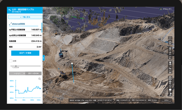
  • In Terra Mapper Cloud, we offer construction management tools to monitor the numerical change in components such as soil volumes and elevation levels at the site. The data is also readily available, so they be used as reference materials on and off the site.
  • Terra Mapper Cloud is a platform for sharing information between project members. In addition sharing information and incorporating a chat function, you can also delegate tasks, allocate the placement of equipment and monitor the progress of the site.


Terra Mapper Desktop key features

  • By automatically recognizing anti-aircraft sign, time can be spent on obtaining more accurate data.
  • More accurate topographical data can be measured by displaying and automatically eliminating the unnecessary components on site including construction equipment and foliage in the field. Ultimately allowing an accurate detection of soil to be removed, the amount of soil and cross sections of the land.
  • Creates cross sectional diagrams simply while evenly spacing with the center line of the figure.
  • To simplify the calculation of embankments and cutting and also TIN Surface (Triangulated irregular network) It is possible to create one.

Pricing, availability, and which drones the software is compatible were not released. An update will be posted when and if that information becomes available. You can learn more about the company and its products here.

Frank Schroth
Frank Schroth

Frank Schroth is editor in chief of DroneLife, the authoritative source for news and analysis on the drone industry: it’s people, products, trends, and events.
Email Frank
TWITTER:@fschroth

Filed Under: Drone News Feeds, News, Products Tagged With: Drone Software, Surveying, Terr Mapper

Reader Interactions

Trackbacks

  1. Terra Drone Expands Market After Australian Data Firm Acquisition | News and Reviews about Drones, Quadcopter, Camera says:
    December 11, 2018 at 1:01 am

    […] year, Terra Drone launched new image processing software Terra Mapper to optimize drone surveying services. The platform is an automated drone navigation, image […]

    Reply
  2. Terra Drone Expands Market After Australian Data Firm Acquisition - Drones Crunch says:
    December 10, 2018 at 10:32 pm

    […] year, Terra Drone launched new image processing software Terra Mapper to optimize drone surveying services. The platform is an automated drone navigation, image […]

    Reply
  3. Terra Drone Expands Market After Australian Data Firm Acquisition - Droneoo says:
    December 10, 2018 at 7:52 pm

    […] year, Terra Drone launched new image processing software Terra Mapper to optimize drone surveying services. The platform is an automated drone navigation, image […]

    Reply
  4. Drones provide a depressing look at Hurricane Harvey's devastation | Drone "Ki" says:
    September 28, 2017 at 1:06 am

    […] Terra Drone Co., Ltd. headquartered in Shibuya-ku, Tokyo, have launched their image processing software “Terra Mapper” designed to assist drone surveying services. Terra Mapper is an automated drone navigation, image processing, and 3D image analysis program that is available in both cloud and desktop versions. It enables users to accurately inspect the 2D & 3D […] The post Terra Drone Announces New Image Processing Software, “Terra Mapper” to Commercial Market appeared first on DRONELSee Original Article […]

    Reply
  5. Terra Drone Announces New Image Processing Software, “Terra Mapper” to Commercial Market « Best FPV Quadcopters Under 100 USD says:
    August 28, 2017 at 1:03 pm

    […] post Terra Drone Announces New Image Processing Software, “Terra Mapper” to Commercial Market appeared first on […]

    Reply
  6. Terra Drone Announces New Image Processing Software, “Terra Mapper” to Commercial Market - Tec Ofertas UK says:
    August 28, 2017 at 10:48 am

    […] post Terra Drone Announces New Image Processing Software, “Terra Mapper” to Commercial Market appeared first on […]

    Reply
  7. Terra Drone Announces New Image Processing Software, “Terra Mapper” to Commercial Market – TheDrones.Link says:
    August 28, 2017 at 10:10 am

    […] post Terra Drone Announces New Image Processing Software, “Terra Mapper” to Commercial Market appeared first on […]

    Reply
  8. Terra Drone Announces New Image Processing Software, “Terra Mapper” to Commercial Market – Dronegram says:
    August 28, 2017 at 10:07 am

    […] post Terra Drone Announces New Image Processing Software, “Terra Mapper” to Commercial Market appeared first on […]

    Reply

Leave a Reply Cancel reply

Your email address will not be published. Required fields are marked *

Primary Sidebar

LATEST

Teledyne FLIR OEM Upgrades Prism SKR Software for Autonomous Target Recognition

New release combines mission execution and intelligent supervision in a single autonomy platform Teledyne FLIR OEM has announced an upgrade…

Continue Reading Teledyne FLIR OEM Upgrades Prism SKR Software for Autonomous Target Recognition

Drone Operations Software Company AirHub Closes €4.4M Series A

AirHub, a European drone operations software company based in The Hague, has closed a €4.4 million Series A funding round.…

Continue Reading Drone Operations Software Company AirHub Closes €4.4M Series A

Arrive AI Patents Shared Drone Delivery Endpoint With Tenth U.S. Patent

Arrive AI (NASDAQ: ARAI) has secured its tenth U.S. patent, strengthening its intellectual property portfolio for autonomous drone delivery infrastructure.…

Continue Reading Arrive AI Patents Shared Drone Delivery Endpoint With Tenth U.S. Patent

Korean eVTOL Developer Airbility Partners on UAV Public Safety in Thailand

South Korean eVTOL developer Airbility has signed a four-party Memorandum of Understanding to deploy UAV systems for public safety and…

Continue Reading Korean eVTOL Developer Airbility Partners on UAV Public Safety in Thailand

Is U.S. Manufacturing the Answer? SKYROVER Signals a New Strategy as FCC Pressure Mounts

A Hong Kong-based drone company outlines a five-year U.S. roadmap, raising questions about compliance, supply chains, and market access A…

Continue Reading Is U.S. Manufacturing the Answer? SKYROVER Signals a New Strategy as FCC Pressure Mounts

Blue Marble Geographics and Avenza Systems Combine to Create Unified Geospatial Platform

Merger connects office-based analysis with field operations for end-to-end spatial workflows Blue Marble Geographics and Avenza Systems, Inc. have announced…

Continue Reading Blue Marble Geographics and Avenza Systems Combine to Create Unified Geospatial Platform

Amazon Prime Air Adjusts Course After Richardson Setbacks

After rocky start in Texas city, Amazon Air service flying high By DRONELIFE Features Editor Jim Magill After only a…

Continue Reading Amazon Prime Air Adjusts Course After Richardson Setbacks

Airspace Security at 2026 JUNO Awards

RF-Cyber counter-drone system enables non-disruptive protection for large public event D-Fend Solutions announced that its EnforceAir counter-drone system was deployed…

Continue Reading Airspace Security at 2026 JUNO Awards

Will States Be Ready with Counter Drone Tech for the FIFA World Cup?

Funding snafu, other issues delay counter-UAS ramp-up in Maryland, elsewhere By DRONELIFE Features Editor Jim Magill (Editor’s note: This is…

Continue Reading Will States Be Ready with Counter Drone Tech for the FIFA World Cup?

Strait of Hormuz Tensions Highlight a Growing Role for Small Drone Surveillance

Maritime risk, insurance pressure, and degraded navigation signals point to new use cases for commercial UAV systems Ongoing tension in…

Continue Reading Strait of Hormuz Tensions Highlight a Growing Role for Small Drone Surveillance

Secondary Sidebar

Footer

SPONSORED

Inspired Flight Gremsy IF800 VIO F1 drones geo week

What Will It Take to Strengthen U.S. Drone Manufacturing? A Conversation with Inspired Flight’s CEO

Global Mapper Mobile data collection

Collection Ground Control Points with Global Mapper Mobile

Military Drone Mapping Solutions

How SimActive’s Correlator3D™ is Revolutionizing Military Mapping: An Exclusive Interview with CEO Philippe Simard

Photogrammetry Accuracy Standards

SimActive Photogrammetry Software: Enabling Users to Meet Accuracy Standards for Over 20 Years

NACT Engineering Parrot ANAFI tether indoor shot

Smart Tether for Parrot ANAFI USA from NACT Engineering

Blue Marble, features global mapper, features Blue Marble

Check Out These New Features in Global Mapper v25 from Blue Marble

About Us | Contact Us | Advertise With Us | Write for Us | Privacy Policy | Terms of Service

The Trusted Source for the Business of Drones.

This website uses cookies and third party services. By clicking OK, you are agreeing to our privacy policy. ACCEPT

Manage consent

Privacy Overview

This website uses cookies to improve your experience while you navigate through the website. Out of these, the cookies that are categorized as necessary are stored on your browser as they are essential for the working of basic functionalities of the website. We also use third-party cookies that help us analyze and understand how you use this website. These cookies will be stored in your browser only with your consent. You also have the option to opt-out of these cookies. But opting out of some of these cookies may affect your browsing experience.
Necessary
Always Enabled
Necessary cookies are absolutely essential for the website to function properly. These cookies ensure basic functionalities and security features of the website, anonymously.
CookieDurationDescription
cookielawinfo-checkbox-analytics11 monthsThis cookie is set by GDPR Cookie Consent plugin. The cookie is used to store the user consent for the cookies in the category "Analytics".
cookielawinfo-checkbox-functional11 monthsThe cookie is set by GDPR cookie consent to record the user consent for the cookies in the category "Functional".
cookielawinfo-checkbox-necessary11 monthsThis cookie is set by GDPR Cookie Consent plugin. The cookies is used to store the user consent for the cookies in the category "Necessary".
cookielawinfo-checkbox-others11 monthsThis cookie is set by GDPR Cookie Consent plugin. The cookie is used to store the user consent for the cookies in the category "Other.
cookielawinfo-checkbox-performance11 monthsThis cookie is set by GDPR Cookie Consent plugin. The cookie is used to store the user consent for the cookies in the category "Performance".
viewed_cookie_policy11 monthsThe cookie is set by the GDPR Cookie Consent plugin and is used to store whether or not user has consented to the use of cookies. It does not store any personal data.
Functional
Functional cookies help to perform certain functionalities like sharing the content of the website on social media platforms, collect feedbacks, and other third-party features.
Performance
Performance cookies are used to understand and analyze the key performance indexes of the website which helps in delivering a better user experience for the visitors.
Analytics
Analytical cookies are used to understand how visitors interact with the website. These cookies help provide information on metrics the number of visitors, bounce rate, traffic source, etc.
Advertisement
Advertisement cookies are used to provide visitors with relevant ads and marketing campaigns. These cookies track visitors across websites and collect information to provide customized ads.
Others
Other uncategorized cookies are those that are being analyzed and have not been classified into a category as yet.
SAVE & ACCEPT