• Skip to main content
  • Skip to secondary menu
  • Skip to primary sidebar
  • Skip to secondary sidebar
  • Skip to footer
  • DroneRacingLife
  • DroneFlyers
  • Newsletter
DroneLife

DRONELIFE

Stay up to date on all the latest Drone News

  • News
  • Products
  • Industries
    • Agriculture
    • Construction
    • Delivery
    • Dual Use
    • Inspection
    • Public Safety
    • Surveying
  • Enthusiasts
  • Regulations
  • Business
  • Video
  • Podcasts

Drones For Good: DJI and DroneSAR Deliver Search and Rescue App

November 9, 2016 by Miriam McNabb 2 Comments

dronesar-screenshot-1Search and rescue operations are one of drones’ great contributions to the world – allowing teams to save lives in a way that is faster, cheaper, and better than a ground search.  It’s even an area where many recreational pilots lend a hand, volunteering with local law enforcement agencies.  Now, search and rescue with drones has gotten even better: DJI, the world’s leading maker of unmanned aerial vehicles, and DroneSAR, the Irish tech start-up specializing in search and rescue, have announced a new app that integrates drone footage into incident management software.

“DroneSAR can stream live images and video, from a regular or thermal imaging camera, to an incident command center as well as other rescue teams on the ground,” says DJI’s statement. “The software can tag the GPS coordinates of a victim and automatically transmit them by email or SMS, enabling ground crews to reach victims more quickly. Completed search patterns are all recorded and logged for easy handover to oncoming rescue crews.”

DroneSAR allows rescue management teams to use drones methodically, organizing the process of data collection and allowing rescuers to manage and analyze the aerial data.  “The app takes into account various types of terrain, allowing the drone to fly patterns to survey an dronesar-screenshot-2
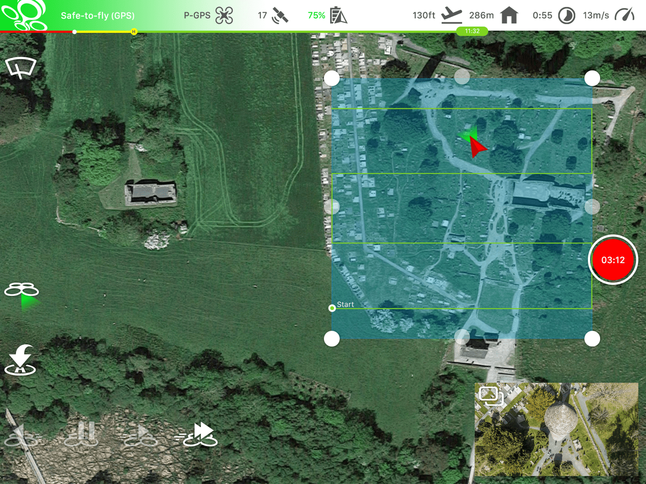
area faster and more effectively. Flight paths can be adjusted for any terrain including hills, mountains, trees or flat land,” says the DJI announcement. Drone operators could choose an aerial search pattern based on variables like altitude, field of view, battery life and probability of detection.

“From understanding on how to use the technology, to communicating findings and data, to figuring out the most appropriate tactical approach, first responders can benefit greatly from this software app on our DJI hardware,” said Romeo Durscher, Director of Education at DJI. “Many of the tasks and strategies deployed during a search and rescue operation can get sped up with automation, helping to reduce the time it takes to find a victim and save lives.”

The first-of-its-kind software was developed based on research done by DJI in conjunction with the European Emergency Number Association and Ireland’s Donegal Mountain Search and Rescue team. The groups found that while a five-person rescue team on foot needs an average of two hours to find a victim in one square kilometer, a drone can do the job in 20 minutes or less while taking additional active steps to achieve a successful rescue.

“Our aim is to save lives,” said Oisin McGrath, Co-Founder and CEO of DroneSAR. “Our software will reduce risk to search teams and reduce search time. If we can save just one life, that is mission success for us at DroneSAR.”


Miriam McNabb

Miriam McNabb is the Editor-in-Chief of DRONELIFE and CEO of JobForDrones, a professional drone services marketplace, and a fascinated observer of the emerging drone industry and the regulatory environment for drones. Miriam has penned over 3,000 articles focused on the commercial drone space and is an international speaker and recognized figure in the industry.  Miriam has a degree from the University of Chicago and over 20 years of experience in high tech sales and marketing for new technologies.
For drone industry consulting or writing, Email Miriam.

TWITTER:@spaldingbarker

Subscribe to DroneLife here.

Filed Under: News Tagged With: DJI, Drones For Good, DroneSAR, Oisin McGrath, Romeo Durscher, Search and Rescue

Reader Interactions

Trackbacks

  1. quadcopter | This Drone Can Remotely Measure Human Vital Signs says:
    September 29, 2017 at 11:08 am

    […] Read more: Drones For Good: DJI and DroneSAR Deliver Search and Rescue App […]

    Reply
  2. This Drone Can Remotely Measure Human Vital Signs | DRONEPETS.ORG says:
    September 28, 2017 at 9:09 pm

    […] Read more: Drones For Good: DJI and DroneSAR Deliver Search and Rescue App […]

    Reply

Leave a Reply Cancel reply

Your email address will not be published. Required fields are marked *

Primary Sidebar

LATEST

Taiwan’s Green UAS Milestone Highlights a Potential Path for Trusted Foreign Drone Suppliers

New assessment partnership could help allied manufacturers access the U.S. market while supporting trusted supply chain goals As the United…

Continue Reading Taiwan’s Green UAS Milestone Highlights a Potential Path for Trusted Foreign Drone Suppliers

The Future of Security: Titan Protection on the Drone Radio Show!

How Titan Protection Is Scaling Drone Operations, on this episode of the Drone Radio Show! Ryan Smith speaks with host…

Continue Reading The Future of Security: Titan Protection on the Drone Radio Show!

Latest DPA Action Highlights Manufacturing Challenge Behind U.S. Drone Expansion

New presidential memorandum focuses on defense production bottlenecks, underscoring broader questions about America’s ability to scale emerging technologies Much of…

Continue Reading Latest DPA Action Highlights Manufacturing Challenge Behind U.S. Drone Expansion

FCC Creates New Toy Drone Exemption While Defining a Low-Risk UAS Category

New FCC action removes certain toy drones from the Covered List and outlines the characteristics federal officials consider low risk.…

Continue Reading FCC Creates New Toy Drone Exemption While Defining a Low-Risk UAS Category

AirData Marks Energy and Utility Growth Milestone as BVLOS Rule Nears

The El Dorado Hills company says it now serves more than 120 energy and utility organizations globally and has logged…

Continue Reading AirData Marks Energy and Utility Growth Milestone as BVLOS Rule Nears

First DroneShield Products Roll Off Production Line in Europe

By Dronelife Features Editor Jim Magill Faced with growing challenges posed by drones flown by malicious actors, Western European nations…

Continue Reading First DroneShield Products Roll Off Production Line in Europe

European Defense Firms Partner on Sensor-to-Interceptor Counter-Drone Network

European companies combine detection, command-and-control, and interception technologies in layered air defense approach European counter-drone company Alpine Eagle and Latvian…

Continue Reading European Defense Firms Partner on Sensor-to-Interceptor Counter-Drone Network

From “Predictable Surprise” to Policy Priority: The Push for Faster Counter-Drone Deployment

As the planned attack on the White House highlights, drone threats are evolving faster than response capabilities. The reported disruption…

Continue Reading From “Predictable Surprise” to Policy Priority: The Push for Faster Counter-Drone Deployment

Japan Agriculture Drone Market Projected to Reach $357.8M by 2034

This article published in collaboration with JUIDA, the Japan UAS Industrial Development Association.   A new report from Tokyo-based Market Research…

Continue Reading Japan Agriculture Drone Market Projected to Reach $357.8M by 2034

WaiV Robotics Brings Autonomous Drone Recovery at Sea to U.S. Offshore Operators

As offshore energy assets move farther from shore, operators face growing challenges in inspection, maintenance, and emergency response. This week,…

Continue Reading WaiV Robotics Brings Autonomous Drone Recovery at Sea to U.S. Offshore Operators

Secondary Sidebar

Footer

SPONSORED

Inspired Flight Gremsy IF800 VIO F1 drones geo week

What Will It Take to Strengthen U.S. Drone Manufacturing? A Conversation with Inspired Flight’s CEO

Global Mapper Mobile data collection

Collection Ground Control Points with Global Mapper Mobile

Military Drone Mapping Solutions

How SimActive’s Correlator3D™ is Revolutionizing Military Mapping: An Exclusive Interview with CEO Philippe Simard

Photogrammetry Accuracy Standards

SimActive Photogrammetry Software: Enabling Users to Meet Accuracy Standards for Over 20 Years

NACT Engineering Parrot ANAFI tether indoor shot

Smart Tether for Parrot ANAFI USA from NACT Engineering

Blue Marble, features global mapper, features Blue Marble

Check Out These New Features in Global Mapper v25 from Blue Marble

About Us | Contact Us | Advertise With Us | Write for Us | Privacy Policy | Terms of Service

The Trusted Source for the Business of Drones.

This website uses cookies and third party services. By clicking OK, you are agreeing to our privacy policy. ACCEPT

Manage consent

Privacy Overview

This website uses cookies to improve your experience while you navigate through the website. Out of these, the cookies that are categorized as necessary are stored on your browser as they are essential for the working of basic functionalities of the website. We also use third-party cookies that help us analyze and understand how you use this website. These cookies will be stored in your browser only with your consent. You also have the option to opt-out of these cookies. But opting out of some of these cookies may affect your browsing experience.
Necessary
Always Enabled
Necessary cookies are absolutely essential for the website to function properly. These cookies ensure basic functionalities and security features of the website, anonymously.
CookieDurationDescription
cookielawinfo-checkbox-analytics11 monthsThis cookie is set by GDPR Cookie Consent plugin. The cookie is used to store the user consent for the cookies in the category "Analytics".
cookielawinfo-checkbox-functional11 monthsThe cookie is set by GDPR cookie consent to record the user consent for the cookies in the category "Functional".
cookielawinfo-checkbox-necessary11 monthsThis cookie is set by GDPR Cookie Consent plugin. The cookies is used to store the user consent for the cookies in the category "Necessary".
cookielawinfo-checkbox-others11 monthsThis cookie is set by GDPR Cookie Consent plugin. The cookie is used to store the user consent for the cookies in the category "Other.
cookielawinfo-checkbox-performance11 monthsThis cookie is set by GDPR Cookie Consent plugin. The cookie is used to store the user consent for the cookies in the category "Performance".
viewed_cookie_policy11 monthsThe cookie is set by the GDPR Cookie Consent plugin and is used to store whether or not user has consented to the use of cookies. It does not store any personal data.
Functional
Functional cookies help to perform certain functionalities like sharing the content of the website on social media platforms, collect feedbacks, and other third-party features.
Performance
Performance cookies are used to understand and analyze the key performance indexes of the website which helps in delivering a better user experience for the visitors.
Analytics
Analytical cookies are used to understand how visitors interact with the website. These cookies help provide information on metrics the number of visitors, bounce rate, traffic source, etc.
Advertisement
Advertisement cookies are used to provide visitors with relevant ads and marketing campaigns. These cookies track visitors across websites and collect information to provide customized ads.
Others
Other uncategorized cookies are those that are being analyzed and have not been classified into a category as yet.
SAVE & ACCEPT