• Skip to main content
  • Skip to secondary menu
  • Skip to primary sidebar
  • Skip to secondary sidebar
  • Skip to footer
  • DroneRacingLife
  • DroneFlyers
  • Newsletter
DroneLife

DRONELIFE

Stay up to date on all the latest Drone News

  • News
  • Products
  • Industries
    • Agriculture
    • Construction
    • Delivery
    • Dual Use
    • Inspection
    • Public Safety
    • Surveying
  • Enthusiasts
  • Regulations
  • Business
  • Video
  • Podcasts

5 Tips for Evaluating Online Drone Data Services

October 6, 2016 by Alan Phillips 3 Comments

Choosing the right service means choosing a trusted business partner

QuickTake

THE FACTS: In early 2014, it was easy to see that drones themselves (the aircraft) would quickly become commoditized and their value would come not from what they could do but from the data they collect. In a piece titled “Drones Revolution Means Big Data Cloud Services,” I wrote:

Cloud-based services are the future. You can buy a decent image-capture drone off the shelf for about $1,200 US, but that doesn’t make you an image information specialist. The first thing you need to realize is that flying a drone and taking pictures is merely the first step in the data collection process. Images need to be corrected, calibrated, processed, stored, and evaluated. For precision agriculture and mapping, data quality and post-processing are critical to getting real value from the images.

My conclusion back then was:

This is the future of small drones, and I suspect as their use and applications increase, small and medium business niche service providers will flourish.  And as they flourish these firms will differentiate themselves based on processing speed and the salience of their insights. Certainly the use of a cloud-based in-memory computing platform to accelerate analytics, processes, and predictive capabilities will be foundational to that differentiation.

So here we are in 2016, and Part 107 pilots are flourishing, but needing to differentiate – and success will come in part from the services offered the customer.

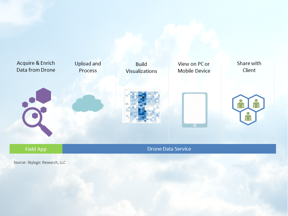
The good news is the current wave of development and innovation in online drone data services is focused on mapping and analytic solutions that drone business service providers can use to help customers solve real world problems – problems like infrastructure decay, crop yields, stockpile inaccuracies, improper construction sequencing, mining site logistics, etc. With so many choices, it can seem hard to know which one you should use. What advantage does one have over another? Unfortunately, the answers are not simple.  A lot depends on your business model, your target market, what functions you need, and quite frankly how much you are willing to spend.  With that in mind, I’ll outline below some simple criteria to help you evaluate the various web-based mapping and imaging services for drones.

Click on the image for a larger view.

Image courtesy of: Skylogic Research

THE PLAYERS: This lists most (but not all) major cloud-based drone data service providers that are (mostly) drone agnostic:

  • 4DMapper
  • AirGon
  • AgVault
  • Airware
  • DataMapper
  • Drone2Map for ArcGIS
  • DroneCloud
  • Drone Data Management System™
  • DroneDeploy
  • Dronifi
  • DroneMapper
  • FarmLense
  • Forge
  • Maps Made Easy
  • Propeller
  • Skycatch Commander
  • Trimble InSphere

THE TIPS:

    1. Know your business objectives — and ensure your provider does, too. Before signing up with a drone data mapping or imaging service provider, make sure that provider is fully committed to understanding the use case and the industry vertical you serve. Not all do. Some providers have more experience in one industry vs. another. For example, they may promote the functionality to serve mining when in fact their core functionality is based on serving agriculture.
    2. Know who’s behind the curtain – Choosing a data service provider means you are choosing a business partner.  Businesses come and go, and enterprises should ask hard questions about the portability of their data to avoid lock-in or potential loss if the business fails. So, if you are interested in the long term viability of that partner it’s always good to know who owns it, runs it, and funded it. For some vendors, this is easy.  For others it may take some digging. For example, DataMapper is owned by PrecisionHawk.  That was easy.  But did you know FarmSolutions is owned and run by the parent company of Dronifi?
    3. Pay attention to security, not just cost — Security and cost are also significant factors. Unfortunately, comparing vendors’ costs and security prowess isn’t always easy. In many cases, it’s simply not an apples-to-apples comparison. What’s more, tracking down information related to a provider’s costs and security strategy can be tough, but here’s what you want to know:
      • Access privileges: Service providers should be able to demonstrate they enforce adequate hiring, oversight, and access controls to enforce administrative delegation.
      • Regulatory compliance: You and your enterprises client are accountable for the data you collect — even when it’s in a cloud service. You should ensure the service provider you pick is ready and willing to undergo audits.
      • Data provenance – When selecting a provider, ask where their datacenters are located and if they can commit to specific privacy requirements – especially if you are serving agriculture. The farmer will want to know.
      • Data recovery – You must make sure your service provider has the ability to do a complete restoration in the event of a disaster. Your enterprise customer will ask.
    4. Check the box – When people ask me what’s the best drone service my answer is always “the one that best meets your particular requirements.”  If you don’t already have a list of requirements, then it’s time to get cracking.  Here’s a starter list. Note that some of these may not apply to the industry you want to serve:
      – Mosaic creation
      – Ortho-rectification
      – 3D point clouds
      – Digital elevation models – including digital surface models (DSM) and digital terrain models (DTM)
      – Crop health analysis tools (like NDVI)
      – Volume measurements
      – Plan overlays
      – Change detection
      – Manual or automatic shape identification
      – Feature extraction
      – Object recognition
      – Annotations
      – Automated reporting and task management tools
      – APIs and outputs for use in GIS, CAD and building information modeling (BIM) software.
      – Audit history
    5. Check their speeds and feeds – How fast do you want results? How do you want to see it? Do you need a preview? Do you want to access and enjoy full functionality on a mobile app, or is a using web browser all you need? These all matter – and may matter more to your client than to you.

BOTTOM LINE: At this time, the drone industry appears to be rich with online drone data services.  Keep in mind there are data services like Kespry and SiteScan which are cloud-based but packaged together with drones. You may want to consider them as well.  And then there are desktop and server-based data analytic software solutions like Pix4D and SimActive and Lockheed’s new Hydra Fusion Tools. These, too, may better fit your needs. Either way, you’ll want to do the same kind of evaluation because in the end they become your business partner.

20140718_ColinSnow_0024_1x1_WebColin Snow is CEO and Founder of Skylogic Research, LLC (aka Drone Analyst®), a research, content, and advisory services firm for the commercial drone industry. Colin is a 25-year technology industry veteran with a background in market research, enterprise software, electronics, digital imaging, and mobility.


Alan Phillips
Alan Phillips

Alan is serial entrepreneur, active angel investor, and a drone enthusiast. He co-founded DRONELIFE.com to address the emerging commercial market for drones and drone technology. Prior to DRONELIFE.com, Alan co-founded Where.com, ThinkingScreen Media, and Nurse.com. Recently, Alan has co-founded Crowditz.com,  a leader in Equity Crowdfunding Data, Analytics, and Insights.  Alan can be reached at alan(at)dronelife.com

Filed Under: Applications, Colin Snow, Commentary, News, Products, Top 5 Tagged With: big data, cloud, data services, drones

Reader Interactions

Comments

  1. Damon Burton says

    December 17, 2016 at 10:42 pm

    It is important that you should know your business objective. You must also ensure your provider does, too. Before signing up with a drone data mapping or imaging service provider, make sure that provider is fully committed to understanding the use case and the industry vertical you serve. This is really informative article. We learned so much.

    Reply

Trackbacks

  1. Big Data Challenges: Turn Your Stockpile Data Into Business Intelligence | Firmatek says:
    September 10, 2020 at 3:50 pm

    […] using a service provider for your stockpile measurements, make sure the provider is on board, too, Colin Snow writes at […]

    Reply
  2. 5 Tips for Evaluating Online Drone Data Services | Drone, UAV, Quadcopter a Multi Rotor News says:
    October 6, 2016 at 2:27 pm

    […] post 5 Tips for Evaluating Online Drone Data Services appeared first on […]

    Reply

Leave a Reply Cancel reply

Your email address will not be published. Required fields are marked *

Primary Sidebar

LATEST

FCC Updates Covered List, Introduces First Conditional Approvals for Drone Systems

Four systems receive time-limited approvals as a new case-by-case pathway takes shape News and Commentary.  The Federal Communications Commission (FCC)…

Continue Reading FCC Updates Covered List, Introduces First Conditional Approvals for Drone Systems

Volatus Aerospace Graduates to Toronto Stock Exchange

Volatus Aerospace Inc. will graduate to the Toronto Stock Exchange on March 20, 2026, trading under the symbol FLT. The…

Continue Reading Volatus Aerospace Graduates to Toronto Stock Exchange

Windracers ULTRA to Map Greenland’s Petermann Glacier

By Dronelife Features Editor Jim Magill An international team of researchers plans to deploy Windracers’ dual-use heavy-lift drone technology to…

Continue Reading Windracers ULTRA to Map Greenland’s Petermann Glacier

Africa Pavilion to Debut at XPONENTIAL Europe 2026

African Drone Forum initiative highlights growing role of African innovators in global autonomy ecosystem The African Drone Forum (ADF) has…

Continue Reading Africa Pavilion to Debut at XPONENTIAL Europe 2026

Everdrone Raises SEK 36 Million to Expand Drone-Based Emergency Healthcare Services

Funding supports commercialization and expansion of drone-delivered medical response systems across Europe Everdrone has raised SEK 36 million in a…

Continue Reading Everdrone Raises SEK 36 Million to Expand Drone-Based Emergency Healthcare Services

Palantir, Ondas, and World View Partner on Multi-Domain ISR Integration

Palantir Technologies, Ondas Inc., and World View Enterprises have announced a strategic partnership to develop an AI-enabled operational architecture for multi-domain…

Continue Reading Palantir, Ondas, and World View Partner on Multi-Domain ISR Integration

Alpine Eagle Scales Counter-Drone Production as European Demand Grows

Sentinel system expansion reflects rising need for deployable, cost-effective air defense solutions Alpine Eagle, a European counter-drone technology company, is…

Continue Reading Alpine Eagle Scales Counter-Drone Production as European Demand Grows

Fortem DroneHunter and TrueView Radar Join Lockheed Martin Sanctum

Fortem Technologies has announced a new contract with Lockheed Martin to deploy autonomous counter-drone systems for critical infrastructure protection. The…

Continue Reading Fortem DroneHunter and TrueView Radar Join Lockheed Martin Sanctum

DHS Taps Fortem for Kinetic Counter-UAS Systems at World Cup Venues

By Dronelife Features Editor Jim Magill (Editor’s note: This story is part of a series of reports on efforts to…

Continue Reading DHS Taps Fortem for Kinetic Counter-UAS Systems at World Cup Venues

DroneShield Integrates Robin Radar for Layered Drone Airspace Protection

DroneShield has announced a new partnership with Robin Radar Systems to expand its counter-UAS sensor ecosystem. The agreement integrates Robin’s…

Continue Reading DroneShield Integrates Robin Radar for Layered Drone Airspace Protection

Secondary Sidebar

Footer

SPONSORED

Inspired Flight Gremsy IF800 VIO F1 drones geo week

What Will It Take to Strengthen U.S. Drone Manufacturing? A Conversation with Inspired Flight’s CEO

Global Mapper Mobile data collection

Collection Ground Control Points with Global Mapper Mobile

Military Drone Mapping Solutions

How SimActive’s Correlator3D™ is Revolutionizing Military Mapping: An Exclusive Interview with CEO Philippe Simard

Photogrammetry Accuracy Standards

SimActive Photogrammetry Software: Enabling Users to Meet Accuracy Standards for Over 20 Years

NACT Engineering Parrot ANAFI tether indoor shot

Smart Tether for Parrot ANAFI USA from NACT Engineering

Blue Marble, features global mapper, features Blue Marble

Check Out These New Features in Global Mapper v25 from Blue Marble

About Us | Contact Us | Advertise With Us | Write for Us | Privacy Policy | Terms of Service

The Trusted Source for the Business of Drones.

This website uses cookies and third party services. By clicking OK, you are agreeing to our privacy policy. ACCEPT

Manage consent

Privacy Overview

This website uses cookies to improve your experience while you navigate through the website. Out of these, the cookies that are categorized as necessary are stored on your browser as they are essential for the working of basic functionalities of the website. We also use third-party cookies that help us analyze and understand how you use this website. These cookies will be stored in your browser only with your consent. You also have the option to opt-out of these cookies. But opting out of some of these cookies may affect your browsing experience.
Necessary
Always Enabled
Necessary cookies are absolutely essential for the website to function properly. These cookies ensure basic functionalities and security features of the website, anonymously.
CookieDurationDescription
cookielawinfo-checkbox-analytics11 monthsThis cookie is set by GDPR Cookie Consent plugin. The cookie is used to store the user consent for the cookies in the category "Analytics".
cookielawinfo-checkbox-functional11 monthsThe cookie is set by GDPR cookie consent to record the user consent for the cookies in the category "Functional".
cookielawinfo-checkbox-necessary11 monthsThis cookie is set by GDPR Cookie Consent plugin. The cookies is used to store the user consent for the cookies in the category "Necessary".
cookielawinfo-checkbox-others11 monthsThis cookie is set by GDPR Cookie Consent plugin. The cookie is used to store the user consent for the cookies in the category "Other.
cookielawinfo-checkbox-performance11 monthsThis cookie is set by GDPR Cookie Consent plugin. The cookie is used to store the user consent for the cookies in the category "Performance".
viewed_cookie_policy11 monthsThe cookie is set by the GDPR Cookie Consent plugin and is used to store whether or not user has consented to the use of cookies. It does not store any personal data.
Functional
Functional cookies help to perform certain functionalities like sharing the content of the website on social media platforms, collect feedbacks, and other third-party features.
Performance
Performance cookies are used to understand and analyze the key performance indexes of the website which helps in delivering a better user experience for the visitors.
Analytics
Analytical cookies are used to understand how visitors interact with the website. These cookies help provide information on metrics the number of visitors, bounce rate, traffic source, etc.
Advertisement
Advertisement cookies are used to provide visitors with relevant ads and marketing campaigns. These cookies track visitors across websites and collect information to provide customized ads.
Others
Other uncategorized cookies are those that are being analyzed and have not been classified into a category as yet.
SAVE & ACCEPT