• Skip to main content
  • Skip to secondary menu
  • Skip to primary sidebar
  • Skip to secondary sidebar
  • Skip to footer
  • DroneRacingLife
  • DroneFlyers
  • Newsletter
DroneLife

DRONELIFE

Stay up to date on all the latest Drone News

  • News
  • Products
  • Industries
    • Agriculture
    • Construction
    • Delivery
    • Dual Use
    • Inspection
    • Public Safety
    • Surveying
  • Enthusiasts
  • Regulations
  • Business
  • Video
  • Podcasts

3 Incredible Ways Drones are Saving the Environment

July 21, 2016 by Miriam McNabb 4 Comments

saving the environment
Credit: NOAA Fisheries, Vancouver Aquarium. Taken by UAV from above 90 feet under Fisheries and Oceans Canada research permit and Transport Canada flight authorization.

The National Oceanic and Atmospheric Administration (NOAA) is at the forefront of the fight to save the planet – and they’ll use any tool available to do so.  Here are three incredible ways that NOAA’s drones are saving the environment.

NOAA’s unmanned systems program is a research project, explains Robbie Hood, Director of the Unmanned Aircraft Systems Program at NOAA.  “It’s an exploratory program to evaluate how useful the drones will be,” Ms. Hood says. “Our real job is to help people understand both what’s happening today and what’s going to happen tomorrow… and that takes a lot of data.  Unmanned technology can help us get data that we can’t get any other way.”

NOAA uses drones in several different ways; sometimes because drones are simply more efficient, and other times because they are the safest option – either for people or for wildlife.  Drones are used in research about high impact weather, marine observations, and polar regions.  In every situation that NOAA is researching, Ms. Hood explains, information is key. “Can we collect data that can help us understand what is changing?”

High impact weather events – events like tornadoes, hurricanes, or tropical storms that will have a significant effect on people’s safety and the economy – are by definition dangerous to track.  That’s when a drone can be utilized, gathering data in areas that could be hazardous for researchers.

In the polar regions, where extreme conditions and seas make research difficult, “There are several applications,” says Hood.  “In the polar regions, there is a lot happening with ice change – being able to get a more detailed map of the ice is critical.”  This summer, a Saildrone, attached to the NOAA Ship Oscar Dyson, will study ocean conditions in the Bering Sea.  The Saildrone will gather data from the Arctic and beam it back to researchers at NOAA’s Pacific Marine Environmental Laboratory; the drone will capture data about the ocean environment and wildlife such as whales and seals. “Using UAS from a ship can significantly increase the observing radius of the ship,” Hood points out.

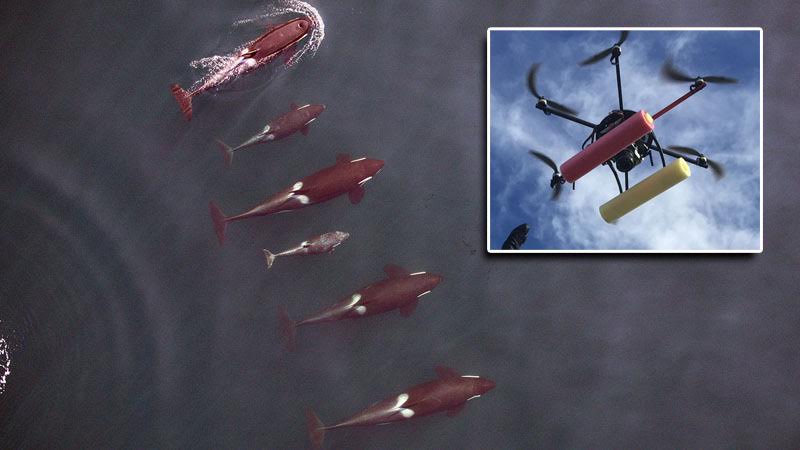
In other cases, using a drone  is the best solution for the environment.  Earlier this year, NOAA used small hexacopter drones to track the health of endangered killer whales.  Using the precise drone photogrammetry – which is the science of taking measurements from images – they were able to accurately establish pod health, all without disturbing the whales.  “We can’t put a live whale on a scale to assess its weight and overall health,” NOAA researcher John Durban said in a NOAA article. “But now we can give it a remote checkup without it even knowing we are there.”

Sometimes the environment itself is better off for not being stepped on.  And NOAA is using drones to monitor those delicate ecosystems, like marsh wetlands in Mississippi. Researchers used drones launched from ships in 2015 in order to gather data about the extent of damage right after a lightning strike caused a huge marsh fire along the Mississippi coast.

NOAA says that drones are proving to be cost-effective, fast, and safe – all good news for both researchers and the growing drone industry, anxious to demonstrate that drones can be good for everyone – including the planet.

Miriam McNabb

Miriam McNabb is the Editor-in-Chief of DRONELIFE and CEO of JobForDrones, a professional drone services marketplace, and a fascinated observer of the emerging drone industry and the regulatory environment for drones. Miriam has penned over 3,000 articles focused on the commercial drone space and is an international speaker and recognized figure in the industry.  Miriam has a degree from the University of Chicago and over 20 years of experience in high tech sales and marketing for new technologies.
For drone industry consulting or writing, Email Miriam.

TWITTER:@spaldingbarker

Subscribe to DroneLife here.

Filed Under: DL Exclusive, News Tagged With: Drones For Good, environmental drones, NOAA, ocean drones, Saildrone

Reader Interactions

Comments

  1. Rachel says

    August 15, 2016 at 10:29 am

    I’m glad to see that drones are becoming more practical and helpful as the technology develops. Thank you for sharing.

    Reply

Trackbacks

  1. 5 Ways that UAVs Help in Hurricanes | Icon Aerial Media says:
    October 14, 2016 at 12:49 pm

    […] predict extreme weather more accurately – and better understand what’s happening. Drones are heavily used by NOAA to monitor weather patterns, and new research shows that drones have unique capabilities in […]

    Reply
  2. 5 Ways that Drones Help in Hurricanes - DFW FlyBy PhotograpghyDFW FlyBy Photograpghy | Drone Services & Aerial Cinematography – FAA Approved says:
    October 13, 2016 at 4:26 pm

    […] predict extreme weather more accurately – and better understand what’s happening. Drones are heavily used by NOAA to monitor weather patterns, and new research shows that drones have unique capabilities in […]

    Reply
  3. Floating Drones: Saildrone Gets $14 million in Funding - DFW FlyBy PhotograpghyDFW FlyBy Photograpghy | Drone Services & Aerial Cinematography – FAA Approved says:
    September 14, 2016 at 12:41 pm

    […] “a provider of ocean data collected by a fleet of unmanned, autonomous sailing drones.”  Used by NOAA as part of their drone exploration program, the company says that Saildrones have now covered over […]

    Reply

Leave a Reply Cancel reply

Your email address will not be published. Required fields are marked *

Primary Sidebar

LATEST

5 Federal Drone Policies Flying Under the Radar This Summer

From World Cup airspace restrictions to critical infrastructure rulemaking, several federal initiatives could shape the drone industry in the months…

Continue Reading 5 Federal Drone Policies Flying Under the Radar This Summer

Drone Industry Insights Launches the 9th Edition of the Global Drone Survey — The World’s Largest Annual Industry Survey for the Drone Market

Survey open to all actors in the global drone market ecosystem — manufacturers, operators, investors, associations, regulators, and service providers…

Continue Reading Drone Industry Insights Launches the 9th Edition of the Global Drone Survey — The World’s Largest Annual Industry Survey for the Drone Market

Proposed Patent Bill Could Have Major Implications for Drone Industry Intellectual Property

Prohibiting Adversarial Patents Act would make certain patents unenforceable while leaving ownership intact A newly introduced bill in Congress concerning…

Continue Reading Proposed Patent Bill Could Have Major Implications for Drone Industry Intellectual Property

Seattle Stadium “No-Drone Zone” During FIFA Matches

By Dronelife Features Editor Jim Magill Federal officials on Monday urged drone operators to stay away from Lumen Field, which…

Continue Reading Seattle Stadium “No-Drone Zone” During FIFA Matches

Landair Surveys Uses SimActive Correlator3D for Planned Burns Mapping in Australia

The Australian geospatial firm is using Correlator3D to generate orthomosaics from aerial imagery captured for wildfire prevention and land management…

Continue Reading Landair Surveys Uses SimActive Correlator3D for Planned Burns Mapping in Australia

As Disaster Risks Grow, WingXpand and Verizon Explore New Tools for Emergency Response

WingXpand will work with Verizon Frontline and emergency teams to explore new tools for disaster assessment and community resilience As…

Continue Reading As Disaster Risks Grow, WingXpand and Verizon Explore New Tools for Emergency Response

HOVERAir’s UK Launch Raises a Bigger Question: Who Will Serve America’s Consumer Drone Market?

HOVERAir has announced the UK launch of its new X1 Smart, a 99-gram self-flying camera designed to make aerial content…

Continue Reading HOVERAir’s UK Launch Raises a Bigger Question: Who Will Serve America’s Consumer Drone Market?

DRONELIFE Exclusive Interview: Inside PDW’s Strategy to Build Drones That Can Operate When GPS and Communications Fail

PDW works to develop advanced drone communications systems By DRONELIFE Features Editor Jim Magill As modern warfare increasingly relies on…

Continue Reading DRONELIFE Exclusive Interview: Inside PDW’s Strategy to Build Drones That Can Operate When GPS and Communications Fail

AirData UAV and LeoSight Bring Live Drone Data for DFR Programs

The new LeoSight AirData integration streams real-time flight data, telemetry, and operational insights from AirData directly into LeoCommand, giving dispatchers…

Continue Reading AirData UAV and LeoSight Bring Live Drone Data for DFR Programs

New Boson SX8 Brings High-Resolution Thermal Imaging to NDAA-Compliant Drone Payloads

New thermal imaging module combines SXGA resolution with compact size and U.S. manufacturing Teledyne FLIR OEM has announced the Boson…

Continue Reading New Boson SX8 Brings High-Resolution Thermal Imaging to NDAA-Compliant Drone Payloads

Secondary Sidebar

Footer

SPONSORED

Inspired Flight Gremsy IF800 VIO F1 drones geo week

What Will It Take to Strengthen U.S. Drone Manufacturing? A Conversation with Inspired Flight’s CEO

Global Mapper Mobile data collection

Collection Ground Control Points with Global Mapper Mobile

Military Drone Mapping Solutions

How SimActive’s Correlator3D™ is Revolutionizing Military Mapping: An Exclusive Interview with CEO Philippe Simard

Photogrammetry Accuracy Standards

SimActive Photogrammetry Software: Enabling Users to Meet Accuracy Standards for Over 20 Years

NACT Engineering Parrot ANAFI tether indoor shot

Smart Tether for Parrot ANAFI USA from NACT Engineering

Blue Marble, features global mapper, features Blue Marble

Check Out These New Features in Global Mapper v25 from Blue Marble

About Us | Contact Us | Advertise With Us | Write for Us | Privacy Policy | Terms of Service

The Trusted Source for the Business of Drones.

This website uses cookies and third party services. By clicking OK, you are agreeing to our privacy policy. ACCEPT

Manage consent

Privacy Overview

This website uses cookies to improve your experience while you navigate through the website. Out of these, the cookies that are categorized as necessary are stored on your browser as they are essential for the working of basic functionalities of the website. We also use third-party cookies that help us analyze and understand how you use this website. These cookies will be stored in your browser only with your consent. You also have the option to opt-out of these cookies. But opting out of some of these cookies may affect your browsing experience.
Necessary
Always Enabled
Necessary cookies are absolutely essential for the website to function properly. These cookies ensure basic functionalities and security features of the website, anonymously.
CookieDurationDescription
cookielawinfo-checkbox-analytics11 monthsThis cookie is set by GDPR Cookie Consent plugin. The cookie is used to store the user consent for the cookies in the category "Analytics".
cookielawinfo-checkbox-functional11 monthsThe cookie is set by GDPR cookie consent to record the user consent for the cookies in the category "Functional".
cookielawinfo-checkbox-necessary11 monthsThis cookie is set by GDPR Cookie Consent plugin. The cookies is used to store the user consent for the cookies in the category "Necessary".
cookielawinfo-checkbox-others11 monthsThis cookie is set by GDPR Cookie Consent plugin. The cookie is used to store the user consent for the cookies in the category "Other.
cookielawinfo-checkbox-performance11 monthsThis cookie is set by GDPR Cookie Consent plugin. The cookie is used to store the user consent for the cookies in the category "Performance".
viewed_cookie_policy11 monthsThe cookie is set by the GDPR Cookie Consent plugin and is used to store whether or not user has consented to the use of cookies. It does not store any personal data.
Functional
Functional cookies help to perform certain functionalities like sharing the content of the website on social media platforms, collect feedbacks, and other third-party features.
Performance
Performance cookies are used to understand and analyze the key performance indexes of the website which helps in delivering a better user experience for the visitors.
Analytics
Analytical cookies are used to understand how visitors interact with the website. These cookies help provide information on metrics the number of visitors, bounce rate, traffic source, etc.
Advertisement
Advertisement cookies are used to provide visitors with relevant ads and marketing campaigns. These cookies track visitors across websites and collect information to provide customized ads.
Others
Other uncategorized cookies are those that are being analyzed and have not been classified into a category as yet.
SAVE & ACCEPT