• Skip to main content
  • Skip to secondary menu
  • Skip to primary sidebar
  • Skip to secondary sidebar
  • Skip to footer
  • DroneRacingLife
  • DroneFlyers
  • Newsletter
DroneLife

DRONELIFE

Stay up to date on all the latest Drone News

  • News
  • Products
  • Industries
    • Agriculture
    • Construction
    • Delivery
    • Dual Use
    • Inspection
    • Public Safety
    • Surveying
  • Enthusiasts
  • Regulations
  • Business
  • Video
  • Podcasts

Virginia Tech COA Enables Long-distance Flight Surveying of Energy Corridors, Infrastructure

May 29, 2016 by Alan Phillips 1 Comment

An RS-20 unmanned aircraft flies over an energy pipeline route near Farmville, Virginia. Photo courtesy of American Aerospace Technologies Inc.

The Federal Aviation Administration has approved a new flight corridor in central Virginia for unnamed aircraft testing.

The Virginia Tech Mid-Atlantic Aviation Partnership has received a Certificate of Authorization from the Federal Aviation Administration for research flights up to 7,000 feet in altitude in an area of nearly 5,000 square miles in central Virginia.

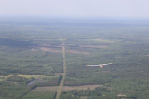
The first flight under the new Certificate of Authorization was conducted successfully on May 11, according to a Virginia Tech media release.

The newly authorized airspace covers more than 10 percent of the land area in the state and includes a unique set of critical infrastructure such as airports, power plants, electric lines, energy pipelines, and rail lines, officials said.

Researchers said the new Federal Aviation Administration-approved flight corridor will accelerate testing and development of further safe commercial integration of unmanned aircraft systems.

Researchers are expected to explore the safety and feasibility of flights beyond the visual line of sight, Virginia Tech Mid-Atlantic Aviation Partnership representatives said.

The Certificate of Authorization includes land in Buckingham, Nottoway, Cumberland, Fluvanna, Prince Edward, Charlotte, Appomattox, Louisa, Goochland, Powhatan, Amelia, Lunenburg, Halifax, Pittsylvania, and Campbell counties.

“Getting that large an area in the mid-Atlantic region is significant,” said Rose Mooney, the executive director of the Virginia Tech Mid-Atlantic Aviation Partnership, which is headquartered at the Institute for Critical Technology and Applied Science. “We’re in the heart of aviation country: we have a lot of flights, a lot of infrastructure, and a lot going on. If we can do these types of flights safely here, we can do them virtually anywhere.”

Virginia Tech is a leader in unmanned aircraft systems research, which has led to pioneering work across disciplines, from agriculture to journalism to emergency management.

The university also oversees one of only six national test sites for unmanned aircraft systems in the country. Some of the university’s groundbreaking missions include the first research flights investigating medical supply delivery to remote locations and work with NASA towards a traffic management system for unmanned aircraft.


Alan Phillips
Alan Phillips

Alan is serial entrepreneur, active angel investor, and a drone enthusiast. He co-founded DRONELIFE.com to address the emerging commercial market for drones and drone technology. Prior to DRONELIFE.com, Alan co-founded Where.com, ThinkingScreen Media, and Nurse.com. Recently, Alan has co-founded Crowditz.com,  a leader in Equity Crowdfunding Data, Analytics, and Insights.  Alan can be reached at alan(at)dronelife.com

Filed Under: Applications, Featured - Surveying, Industries, Inspection, News Tagged With: Institute for Critical Technology and Applied Science, Survey, Virginia Tech, Virginia Tech Mid-Atlantic Aviation Partnership

Reader Interactions

Trackbacks

  1. Virginia Tech COA Enables Long-distance Flight Surveying of Energy Corridors, Infrastructure | Drone, UAV, Quadcopter a Multi Rotor News says:
    May 29, 2016 at 12:17 pm

    […] post Virginia Tech COA Enables Long-distance Flight Surveying of Energy Corridors, Infrastructure appeared first on […]

    Reply

Leave a Reply Cancel reply

Your email address will not be published. Required fields are marked *

Primary Sidebar

LATEST

Buffalo’s Natrion Rolls Out NDAA-Compliant Drone Battery Cells

The Buffalo-based battery materials company debuts NDAA-compliant pouch cells with up to 80% more energy density than standard Li-ion. Natrion…

Continue Reading Buffalo’s Natrion Rolls Out NDAA-Compliant Drone Battery Cells

ePropelled Launches Integrated Power System for Agricultural Drones

New propulsion platform targets growing precision agriculture UAV market As agricultural drone adoption continues to expand worldwide, ePropelled has introduced…

Continue Reading ePropelled Launches Integrated Power System for Agricultural Drones

FAA and DoD Are Building the Rules for Drones Operating Near Sensitive Airspace

FAA and DoD Explore How Drones, Counter-UAS Systems, and Airports Can Share Airspace XPONENTIAL panel highlights growing cooperation between civil…

Continue Reading FAA and DoD Are Building the Rules for Drones Operating Near Sensitive Airspace

Urban UAV Operations Need More than Drones

Cloud Century has implemented more than 200 drone docks in China, learning what urban drone operations require. In this guest…

Continue Reading Urban UAV Operations Need More than Drones

MatrixSpace Brings Portable Counter-Drone Radar to Lithuanian Exercise

The xTechCounter Strike winner deploys portable AI-powered radar to strengthen low-altitude airspace awareness for M-SHORAD units in Pabradė. MatrixSpace is…

Continue Reading MatrixSpace Brings Portable Counter-Drone Radar to Lithuanian Exercise

Industrial Policy and Wright’s Law: A New Perspective on Building the U.S. Drone Industry

At the AUVSI XPONENTIAL 2026 conference this week, Red Cat Holdings executive Brendan Stewart delivered one of the more historically…

Continue Reading Industrial Policy and Wright’s Law: A New Perspective on Building the U.S. Drone Industry

How DHS Is Helping World Cup Host Cities Get Counter-UAS Ready Before FIFA 2026

DHS lab equips World Cup cities with counter-drone guidance. By DRONELIFE Features Editor Jim Magill (Editor’s note: This is part…

Continue Reading How DHS Is Helping World Cup Host Cities Get Counter-UAS Ready Before FIFA 2026

Project ULTRA Aims to Normalize Drone Operations in Shared Airspace

FAA, DoD, and industry partners use Grand Forks test environment to develop scalable systems for UAS, logistics, and counter-UAS coordination…

Continue Reading Project ULTRA Aims to Normalize Drone Operations in Shared Airspace

Michigan’s Bet on the Low Altitude Economy: How M Air Connects Aerospace Innovation and Detroit Manufacturing

At XPONENTIAL 2026 this week, leaders from University of Michigan outlined an ambitious vision for the future of drones and…

Continue Reading Michigan’s Bet on the Low Altitude Economy: How M Air Connects Aerospace Innovation and Detroit Manufacturing

CVS, SkyfireAI, and Thales Outline Drone-Based Healthcare Response Network at XPONENTIAL 2026

Panel highlights healthcare logistics, emergency response, and disaster resilience as key drone use cases At the XPONENTIAL 2026 conference in…

Continue Reading CVS, SkyfireAI, and Thales Outline Drone-Based Healthcare Response Network at XPONENTIAL 2026

Secondary Sidebar

Footer

SPONSORED

Inspired Flight Gremsy IF800 VIO F1 drones geo week

What Will It Take to Strengthen U.S. Drone Manufacturing? A Conversation with Inspired Flight’s CEO

Global Mapper Mobile data collection

Collection Ground Control Points with Global Mapper Mobile

Military Drone Mapping Solutions

How SimActive’s Correlator3D™ is Revolutionizing Military Mapping: An Exclusive Interview with CEO Philippe Simard

Photogrammetry Accuracy Standards

SimActive Photogrammetry Software: Enabling Users to Meet Accuracy Standards for Over 20 Years

NACT Engineering Parrot ANAFI tether indoor shot

Smart Tether for Parrot ANAFI USA from NACT Engineering

Blue Marble, features global mapper, features Blue Marble

Check Out These New Features in Global Mapper v25 from Blue Marble

About Us | Contact Us | Advertise With Us | Write for Us | Privacy Policy | Terms of Service

The Trusted Source for the Business of Drones.

This website uses cookies and third party services. By clicking OK, you are agreeing to our privacy policy. ACCEPT

Manage consent

Privacy Overview

This website uses cookies to improve your experience while you navigate through the website. Out of these, the cookies that are categorized as necessary are stored on your browser as they are essential for the working of basic functionalities of the website. We also use third-party cookies that help us analyze and understand how you use this website. These cookies will be stored in your browser only with your consent. You also have the option to opt-out of these cookies. But opting out of some of these cookies may affect your browsing experience.
Necessary
Always Enabled
Necessary cookies are absolutely essential for the website to function properly. These cookies ensure basic functionalities and security features of the website, anonymously.
CookieDurationDescription
cookielawinfo-checkbox-analytics11 monthsThis cookie is set by GDPR Cookie Consent plugin. The cookie is used to store the user consent for the cookies in the category "Analytics".
cookielawinfo-checkbox-functional11 monthsThe cookie is set by GDPR cookie consent to record the user consent for the cookies in the category "Functional".
cookielawinfo-checkbox-necessary11 monthsThis cookie is set by GDPR Cookie Consent plugin. The cookies is used to store the user consent for the cookies in the category "Necessary".
cookielawinfo-checkbox-others11 monthsThis cookie is set by GDPR Cookie Consent plugin. The cookie is used to store the user consent for the cookies in the category "Other.
cookielawinfo-checkbox-performance11 monthsThis cookie is set by GDPR Cookie Consent plugin. The cookie is used to store the user consent for the cookies in the category "Performance".
viewed_cookie_policy11 monthsThe cookie is set by the GDPR Cookie Consent plugin and is used to store whether or not user has consented to the use of cookies. It does not store any personal data.
Functional
Functional cookies help to perform certain functionalities like sharing the content of the website on social media platforms, collect feedbacks, and other third-party features.
Performance
Performance cookies are used to understand and analyze the key performance indexes of the website which helps in delivering a better user experience for the visitors.
Analytics
Analytical cookies are used to understand how visitors interact with the website. These cookies help provide information on metrics the number of visitors, bounce rate, traffic source, etc.
Advertisement
Advertisement cookies are used to provide visitors with relevant ads and marketing campaigns. These cookies track visitors across websites and collect information to provide customized ads.
Others
Other uncategorized cookies are those that are being analyzed and have not been classified into a category as yet.
SAVE & ACCEPT