- RigiTech Targets Logistics Firms With Scalable Drone Delivery
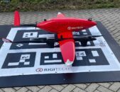
 Rigi Technologies SA, a Swiss developer of long-range drone logistics solutions, announced a strategic expansion on November 26 aimed at enabling logistics companies to deploy and scale drone delivery operations in Europe and the United States. Building on its established record of commercial flights and regulatory certifications, RigiTech’s approach centers on providing logistics operators with… Read more: RigiTech Targets Logistics Firms With Scalable Drone Delivery
 - How AI Is Pushing Industrial Drone Use Into a New Era
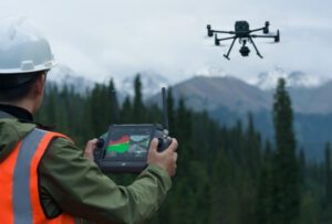
 AI tools set to trigger rapid industry adoption of drones By DRONELIFE Features Editor Jim Magill Although over the past couple of decades some heavy industries have been quick to adopt the use of drones and robotics to perform tasks that are difficult to dangerous for humans to perform, the introduction of the next generation… Read more: How AI Is Pushing Industrial Drone Use Into a New Era
 - DroneDeploy Introduces Agentic AI and Robotics Advancements at Horizons 2025
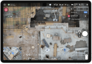
 New AI capabilities and platform upgrades aim to improve accuracy, automation and safety DroneDeploy announced major product innovations at the Horizons 2025 conference in San Francisco. The company says the new solutions will improve how field teams capture and analyze data in construction, energy, utilities and industrial environments. Mike Winn, CEO and co founder of… Read more: DroneDeploy Introduces Agentic AI and Robotics Advancements at Horizons 2025
 - Companies Complete First Fully Automated Counter-Drone Interception in Baltic Region
 DefSecIntel Solutions and Origin Robotics completed what they describe as the first fully automated counter-unmanned aircraft system (C-UAS) interception demonstration in the Baltic region during a live trial conducted in Latvia. The demonstration integrated DefSecIntel’s EIRSHIELD ultra-short-range C-UAS system with Origin Robotics’ autonomous BLAZE interceptor to engage representative hostile UAV profiles. The trial validated an… Read more: Companies Complete First Fully Automated Counter-Drone Interception in Baltic Region
 - Managing Large Photogrammetry Projects Simultaneously: Can It Be Done?

 How scalable workflows, automation, and distributed processing make managing large photogrammetry projects possible. DRONELIFE spoke with Philippe Simard, co-founder and CEO of SimActive, the Canadian company behind the Correlator3D photogrammetry suite, to explore one of the most pressing challenges in the aerial mapping industry: how to efficiently manage and process massive datasets from large-scale projects,… Read more: Managing Large Photogrammetry Projects Simultaneously: Can It Be Done?
 - From the Floor Of Intergeo 2025: GeoCue Announces NDAA-Compliant TrueView 641 Aerial LiDAR Sensor
 GeoCue unveiled the TrueView 641 at INTERGEO 2025, a new NDAA-compliant aerial LiDAR sensor designed to meet growing demand from surveying and engineering companies across the United States and worldwide. The engineering-grade sensor addresses the increasing number of Federal, State, Local, and Educational contracts requiring NDAA compliance while maintaining cost accessibility without compromising performance. The… Read more: From the Floor Of Intergeo 2025: GeoCue Announces NDAA-Compliant TrueView 641 Aerial LiDAR Sensor
 - From the Floor of Intergeo 2025: Xer Showcases Their Hybrid-Electric X8 Infrastructure Inspection Drone

 Swiss manufacturer Xer Technologies presented its Xer X8 hybrid-electric unmanned aircraft system at Intergeo 2025 in Frankfurt, demonstrating the platform’s advanced capabilities for large-scale infrastructure monitoring operations. The Xer X8 addresses critical operational limitations of battery-powered drones through innovative hybrid propulsion technology. Xer X8 Technical Specifications and Performance The Xer X8, (available in an NDAA-compliant… Read more: From the Floor of Intergeo 2025: Xer Showcases Their Hybrid-Electric X8 Infrastructure Inspection Drone
 - From the Floor of InterGeo 2025: Axpo’s LINIA Software Suite Offers Complete Drone Powerline Inspection Solutions
 As grid operators worldwide harness drone technology for the crucial, time-and-labor-intensive process of powerline inspection, Swiss power company Axpo has acquired comprehensive in-house systems and now offers these solutions across Europe and worldwide. Axpo showcased their suite of software services at Intergeo 2025, demonstrating tools designed to streamline powerline inspection using various drone platforms. Their… Read more: From the Floor of InterGeo 2025: Axpo’s LINIA Software Suite Offers Complete Drone Powerline Inspection Solutions
 - 10 Initial Takeaways from the FAA’s BVLOS Drone NPRM: What Operators Need to Know
 The Federal Aviation Administration (FAA) has published its long-awaited Notice of Proposed Rulemaking (NPRM) for Beyond Visual Line of Sight (BVLOS) drone operations, signaling a pivotal shift for the U.S. commercial drone industry. Announced today, August 5, 2025 by U.S. Transportation Secretary Sean P. Duffy, this proposed framework is expected to enable routine BVLOS activities—from… Read more: 10 Initial Takeaways from the FAA’s BVLOS Drone NPRM: What Operators Need to Know
 - DroneDeploy Launches Progress AI to Automate Construction Tracking
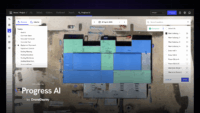
 New AI tool delivers accurate jobsite updates in minutes, saving time and reducing risk DroneDeploy Introduces AI-Powered Construction Progress Tool DroneDeploy has announced the launch of Progress AI, an artificial intelligence tool that automates construction progress tracking from drone and 360-degree camera data. Designed to replace time-consuming manual updates, Progress AI generates fast and reliable… Read more: DroneDeploy Launches Progress AI to Automate Construction Tracking
 - Eagleview Introduces Unified Platform and New Brand Identity for Asset Intelligence

 Company Launches Eagleview One, Expands AI and 3D Analytics in Changing Drone Industry Eagleview has announced the launch of Eagleview One™, a unified platform designed to deliver asset intelligence through aerial and drone imagery, AI-powered analytics, and high-precision 3D models. This launch marks the completion of a multi-year transformation and introduces a new brand identity… Read more: Eagleview Introduces Unified Platform and New Brand Identity for Asset Intelligence
 - SimActive Software Enhances Construction Mapping for Bullseye Construction

 SimActive’s Correlator3D™ software is being used for real-time mapping on construction projects. SimActive Inc. has announced that its photogrammetry software, Correlator3D™, is being used by Bullseye Construction to map large-scale construction projects. This collaboration allows Bullseye Construction to generate highly accurate map products such as digital surface models (DSMs), point clouds, and orthomosaics. By leveraging… Read more: SimActive Software Enhances Construction Mapping for Bullseye Construction
 - Skydio, Trimble Partner to Bring Centimeter Level Accuracy to the X10
 Skydio and Trimble Collaborate on New Integration for Utilities, Construction and State Transportation Agencies by DRONELIFE Staff Writer Ian J. McNabb Skydio, a California-based drone and UAV manufacturer focused on autonomy, recently announced a new strategic partnership with Trimble to create new integrated workflows designed to unite data capture, data visualization, and data analytics for… Read more: Skydio, Trimble Partner to Bring Centimeter Level Accuracy to the X10
 - US-Based Drone Services Provider FlyGuys Scores $10 Million in Series A to Expand
 Louisiana based drone services provider FlyGuys has scored a $10 million Series A funding round to scale their SaaS solutions platform and expand their nationwide presence. It’s a positive indicator for the US drone industry. Founded in 2014, early player FlyGuys has a nationwide presence, serving enterprise clients in a wide range of industries including agriculture,… Read more: US-Based Drone Services Provider FlyGuys Scores $10 Million in Series A to Expand
 - Automating Reality Capture on Job Sites with Drones, Ground Robots, and More: Users Perspective

 On the second day of the DroneDeploy conference in Denver, an enterprise panel discussed what automation means on the jobsite – capturing data with automated drones, ground robots, and more. Continue reading below, or listen: DroneLife · Automated – Drones – Ground – Robots – For – Reality – CaptureThis year’s DroneDeploy conference has been… Read more: Automating Reality Capture on Job Sites with Drones, Ground Robots, and More: Users Perspective
 - NC DOT to Deploy Remote Drone Operations at Construction Sites: the Path to Routine, BVLOS Inspections
 NC DOT Wins FAA Waiver for Remote, BVLOS Ops at Construction Sites Continue reading below, or listen: DroneLife · NC – DOT – Receives – FAA – BVLOS – Waiver – For – Remote – Inspections NC has been a leader in advancing drone operations. Now, the NC DOT announces an FAA waiver to remotely… Read more: NC DOT to Deploy Remote Drone Operations at Construction Sites: the Path to Routine, BVLOS Inspections
 - Indoor Inspections, Concrete Repair Spray, and More: Japan Drone and International Advanced Air Mobility EXPO
 This article published in collaboration with JUIDA, the Japan UAS Industrial Development Association. Japan Drone/International Advanced Air Mobility EXPO 2023 by DRONELIFE Staff Writer Ian J. McNabb The “Japan Drone/International Advanced Air Mobility EXPO 2023”, sponsored by JUIDA at the Makuhari Messe convention center in Chiba City, ended on June 26th after three days of… Read more: Indoor Inspections, Concrete Repair Spray, and More: Japan Drone and International Advanced Air Mobility EXPO
 - DroneDeploy Conference: The Future is Here
 At this week’s DroneDeploy conference, DroneDeploy co-founder Mike Winn says that despite the challenges of 2020, the future of drone mapping, and the drone community, is here. In an opening address, Winn presented a fascinating view of the worksite of the future, using the construction industry as an example. “Almost every industry involves construction of… Read more: DroneDeploy Conference: The Future is Here
 - Pix4D announces Stand-Alone Photogrammetry with Cloud Processing
 Pix4D launches stand-alone photogrammetry cloud processing solutions Lausanne, Switzerland, June 9th, 2020: Pix4D, the photogrammetry and drone-mapping industry leader, announces today the release of Pix4Dcloud and Pix4Dcloud Advanced: the new mapping platforms for online surveying workflows and construction site monitoring. These stand-alone cloud products run Pix4D’s photogrammetry algorithms for mapping and modeling reality from images. Pix4Dcloud Advanced extends the functionalities… Read more: Pix4D announces Stand-Alone Photogrammetry with Cloud Processing
 - DJI Mavic Air 2 Announcement: Today is the Day
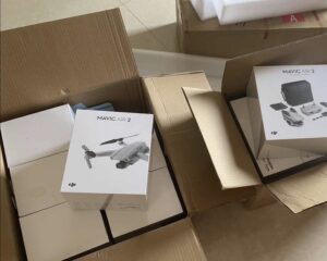
 DJI Mavic Air 2 Announcement is scheduled for today. The long anticipated and often rumored DJI Mavic Air 2 announcement will occur tonight – we think. DJI is going to announce something later today, April 27 at 9:30 pm EDT, or the webmaster is going to have some explaining to do. The Brazilian certification body… Read more: DJI Mavic Air 2 Announcement: Today is the Day
- Skip to main content
- Skip to secondary menu
- Skip to primary sidebar
- Skip to secondary sidebar
- Skip to footer
DRONELIFE
Stay up to date on all the latest Drone News
Footer
SPONSORED


