
Pix4D launches stand-alone photogrammetry cloud processing solutions Lausanne, Switzerland, June 9th, 2020: Pix4D, the photogrammetry and drone-mapping industry leader, announces today the release of Pix4Dcloud and Pix4Dcloud Advanced: the new mapping platforms for online surveying workflows and construction site monitoring. These stand-alone cloud products run Pix4D’s … [Read more...] about Pix4D announces Stand-Alone Photogrammetry with Cloud Processing
photogrammetry
The Newest Advance in 3D Modeling: Videogrammetry

The rise of videogrammetry is enabling 3D modeling for everyone: making the process easier and lowering barriers to adoption. The following is a guest post by Bobby Ouyang, CEO of SkyeBrowse. SkyeBrowse is an innovative software that enables 3D modeling through videogrammetry. DRONELIFE neither accepts nor offers payments for guest posts. The concept of aerial 3D … [Read more...] about The Newest Advance in 3D Modeling: Videogrammetry
Simactive Works to Increase Value in Mining and Surveying Drone Market
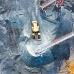
Canadian mapping software company SimActive has added additional capacity to be able to automatically assess multiple volumes of material (aggregates and other material) for projects and to report based upon the findings. If the same area is being flown, users can then compare the volumes and access differences over time. This allows companies to be able to better plan … [Read more...] about Simactive Works to Increase Value in Mining and Surveying Drone Market
From the Floor at Pix4D’s User Conference: Chris Anderson on Breaking the 1:1 Ratio in Drones

Pix4D's first annual User Conference kicked off today at the beautiful McNichols Civic Center in Denver, CO. CEO and founder Dr. Christophe Strecha opened the conference by telling a packed auditorium just how far 3D mapping and modeling has come since he first worked on the problem as a PhD candidate in Switzerland in the early 2000's. With over 78,000 users, 200 … [Read more...] about From the Floor at Pix4D’s User Conference: Chris Anderson on Breaking the 1:1 Ratio in Drones
Surveying with Drones: The Key Differences Between Aerial LiDAR and Photogrammetry
The following is a guest post from Dustin Price, licensed land surveyor and operations manager at Landpoint: a surveying, aerial data and technical services provider. There has been an influx of new and, in some cases, game-changing surveying technologies that have popped up over the past few years. Arguably the biggest of these technologies is unmanned aerial vehicles … [Read more...] about Surveying with Drones: The Key Differences Between Aerial LiDAR and Photogrammetry


