
SkyWatch has announced the addition of Spexi orthomosaic drone imagery to its platform, expanding access to standardized aerial data for mapping and analysis. The integration allows users to source ultra-high-resolution drone imagery directly through SkyWatch’s EXPLORE and HUB applications. With the launch, SkyWatch customers can access Spexi’s stitched, orthorectified imagery … [Read more...] about Spexi Orthomosaic Drone Imagery Now Available on SkyWatch Platform
mapping
From the Floor Of Intergeo 2025: GeoCue Announces NDAA-Compliant TrueView 641 Aerial LiDAR Sensor

GeoCue unveiled the TrueView 641 at INTERGEO 2025, a new NDAA-compliant aerial LiDAR sensor designed to meet growing demand from surveying and engineering companies across the United States and worldwide. The engineering-grade sensor addresses the increasing number of Federal, State, Local, and Educational contracts requiring NDAA compliance while maintaining cost accessibility … [Read more...] about From the Floor Of Intergeo 2025: GeoCue Announces NDAA-Compliant TrueView 641 Aerial LiDAR Sensor
Check Out These New Features in Global Mapper v25 from Blue Marble
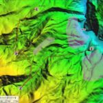
Top New Features in Global Mapper v25 Continue reading below, or listen: DroneLife · Blue - Marble - New - Features - Global - Mapper - Pro Blue Marble Geographic’s flagship software, Global Mapper Pro, is an all-in-one GIS package for analyzing and processing vector, terrain, image, and point cloud data. A comprehensive and easy-to-use GIS application that provides an … [Read more...] about Check Out These New Features in Global Mapper v25 from Blue Marble
The Skydio 2 Dock Aims to Make Fully Autonomous Workflows a Reality

Earlier this month the highly anticipated Skydio 2 landed, revamping the original R1 and sending a clear message to hobbyist drone pilots and professionals: You don't have to fly with DJI. Aside from all the bells and whistles of the new release - which include (still) unmatched computer vision, an improved camera, longer flight time, a crash guarantee, and a cheaper opening … [Read more...] about The Skydio 2 Dock Aims to Make Fully Autonomous Workflows a Reality
DJI Expands Mapping & Surveying Solutions

DJI has announced a raft of product news at the INTERGEO conference in Stuttgart, Germany. The updates from the drone industry's leading manufacturer are aimed at improving the company's surveying tools. DJI Updates Mapping & Surveying Solutions The new products and updates include: Matrice 210 RTK V2 + Zenmuse X7 A new package that combines a rugged aerial platform … [Read more...] about DJI Expands Mapping & Surveying Solutions


