
New integration enables fully automated drone operations for real-time mapping and analysis in the ArcGIS ecosyste FlytBase and Esri Announce Strategic Collaboration FlytBase, a global provider of autonomous drone software, has announced a new partnership with geographic information system (GIS) technology leader Esri. The collaboration enables full integration between … [Read more...] about FlytBase and Esri Partner to Streamline Drone Data into GIS Workflows
Esri
Esri Integrates Blue UAS Cleared Drone with ArcGIS Flight
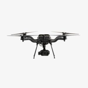
Freefly Systems' Astro Max Becomes First NDAA-Compliant Drone in Esri's Geospatial Application Esri has announced support for the Astro Max drone in its ArcGIS Flight application. The Astro Max, developed by Freefly Systems, is the first Blue UAS cleared and NDAA-compliant drone to integrate with the geospatial software1. Enhanced Capabilities for Government and Enterprise … [Read more...] about Esri Integrates Blue UAS Cleared Drone with ArcGIS Flight
Harnessing Geospatial Technology for Enhanced Emergency Response in Lincolnshire
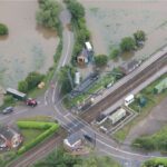
A Multi-Agency Approach to Disaster Management: From Flooding to Infrastructure Failures, Lincolnshire Resilience Forum Leverages Esri UK’s Real-Time Mapping Dashboard for Rapid Decision-Making and Community Resilience by DRONELIFE Staff Writer Ian J. McNabb The Lincolnshire Resilience Forum (LRF) recently adopted new technology from geospatial services firm Esri UK to … [Read more...] about Harnessing Geospatial Technology for Enhanced Emergency Response in Lincolnshire
Insitu Demonstrates Revolutionary UAV Integrated with GIS for Fighting Wildfires
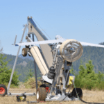
Boeing subsidiary Insitu, working with Esri, the spatial analytics firm, has successfully completed test flights on a method for supporting firefighting efforts using state-of-the-art software. The flights were held at the FAA's UAS Warm Springs, Oregon Test Range. The national FAA test site program facilitates the UAS industry in meeting strict customer needs and … [Read more...] about Insitu Demonstrates Revolutionary UAV Integrated with GIS for Fighting Wildfires
Insitu Partners with Esri and FireWhat on UAV Solution for Fire Fighting
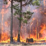
Insitu is partnering with FireWhat, and Esri to provide aerial reconnaissance for fighting wildfires. The solution will use Insitu’s ground control station (INEXA Control), drones (ScanEagle), and payloads including the High Accuracy Photogrammetry (HAP) payload. The Insitu team will work with FireWhat’s fire professionals, using its geographic information system (GIS) … [Read more...] about Insitu Partners with Esri and FireWhat on UAV Solution for Fire Fighting


