
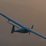
SimActive and Applanix Experts to Discuss the Role of High-Accuracy Positioning in Aerial Mapping Register for the Webinar:Thursday, June 12 | Two Live Sessions: 10 AM CET and 10 AM PSTRegister here SimActive will host a live interview on Thursday, June 12, bringing together two industry experts to explore the impact of advanced positioning systems on mapping accuracy. The … [Read more...] about Does Better Positioning Really Improve Mapping Accuracy?
drone mapping
Drone America and SpecTIR Partner to Expand Hyperspectral UAS Capabilities
Nevada-Based Companies Collaborate on Advanced Aerial Imaging for Government and Commercial Use A New Collaboration for Enhanced Aerial Sensing Drone America, a U.S. manufacturer of uncrewed aerial systems (UAS), and SpecTIR, a specialist in hyperspectral imaging technologies, have signed a new strategic agreement. The partnership will focus on delivering advanced aerial … [Read more...] about Drone America and SpecTIR Partner to Expand Hyperspectral UAS Capabilities
INTERGEO 2025 Opens Registration for World’s Largest Geospatial Tech Event

Frankfurt to Host Global Leaders in Mapping, UAV Innovation, and Smart City Solutions This October by DRONELIFE Staff Writer Ian J. McNabb INTERGEO, the world’s leading trade fair for geodesy, geoinformation, and land management, recently announced that ticket sales had begun for their flagship gathering to be held this October in Frankfurt Am Main. According to the … [Read more...] about INTERGEO 2025 Opens Registration for World’s Largest Geospatial Tech Event
3F Oil Palm Uses Drones to Improve Palm Plantation Yields in India
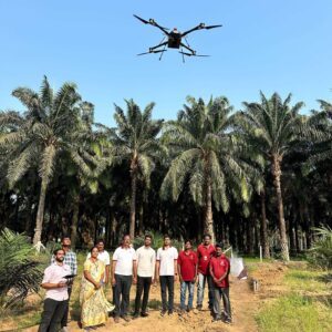
Pilot project in Andhra Pradesh surveys over 1,100 hectares to monitor tree health and estimate fruit production 3F Oil Palm Pvt Ltd has completed a major drone survey in Ayyavaram Village, West Godavari district, Andhra Pradesh. This pilot project marks a key step in using drone technology to support palm oil farmers across India. Over three days, drones flew over 800 … [Read more...] about 3F Oil Palm Uses Drones to Improve Palm Plantation Yields in India
Enhancing Drone Mapping with RTK and PPK: Insights from SimActive’s Eric Andelin

Drone mapping technology has advanced significantly in recent years, with Real-Time Kinematic (RTK) and Post-Processed Kinematic (PPK) positioning emerging as game-changing technologies. These methods enhance mapping accuracy and efficiency, reducing reliance on traditional Ground Control Points (GCPs). SimActive, a leading provider of photogrammetry software, offers powerful … [Read more...] about Enhancing Drone Mapping with RTK and PPK: Insights from SimActive’s Eric Andelin


