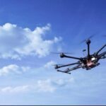
DRONELIFE recently caught up with Prateek Srivastava, CEO of Terra Drone India. As India becomes a major player in the global drone industry, Srivastava gives his take on the commercial drone industry, unmanned traffic management (UTM), and where he sees the commercial market going in India. DRONELIFE: Can you tell our readers who many not be familiar with Terra Drone what … [Read more...] about DroneLife Exclusive: CEO of Terra Drone India, Part of a Global Drone Powerhouse
Featured - Surveying
SimActive Expands its Partner Network for Medium Format Camera Solutions

SimActive Inc., recently announces the expansion of its network of resellers for medium format licenses. The new strategic alliances allow them to address the growing market need for processing imagery from medium format sensors. Partners include firms such as LiDARUSA, who offers SimActive’s Correlator3D™ to complement Phase One cameras. This announcement follows a recent … [Read more...] about SimActive Expands its Partner Network for Medium Format Camera Solutions
Yuneec Unveils RTK Satellite Navigation For H520 Drone
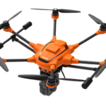
Drone manufacturer Yuneec has announced that its commercial hexacopter, the H520, will now be optionally available with an RTK (Real Time Kinematic) system. The addition of the RTK system from Swiss company Fixposition, means that even under difficult GPS conditions - in dense urban areas or canyons, for example - pilots and aerial data gatherers can benefit … [Read more...] about Yuneec Unveils RTK Satellite Navigation For H520 Drone
Conservation: Using Drones to Stem The Plastic Tide

An environmental organization in England is using drones and artificial intelligence to help measure plastic waste on the world's beaches. In the last 10 years, there has been a 250% increase of plastics washing up on the world's beaches. Of the millions of tons that are dumped in our oceans each year, we can only account for around 1%. The rest - yes, that's 99% of millions … [Read more...] about Conservation: Using Drones to Stem The Plastic Tide
Endurance Flight without a Helicopter: Drone Tech Firm Harris Aerial Demonstrates LiDAR with Carrier H4 Hybrid
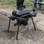
Aerial LiDAR surveys aren't new technology - but now U.S. - based Harris Aerial has demonstrated a new and ground-breaking way of performing them. LiDAR surveys provide critically accurate survey data, allowing for the creation of precise 3D models. LiDAR attached to a helicopter or other manned aircraft have been used for over 50 years in applications like natural hazard … [Read more...] about Endurance Flight without a Helicopter: Drone Tech Firm Harris Aerial Demonstrates LiDAR with Carrier H4 Hybrid


