Guest post by Ian Smith, DroneDeploy —
The information below was given to us during an interview with DroneDeploy user Derek P. who operates an AgEagle drone for his business, an agricultural services company in North Dakota. Derek has accumulated nearly 30 successful flights in his first growing season with DroneDeploy.
Click and open the below map in a new tab to explore and reference it for the purposes of this case study:
The story
Every year, potato growers need to create projections on how much yield they think their crops will give them. The growers use these projections to plan for themselves but also give those same projections to their wash house so that they can plan as well.
The wash house is where the potatoes go to be cleaned and packaged, then distributed for consumption to the public. The wash house needs the yield projections from the grower in order to optimize their work to come.
These projections are critical to both parties.
The clearly defined horizontal line shown on the NDVI reference map (linked to above) shows the purposeful division between two different types of potatoes that the grower (Derek’s client) had planted in order to determine which varietal he would choose to grow for the next growing season — a potato ‘trial by fire’, if you will.
Each potato type has their own strengths and weaknesses. In this field, the northern section is a potato which doesn’t withstand storage very well and the southern section is a potato varietal that typically lasts longer in storage.
The information gathered from the results on the reference map that Derek created will be used in planning for the next season’s grow. May the best potato win.

Every minute of work that the grower and wash house can shave off is extra money in their pockets — it is a constant quest for absolute optimization.
The flight
The 150 acre potato field in this case study was mapped by Derek using an AgEagle (fixed-wing drone) powered by DroneDeploy and is just one of many fields that make up a very large farming operation in North Dakota (thousands upon thousands of acres in total size).
Using the DroneDeploy mobile app and his fingertips, Derek resized a square over the potato field which indicated the area he wanted to map with his drone — the flight plan was then automatically generated for him, based on that square, in less than a second:

After verifying the flight plan, Derek pressed one button on his DroneDeploy app which launched the AgEagle into the air from its mechanical launcher on the ground. The rest of the flight was completely automated.
As images were taken from the AgEagle they were automatically beamed via 4G into the cloud, where the powerful DroneDeploy map engine stitched together the photos in real-time to create a map. As the real-time photo stitching happened, the results were immediately available on Derek’s mobile device.
Total flight time, ~20 minutes.
Before the AgEagle even landed, Derek had preliminary map results available on the DroneDeploy app (called a ‘fast-stitch’).
The AgEagle finished its flight and automatically landed in the pre-determined LZ that Derek had specified.
30 minutes after landing, while still in the field, Derek had the fully-stitched, high-resolution map of the potatoes at his fingertips.
Total image processing time, ~30 minutes.
Analyzing the data
The day that this map was created was just a couple days after a large rain storm hit the area.
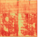
Entire picture
The large red areas shown on this NDVI map signify water damage that the potatoes had sustained from the storm that had passed through a couple days earlier.
The red areas (circled below) show parts of the field that will not produce useable potatoes whereas the green and yellow areas should still produce:

This map showed Derek and the grower that the northern section of potatoes resisted the large amount of rainfall much more efficiently than the southern section.
Medium zoom
Zooming in another level, Derek and the grower were alerted to an additional issue — the planting machine had malfunctioned.
The horizontal red stripes in the map are sections that show how, unbeknownst to the grower, his planting machine malfunctioned in those areas:

Full zoom
Upon zooming all the way in to the map, levels of detail were revealed that would never have been seen unless the grower went out and examined the entire field on foot himself.
Even more alarming than the fairly obvious planter malfunction above ; its settings were miscalibrated which negatively affected the consistency of planted potatoes for each row of potatoes on the entire field:

Projections
Derek took his DroneDeploy data a step further and got the grower enhanced yield projection values (a feature that is coming soon to DroneDeploy):


The northern section (lower shelf-life varietal; roughly 40% of the total sample size) had proportionately less red area than the southern section (higher shelf-life varietal; roughly 60% of the total sample size).
This analysis proved to the grower that he lost 27% (40.6 acres) of this entire test crop to rain.
According to various reports from 2007 and 2009 (USDA, Washington State University, BDO Canada), the average cost to produce an acre of potatoes is between $2,000-$3,000 (at a yield production rate of up to 61,000 pounds per acre) with the average sale price being $4,000+ per acre.
Based on the above, this means that the 40.6 acre loss of potatoes in this case study is worth over $160,000 to the grower.
Savings
Just one drone flight allowed the grower to save time and money.
Time

By using a drone to map his field, the grower saved at least 72 hours of his own time that normally would’ve been wasted, spent waiting to receive results. Having to wait days (or even weeks) for drone maps to be delivered to you is a common occurrence with other solutions.
Another option would have been to go by foot or ATV to scout his crops but that could take the entire day and he still wouldn’t have the full picture.
Growers need same-day data.
Money

In pursuit of alternate methods, we contacted Apollo Mapping to learn the cost to use satellites for acquiring a map of the same area that Derek captured. Their prices begin at $2,300 for just one single-time image.
We also contacted American Images to learn the cost of using a small airplane to acquire a map of the same area. Their prices begin at $300 per photo but are extremely limited: they cannot do straight-down (nadir) shots, infrared images (so no NDVI possibility), can’t give turnaround the same day, and can’t even give the same high-resolution result that low-flying drones can.
Furthermore, none of these traditional solutions (or those of DroneDeploy’s direct competitors) give the user the ability to easily view or share their data anywhere in the world on just a web browser.
With a potential net loss of $160,000 of potato revenue to the grower, having the ability to cut that down by even just 10% would allow him to recoup $16,000 in lost revenue during next year’s growing season.
Keeping in mind that this field is less than 1% of the entire, massive growing operation, a 27% potato-loss on the operation’s total area (10,000+ acres @ $4,000/acre) is worth north of $40 million.
It took Derek less than 60 minutes of his time from ‘takeoff’ to ‘data in-hand’ and the only direct cost for operating the drone was the cost of charging its batteries —pennies that go unnoticed, tacked onto his electricity bill.

Interested in AgEagle? For price inquiries, click here — every AgEagle has a 12-month DroneDeploy subscription included in the price.
The takeaway
After viewing the information acquired by the drone, the grower made four key decisions:
- Even though they don’t have as long of a shelf-life as the southern section variety, next growing season the grower will be planting the variety of potatoes from the northern section of his field since they resist water much better.
- He has identified that his planting machine needs an upgrade to fix the error of missing entire rows of missing potatoes.
- His planting machine’s settings need to be updated and recalibrated in order to maximize every inch of his field so that the gaps between potatoes are minimized.
- The aerial NDVI imagery provided by DroneDeploy enabled him to make very accurate yield projections for himself and the wash house, so the overall efficiency of the operation will rise.
In one single flight of his drone, Derek provided the grower with four valuable pieces of same-day information. This information allowed the grower to make critical decisions immediately and have the potential to save him over $16,000 next growing season.
Ian Smith, Sales & Marketing @DroneDeploy
Frank Schroth is editor in chief of DroneLife, the authoritative source for news and analysis on the drone industry: it’s people, products, trends, and events.
Email Frank
TWITTER:@fschroth


Leave a Reply