• Skip to main content
  • Skip to secondary menu
  • Skip to primary sidebar
  • Skip to secondary sidebar
  • Skip to footer
  • DroneRacingLife
  • DroneFlyers
  • Newsletter
DroneLife

DRONELIFE

Stay up to date on all the latest Drone News

  • News
  • Products
  • Industries
    • Agriculture
    • Construction
    • Delivery
    • Dual Use
    • Inspection
    • Public Safety
    • Surveying
  • Enthusiasts
  • Regulations
  • Business
  • Video
  • Podcasts

Designing Resilient Roads on Java’s Southern Coast: A Blue Marble Geographics Case Study

February 26, 2026 by Miriam McNabb Leave a Comment

As governments invest in infrastructure to unlock tourism and regional growth, the challenge is no longer just building roads. It is building roads that can endure terrain, climate, and time.

A recent case study from Blue Marble Geographics demonstrates how drone-based photogrammetry and watershed modeling are helping engineers design a more resilient transportation corridor along Indonesia’s southern coast.

Blue Marble’s Global Mapper Pro® is a powerful all-in-one GIS software platform designed to unify advanced spatial data processing, lidar and photogrammetric workflows, terrain analysis, and hydrologic modeling within a single environment. With specialized tools such as the Pixels to Points® photogrammetric module, robust point cloud handling, and extensive format support, Global Mapper Pro empowers engineers and geospatial professionals to turn drone and GIS data into actionable insights.

A Strategic Corridor Through Volcanic Terrain

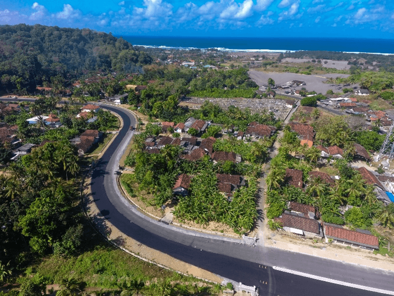
Java Island is home to nearly half of Indonesia’s population and its capital, Jakarta. While the northern coastline has long served as a commercial hub, the southern coast remains more rural. In recent years, however, its volcanic landscapes and beaches have drawn increasing tourism interest.

To support development in Indonesia’s National Tourism Strategic Areas, the government is constructing the South Coast Road, known as Jalur Lintas Selatan Jawa. The corridor links major cities such as Yogyakarta with airports and coastal destinations.

Completed segments have already reduced travel times from approximately seven hours to two. That shift has strengthened tourism access and supported regional economic growth.

resilient road design

One critical segment, the Jalan Kretek–Girijati Road, connects Yogyakarta International Airport, Adisutjipto Airport, Yogyakarta City, and popular southern coastal areas. The contractor, PT Waskita Karya (Persero) Tbk, faced a complex design environment defined by steep terrain, variable elevations, and intense seasonal rainfall.

In this setting, landslides, erosion, and localized flooding present real risks. Designing a roadway that works with natural drainage patterns is essential for long-term stability and safety.

Turning Drone Imagery into Terrain Intelligence: The Real World Workflow

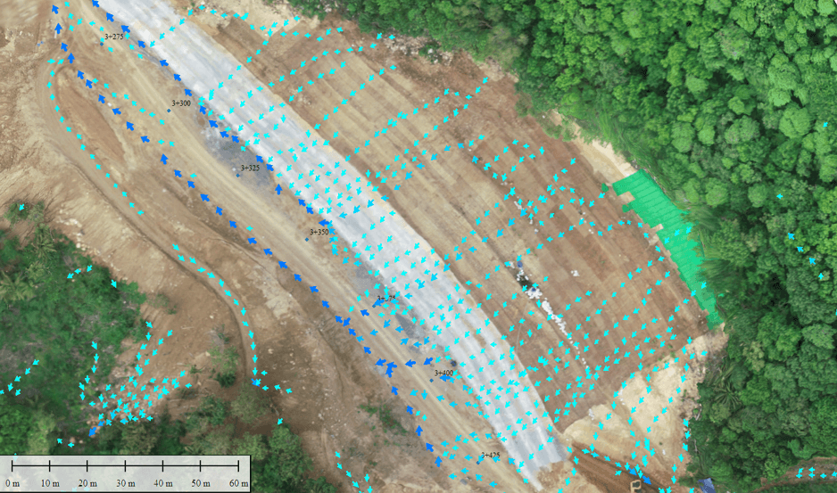
The workflow begins with high-resolution aerial imagery collected by drones. Surveyed ground control points ensure positional accuracy.

Within Global Mapper Pro, Blue Marble’s photogrammetric module, Pixels to Points®, processes the imagery into 3D point clouds, digital elevation models, and seamless orthophotos. These outputs form an accurate representation of site conditions and provide the foundation for further analysis.

For infrastructure projects in rugged terrain, detailed elevation models enable engineers to assess slope conditions, evaluate cut-and-fill requirements, and understand surface behavior at a granular level. The resulting terrain intelligence becomes central to responsible design.

Modeling Watersheds to Reduce Risk

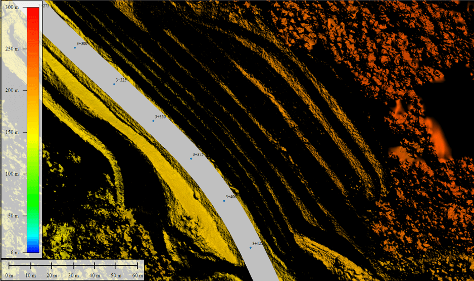
Once a terrain model is generated, hydrologic analysis begins.

Using Global Mapper’s watershed tools, the project team evaluates surface water flow paths, runoff patterns, and catchment areas. In southern Java’s high-rainfall environment, understanding how water moves across slopes is critical.

Watershed modeling highlights areas where water may concentrate during heavy storms. These zones often correlate with potential hazards, including landslides, surface erosion, and water pooling.

By integrating drone-derived elevation data with hydrologic modeling, engineers can adjust road alignments, drainage placement, and earthwork strategies before construction progresses too far. Instead of reacting to storm damage after the fact, the design process anticipates risk.

Integrating Internal Project Data

Infrastructure design relies on more than terrain data alone.

PT Waskita Karya maintains internal spatial datasets, including stationing points, road alignments, project boundaries, and right-of-way limits. Through Global Mapper’s Online Data Sources tool, the team connects to custom Web Map Services and overlays these authoritative datasets with terrain and watershed outputs.

This integrated environment allows engineers to visualize how proposed road geometry interacts with slope conditions and hydrologic patterns. Both 2D and 3D views support clearer communication across design and construction teams.

By consolidating imagery, elevation data, watershed outputs, and project GIS layers in one platform, the workflow reduces fragmentation and improves decision-making efficiency.

Field Validation Confirms the Analysis

The photogrammetric and watershed analysis of the Jalan Kretek–Girijati corridor identified several areas with high potential for surface water accumulation.

Following a significant rainfall event, the team conducted ground observations. Water pooling occurred in the same locations predicted by the model.

With that validation, the project team implemented targeted drainage enhancements and slope stabilization measures. These preventative actions reduced the likelihood of landslides and flooding while helping protect nearby communities and sensitive environments.

A Repeatable Model for Resilient Infrastructure

The Jalan Kretek–Girijati project illustrates how drone-based photogrammetry and watershed modeling can support sustainable infrastructure development in complex terrain.

By combining aerial data collection, detailed terrain modeling, hydrologic analysis, and integrated GIS overlays, the workflow enables engineers to anticipate environmental challenges before they become construction delays or safety risks.

As Indonesia continues expanding its southern coastal corridor, this approach provides a repeatable framework for resilient road design. It also highlights the expanding role of drone data and geospatial analysis in large-scale infrastructure planning.

For more information on Global Mapper Pro® and how its integrated toolset supports workflows like this, visit Blue Marble Geographics.

Read more:

  • Blue Marble Shows How AI and LiDAR Deliver ROI for Rail Operators
  • Blue Marble Geographics Unveils Global Mapper® v26.2 at Intergeo 2025
  • Drone Mapping Transforms Police Crash Investigations: A Blue Marble Geographics Case Study
Miriam McNabb

Miriam McNabb is the Editor-in-Chief of DRONELIFE and CEO of JobForDrones, a professional drone services marketplace, and a fascinated observer of the emerging drone industry and the regulatory environment for drones. Miriam has penned over 3,000 articles focused on the commercial drone space and is an international speaker and recognized figure in the industry.  Miriam has a degree from the University of Chicago and over 20 years of experience in high tech sales and marketing for new technologies.
For drone industry consulting or writing, Email Miriam.

TWITTER:@spaldingbarker

Subscribe to DroneLife here.

Filed Under: Applications, DL Exclusive, Drone News, Drone News Feeds, Mapping, Mapping Technology, News Tagged With: 3D point clouds, Blue Marble Geographics, DEM generation, drone mapping, drone photogrammetry, geospatial analysis, GIS software, Global Mapper Pro, hydrologic analysis, Indonesia infrastructure, infrastructure mapping, resilient road design, road construction technology, terrain modeling, watershed modeling

Reader Interactions

Leave a Reply Cancel reply

Your email address will not be published. Required fields are marked *

Primary Sidebar

LATEST

DroneShield Integrates Robin Radar for Layered Drone Airspace Protection

DroneShield has announced a new partnership with Robin Radar Systems to expand its counter-UAS sensor ecosystem. The agreement integrates Robin’s…

Continue Reading DroneShield Integrates Robin Radar for Layered Drone Airspace Protection

Warren County Community College Launches Counter-Drone Security Training Program

New curriculum will train students and professionals to identify and respond to drone threats Warren County Community College (WCCC) in…

Continue Reading Warren County Community College Launches Counter-Drone Security Training Program

Drone Warfare Expertise Is Becoming a Global Export Industry

A review of today’s international news reveals a growing market for drone warfare knowledge and counter-UAS technology A review of…

Continue Reading Drone Warfare Expertise Is Becoming a Global Export Industry

FAA’s DiSCVR System Helps Law Enforcement Identify Drones in Flight

New FAA data tool connects Remote ID broadcasts with registration and airspace authorization records As drone use continues to grow…

Continue Reading FAA’s DiSCVR System Helps Law Enforcement Identify Drones in Flight

National League of Cities and BRINC Launch National Drone as First Responder Initiative

Partnership aims to help cities deploy drones to 911 calls and modernize emergency response The National League of Cities (NLC)…

Continue Reading National League of Cities and BRINC Launch National Drone as First Responder Initiative

AeroVironment Acquires ESAero in $200M Deal, Expanding Engineering Capabilities for Defense and Autonomous Aircraft

Acquisition adds advanced aircraft design and manufacturing expertise as the defense drone industry continues to consolidate. U.S. drone manufacturer AeroVironment…

Continue Reading AeroVironment Acquires ESAero in $200M Deal, Expanding Engineering Capabilities for Defense and Autonomous Aircraft

Vector, SR2 to Localize Attritable Drone Systems in Saudi Arabia

Vector and Saudi Arabia’s SR2 Defense Systems have signed a Memorandum of Understanding (MoU) to localize production of attritable drone…

Continue Reading Vector, SR2 to Localize Attritable Drone Systems in Saudi Arabia

Apellix Names Drone Clean UK as Exclusive Cleaning Drone Distributor

Apellix has named Drone Clean UK as the exclusive distributor for its autonomous cleaning drones in the United Kingdom. The…

Continue Reading Apellix Names Drone Clean UK as Exclusive Cleaning Drone Distributor

DOT and FAA Launch eVTOL Integration Pilot Program

By Dronelife Features Editor Jim Magill Although the future of jet-propelled cars whizzing across the sky, as portrayed in The…

Continue Reading DOT and FAA Launch eVTOL Integration Pilot Program

FDNY Explores Convergence of Robotics for Public Safety Operations

At DRONERESPONDERS conference, FDNY’s Mike Leo discusses integrating drones, ground robots, and other robotic systems to improve situational awareness Public…

Continue Reading FDNY Explores Convergence of Robotics for Public Safety Operations

Secondary Sidebar

Footer

SPONSORED

Inspired Flight Gremsy IF800 VIO F1 drones geo week

What Will It Take to Strengthen U.S. Drone Manufacturing? A Conversation with Inspired Flight’s CEO

Global Mapper Mobile data collection

Collection Ground Control Points with Global Mapper Mobile

Military Drone Mapping Solutions

How SimActive’s Correlator3D™ is Revolutionizing Military Mapping: An Exclusive Interview with CEO Philippe Simard

Photogrammetry Accuracy Standards

SimActive Photogrammetry Software: Enabling Users to Meet Accuracy Standards for Over 20 Years

NACT Engineering Parrot ANAFI tether indoor shot

Smart Tether for Parrot ANAFI USA from NACT Engineering

Blue Marble, features global mapper, features Blue Marble

Check Out These New Features in Global Mapper v25 from Blue Marble

About Us | Contact Us | Advertise With Us | Write for Us | Privacy Policy | Terms of Service

The Trusted Source for the Business of Drones.

This website uses cookies and third party services. By clicking OK, you are agreeing to our privacy policy. ACCEPT

Manage consent

Privacy Overview

This website uses cookies to improve your experience while you navigate through the website. Out of these, the cookies that are categorized as necessary are stored on your browser as they are essential for the working of basic functionalities of the website. We also use third-party cookies that help us analyze and understand how you use this website. These cookies will be stored in your browser only with your consent. You also have the option to opt-out of these cookies. But opting out of some of these cookies may affect your browsing experience.
Necessary
Always Enabled
Necessary cookies are absolutely essential for the website to function properly. These cookies ensure basic functionalities and security features of the website, anonymously.
CookieDurationDescription
cookielawinfo-checkbox-analytics11 monthsThis cookie is set by GDPR Cookie Consent plugin. The cookie is used to store the user consent for the cookies in the category "Analytics".
cookielawinfo-checkbox-functional11 monthsThe cookie is set by GDPR cookie consent to record the user consent for the cookies in the category "Functional".
cookielawinfo-checkbox-necessary11 monthsThis cookie is set by GDPR Cookie Consent plugin. The cookies is used to store the user consent for the cookies in the category "Necessary".
cookielawinfo-checkbox-others11 monthsThis cookie is set by GDPR Cookie Consent plugin. The cookie is used to store the user consent for the cookies in the category "Other.
cookielawinfo-checkbox-performance11 monthsThis cookie is set by GDPR Cookie Consent plugin. The cookie is used to store the user consent for the cookies in the category "Performance".
viewed_cookie_policy11 monthsThe cookie is set by the GDPR Cookie Consent plugin and is used to store whether or not user has consented to the use of cookies. It does not store any personal data.
Functional
Functional cookies help to perform certain functionalities like sharing the content of the website on social media platforms, collect feedbacks, and other third-party features.
Performance
Performance cookies are used to understand and analyze the key performance indexes of the website which helps in delivering a better user experience for the visitors.
Analytics
Analytical cookies are used to understand how visitors interact with the website. These cookies help provide information on metrics the number of visitors, bounce rate, traffic source, etc.
Advertisement
Advertisement cookies are used to provide visitors with relevant ads and marketing campaigns. These cookies track visitors across websites and collect information to provide customized ads.
Others
Other uncategorized cookies are those that are being analyzed and have not been classified into a category as yet.
SAVE & ACCEPT