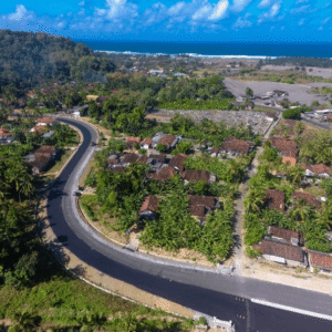
As governments invest in infrastructure to unlock tourism and regional growth, the challenge is no longer just building roads. It is building roads that can endure terrain, climate, and time. A recent case study from Blue Marble Geographics demonstrates how drone-based photogrammetry and watershed modeling are helping engineers design a more resilient transportation corridor … [Read more...] about Designing Resilient Roads on Java’s Southern Coast: A Blue Marble Geographics Case Study
geospatial analysis
Managing Large Photogrammetry Projects Simultaneously: Can It Be Done?

How scalable workflows, automation, and distributed processing make managing large photogrammetry projects possible. DRONELIFE spoke with Philippe Simard, co-founder and CEO of SimActive, the Canadian company behind the Correlator3D photogrammetry suite, to explore one of the most pressing challenges in the aerial mapping industry: how to efficiently manage and process … [Read more...] about Managing Large Photogrammetry Projects Simultaneously: Can It Be Done?


