New Update Introduces Deep Learning Model Fine-Tuning and Improved Point Cloud Processing
Blue Marble Geographics has released Global Mapper v26.1, introducing enhancements to its geographic information system (GIS) software. This update refines point cloud processing, expands deep learning capabilities, and improves customization options for users.
Global Mapper is an all-in-one GIS software solution driven by innovation, accessibility, and user feedback. The standard version provides users with tools for vector, raster, and terrain analysis. Global Mapper Pro® expands upon these tools to unlock terrain painting, photogrammetry, lidar analysis including: automatic point cloud classification and feature extraction, along with Python scripting and more.
Streamlined User Experience and Customization
 Version 26.1 focuses on improving usability and workflow efficiency. The update consolidates the Digitizer toolbar buttons into a dedicated toolset. A similar toolset in Global Mapper Pro enhances the Manual Classification of Point Clouds, making classification more intuitive. A new Scripting toolbar provides quick access to script creation, editing tools, and a Favorite Scripts option for rapid execution of Global Mapper and Python scripts. Additional usability improvements include explicit camera positioning in the 3D Viewer and the ability to save text file import options for future use.
Deep Learning Enhancements and Vehicle Detection Fine-Tuning
Advancements in machine learning and deep learning further expand the software’s capabilities. “This latest release includes exciting new updates to our AI-based tools,” states Product Manager, Jeff Hatzel. “We have expanded our machine learning-based point cloud classification methods to include powerlines. Additionally, we have updated the Insight and Learning Engine’s deep learning image analysis tools with vehicle detection fine-tuning and custom model sharing.”
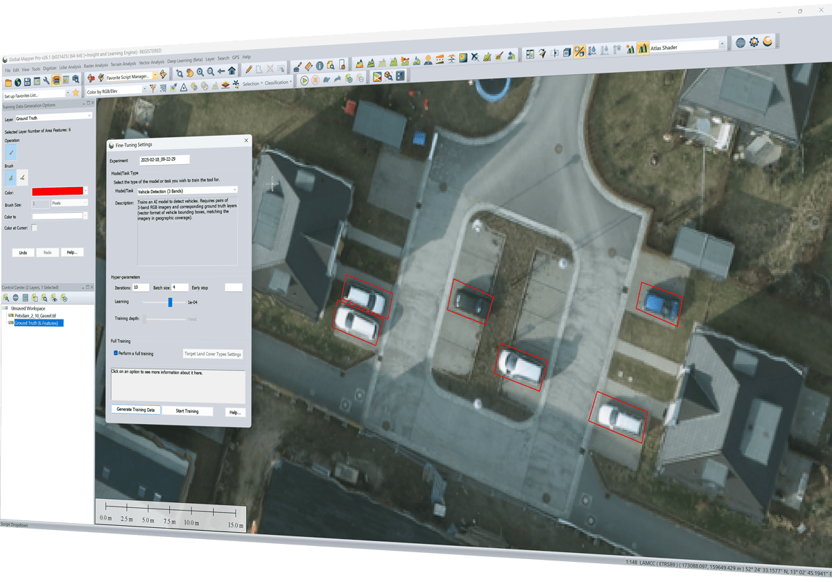
Users of Global Mapper Pro v26.1 can continue accessing the beta version of the Insight and Learning Engine. A dedicated configuration panel allows users to work with the latest models from Blue Marble Geographics and share custom models created through fine-tuning and retraining. The vehicle detection model can now be adjusted using tools for creating training data, enhancing precision in deep learning applications.
Expanded Point Cloud Data Management
The latest update introduces segmentation-based classification for powerline identification and extends the Split Layers tool. Users can now divide point clouds into layers based on classification, point source ID, or return number. Enhancements to the Lidar QC tool allow for removing outlier control points after initial comparisons. Additionally, the Pixels to Points® drone and UAV image analysis tool now includes color harmonization options, improving the quality of photogrammetric outputs.
Learning Resources for Photogrammetry Tools
For users seeking to improve their understanding of Global Mapper Pro’s photogrammetry tools, the Blue Marble Geographics Online Classroom now offers a new Pixels to Points course. The course provides guided workflows covering essential features such as ground control points, drone image uploads, point cloud and orthoimage generation, and ground point classification for elevation grid creation.
Availability and Additional Information
Global Mapper v26.1 is available now, offering user-friendly improvements that support workflows across multiple industries. To explore the new features, download a trial version, or learn more, visit www.bluemarblegeo.com/global-mapper-pro.
Want DRONELIFE news delivered to your inbox every weekday? Sign up here.
Read more:
- Check Out These New Features in Global Mapper v25 from Blue Marble
- Creating 3D Data with Pixels to Points in Global Mapper Pro
- 2025 Drone Industry Predictions: What’s Coming Next in Policy, Tech, and Global Markets

Miriam McNabb is the Editor-in-Chief of DRONELIFE and CEO of JobForDrones, a professional drone services marketplace, and a fascinated observer of the emerging drone industry and the regulatory environment for drones. Miriam has penned over 3,000 articles focused on the commercial drone space and is an international speaker and recognized figure in the industry. Miriam has a degree from the University of Chicago and over 20 years of experience in high tech sales and marketing for new technologies.
For drone industry consulting or writing, Email Miriam.
TWITTER:@spaldingbarker
Subscribe to DroneLife here.


Leave a Reply