• Skip to main content
  • Skip to secondary menu
  • Skip to primary sidebar
  • Skip to secondary sidebar
  • Skip to footer
  • DroneRacingLife
  • DroneFlyers
  • Newsletter
DroneLife

DRONELIFE

Stay up to date on all the latest Drone News

  • News
  • Products
  • Industries
    • Agriculture
    • Construction
    • Delivery
    • Dual Use
    • Inspection
    • Public Safety
    • Surveying
  • Enthusiasts
  • Regulations
  • Business
  • Video
  • Podcasts

SPH Engineering Unveils Circlegrammetry: A New Approach to Drone Photogrammetry

October 15, 2024 by Miriam McNabb Leave a Comment

New tool promises faster, more accurate 3D models with shorter flight times

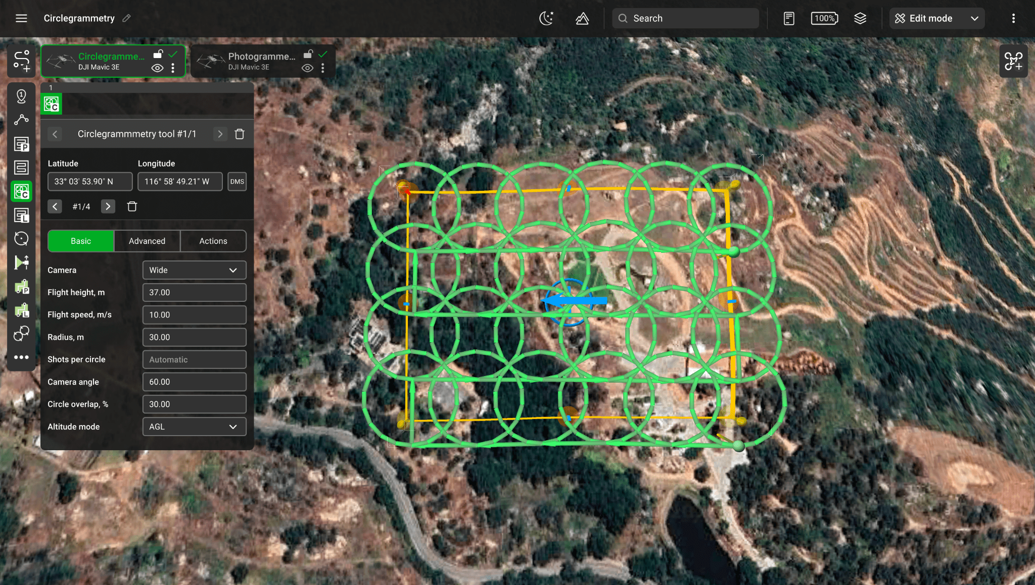
SPH Engineering has introduced Circlegrammetry, a new photogrammetry tool that could change how drone operators capture data for 3D modeling and mapping. Designed in response to challenges faced by drone pilots, Circlegrammetry aims to improve the accuracy, speed, and efficiency of aerial mapping projects.

A New Flight Pattern

Traditional drone photogrammetry often relies on grid or double-grid flight patterns. These methods can be time-consuming and may struggle to capture every necessary angle, leading to less-detailed 3D models. Circlegrammetry takes a different approach by introducing circular flight paths with camera angles set between 45 and 70 degrees toward the center of each circle. This innovative method allows for more angles to be captured in fewer flights.

circlegrammetry drone photogrammetry tool

“Circlegrammetry solves this by introducing an innovative algorithm that transforms the way drones capture imagery,” SPH Engineering explains.

By flying in circular patterns rather than grids, drones can capture data from more angles, ensuring higher accuracy in 3D modeling. This technique is especially effective for mapping complex geometries and vertical structures.

Efficiency Gains

One of the key benefits of Circlegrammetry is the reduction in flight times. Drones following the circular patterns can gather data more quickly than traditional grid-based missions. The overlapping orbits reduce the need for multiple flights, which means pilots can complete their tasks faster without sacrificing data quality.

“Circlegrammetry reduces the need for multiple grid-based missions, enabling faster flights while maintaining high-quality data,” according to SPH Engineering.

circlegrammetry drone photogrammetry tool
Results from a standard oblique area scan (double-grid) planned in DJI Pilot 2. Altitude: 37 meters, processed in Metashape.
Circlegrammetry drone photogrammetry tool
Results from a Circlegrammetry mission planned in UgCS software. Altitude: 37 meters, processed in Metashape using identical settings.

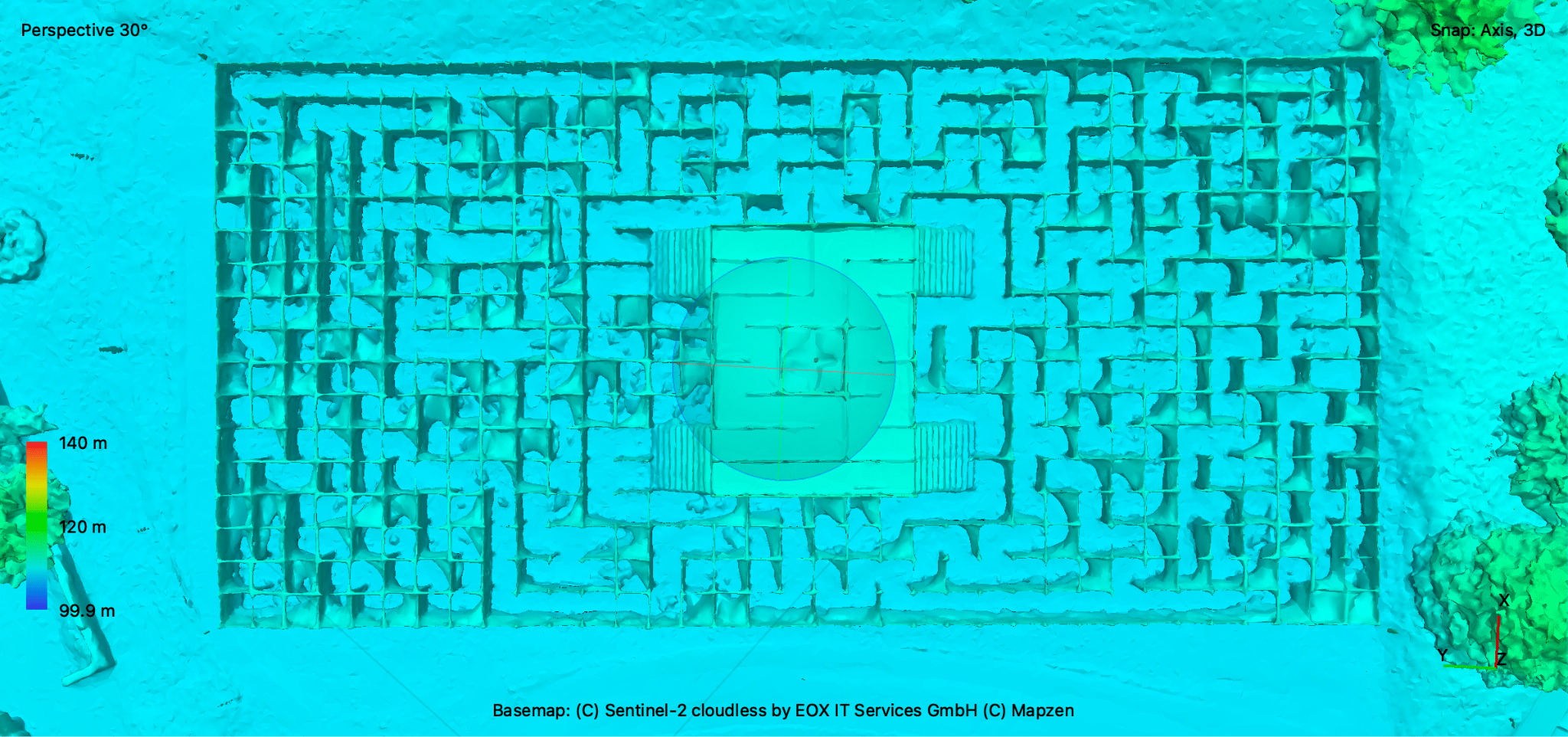
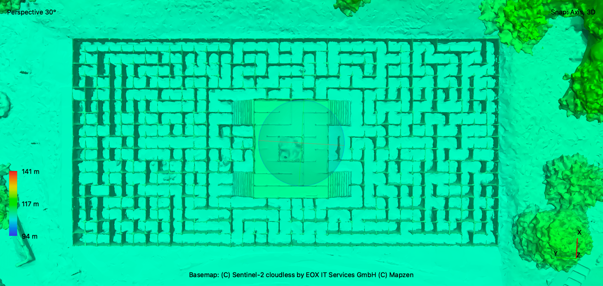
In addition to shorter flight times, Circlegrammetry also cuts down on the amount of redundant data collected, minimizing the processing load required after the flight. Fewer overlapping images lead to faster processing times, speeding up the entire workflow from data capture to final model creation.

Adapting to Low Altitudes

Another challenge that traditional methods face is flying at low altitudes, especially in areas with obstacles like trees or buildings. Circlegrammetry allows drones to operate safely at lower altitudes while still capturing high-quality data. SPH Engineering notes that double-grid oblique missions often force drones to fly outside the target area to avoid obstacles, which isn’t always feasible. Circlegrammetry, however, allows for detailed data collection at altitudes as low as 20 meters, without the risk of collision.

A Valuable Tool for Multiple Industries

Circlegrammetry is expected to be particularly useful in industries like construction, environmental monitoring, and asset inspection, where capturing fine details is critical. Whether it’s monitoring a construction site or mapping a dense forest, this tool offers significant advantages over traditional methods.

The tool is included in the latest UgCS 5.5 software release, and SPH Engineering is encouraging drone operators to take advantage of a free trial to experience the benefits of Circlegrammetry firsthand.

“Experience the power of this revolutionary tool today with a free trial and see firsthand how it transforms drone photogrammetry, delivering faster, more accurate results,” invites SPH Engineering.

For more information, visit SPH Engineering’s website to explore the features of Circlegrammetry and download the latest version of UgCS.

Read more:

  • SPH Engineering Unveils Romantic Drone Animation Sets for Valentine’s Day Celebrations
  • The Winners of SPH Engineering’s 4th International Drone Show Competition!
  • Universal Ground Control Software Now Available From SPH Engineering
Miriam McNabb

Miriam McNabb is the Editor-in-Chief of DRONELIFE and CEO of JobForDrones, a professional drone services marketplace, and a fascinated observer of the emerging drone industry and the regulatory environment for drones. Miriam has penned over 3,000 articles focused on the commercial drone space and is an international speaker and recognized figure in the industry.  Miriam has a degree from the University of Chicago and over 20 years of experience in high tech sales and marketing for new technologies.
For drone industry consulting or writing, Email Miriam.

TWITTER:@spaldingbarker

Subscribe to DroneLife here.

Filed Under: Applications, Drone News, Drone News Feeds, News Tagged With: 3d mapping, 3D modeling, aerial mapping, Circlegrammetry, drone data capture, drone photogrammetry, Drone Technology, photogrammetry tool, SPH Engineering, UgCS software

Reader Interactions

Leave a Reply Cancel reply

Your email address will not be published. Required fields are marked *

Primary Sidebar

LATEST

Aeronext Unveils ActiveWing Logistics Drone Prototype for Long-Range Delivery

This article published in collaboration with JUIDA, the Japan UAS Industrial Development Association.     The Tokyo company’s new multicopter pairs…

Continue Reading Aeronext Unveils ActiveWing Logistics Drone Prototype for Long-Range Delivery

FBI, Atlanta PD Stress Need for ‘No-Drone Zone’ Compliance

By Dronelife Features Editor Jim Magill (Editor’s note: This story is part of a series of reports on efforts to…

Continue Reading FBI, Atlanta PD Stress Need for ‘No-Drone Zone’ Compliance

Building a Resilient Supply Chain: Regional Security Leaders Focus on Industrial Readiness

Northeast National Security Conference examines how the U.S. can strengthen its defense industrial base Supply chain security has become a…

Continue Reading Building a Resilient Supply Chain: Regional Security Leaders Focus on Industrial Readiness

Defense Leaders Call for Faster Paths from Innovation to the Field

Remarks at the Northeast National Security Conference highlight growing demand for rapid, commercially informed defense solutions The 2026 Northeast National…

Continue Reading Defense Leaders Call for Faster Paths from Innovation to the Field

Collective Defence Acquires Asterion in $1 Billion Deal Combining Cybersecurity and Counter-Drone Technology

Transaction creates Luxembourg’s first defense unicorn and brings together cyber defense and combat-tested counter-UAS capabilitie Collective Defence has announced its…

Continue Reading Collective Defence Acquires Asterion in $1 Billion Deal Combining Cybersecurity and Counter-Drone Technology

Vantis BVLOS System Adds New Partner, FAA Waiver Across 5,000 Square Miles

A new FAA aircraft-agnostic waiver lets Frontier Precision fly any NDAA-compliant drone under 55 pounds across more than 5,000 square…

Continue Reading Vantis BVLOS System Adds New Partner, FAA Waiver Across 5,000 Square Miles

MatrixSpace Validated in U.S. Army’s Operation Jailbreak Integration Sprint

The portable radar maker’s integration with Anduril Lattice and IBCS-M passed Army validation at Fort Carson, joining 55 companies in…

Continue Reading MatrixSpace Validated in U.S. Army’s Operation Jailbreak Integration Sprint

Army Medical Brigade Expands Drone Use for Battlefield Resupply

New training program helps medical personnel deliver critical supplies faster while reducing risk to soldiers The U.S. Army’s 44th Medical…

Continue Reading Army Medical Brigade Expands Drone Use for Battlefield Resupply

Counter-Drone Partnership Sends Ouster Shares Higher as Investors Focus on Airspace Security

Lidar company’s agreement with German counter-UAS firm highlights growing market for drone detection and interception technologies Shares of lidar manufacturer…

Continue Reading Counter-Drone Partnership Sends Ouster Shares Higher as Investors Focus on Airspace Security

Airport Drone Closures Raise a Bigger Question: What Do Authorities Actually Know?

Recent airport disruptions highlight a growing challenge: detecting an object in protected airspace is often easier than identifying it, locating…

Continue Reading Airport Drone Closures Raise a Bigger Question: What Do Authorities Actually Know?

Secondary Sidebar

Footer

SPONSORED

Inspired Flight Gremsy IF800 VIO F1 drones geo week

What Will It Take to Strengthen U.S. Drone Manufacturing? A Conversation with Inspired Flight’s CEO

Global Mapper Mobile data collection

Collection Ground Control Points with Global Mapper Mobile

Military Drone Mapping Solutions

How SimActive’s Correlator3D™ is Revolutionizing Military Mapping: An Exclusive Interview with CEO Philippe Simard

Photogrammetry Accuracy Standards

SimActive Photogrammetry Software: Enabling Users to Meet Accuracy Standards for Over 20 Years

NACT Engineering Parrot ANAFI tether indoor shot

Smart Tether for Parrot ANAFI USA from NACT Engineering

Blue Marble, features global mapper, features Blue Marble

Check Out These New Features in Global Mapper v25 from Blue Marble

About Us | Contact Us | Advertise With Us | Write for Us | Privacy Policy | Terms of Service

The Trusted Source for the Business of Drones.

This website uses cookies and third party services. By clicking OK, you are agreeing to our privacy policy. ACCEPT

Manage consent

Privacy Overview

This website uses cookies to improve your experience while you navigate through the website. Out of these, the cookies that are categorized as necessary are stored on your browser as they are essential for the working of basic functionalities of the website. We also use third-party cookies that help us analyze and understand how you use this website. These cookies will be stored in your browser only with your consent. You also have the option to opt-out of these cookies. But opting out of some of these cookies may affect your browsing experience.
Necessary
Always Enabled
Necessary cookies are absolutely essential for the website to function properly. These cookies ensure basic functionalities and security features of the website, anonymously.
CookieDurationDescription
cookielawinfo-checkbox-analytics11 monthsThis cookie is set by GDPR Cookie Consent plugin. The cookie is used to store the user consent for the cookies in the category "Analytics".
cookielawinfo-checkbox-functional11 monthsThe cookie is set by GDPR cookie consent to record the user consent for the cookies in the category "Functional".
cookielawinfo-checkbox-necessary11 monthsThis cookie is set by GDPR Cookie Consent plugin. The cookies is used to store the user consent for the cookies in the category "Necessary".
cookielawinfo-checkbox-others11 monthsThis cookie is set by GDPR Cookie Consent plugin. The cookie is used to store the user consent for the cookies in the category "Other.
cookielawinfo-checkbox-performance11 monthsThis cookie is set by GDPR Cookie Consent plugin. The cookie is used to store the user consent for the cookies in the category "Performance".
viewed_cookie_policy11 monthsThe cookie is set by the GDPR Cookie Consent plugin and is used to store whether or not user has consented to the use of cookies. It does not store any personal data.
Functional
Functional cookies help to perform certain functionalities like sharing the content of the website on social media platforms, collect feedbacks, and other third-party features.
Performance
Performance cookies are used to understand and analyze the key performance indexes of the website which helps in delivering a better user experience for the visitors.
Analytics
Analytical cookies are used to understand how visitors interact with the website. These cookies help provide information on metrics the number of visitors, bounce rate, traffic source, etc.
Advertisement
Advertisement cookies are used to provide visitors with relevant ads and marketing campaigns. These cookies track visitors across websites and collect information to provide customized ads.
Others
Other uncategorized cookies are those that are being analyzed and have not been classified into a category as yet.
SAVE & ACCEPT