Transforming Reality: Mastering the Miniature Effect with Tilt-Shift Photography and Drones
by DRONELIFE Contributing Editor Paul Rossi
Don’t miss Paul with co-pilots Terry and Samuel on the new Weekly Wings podcast! Drone news from the pilot perspective.
Tilt-shift photography is a technique that can transform real-world scenes into miniature-like models. The technique traditionally involves using a specialized tilt-shift lens that can change the orientation and position of the lens in relation to the image sensor. However, with advancements in technology, drones such as the Sony Airpeak have enabled photographers to simulate this effect from a unique aerial perspective, and software like Adobe Photoshop allows for the post-processing miniaturization effect without the need for specialized hardware.
The History of Tilt-Shift Photography
Tilt-shift photography has its roots in the early days of photography where movements in large format cameras were used to control the orientation of the plane of focus (tilt) and the position of the subject in the image area (shift). The movements were initially designed to correct perspective distortions or to extend the depth of field in landscape and architectural photography.
The rise of small format cameras led to the development of special lenses that could mimic these movements, known as tilt-shift lenses. It wasn’t until much later that photographers began to use these lenses creatively to produce the ‘miniature effect’ that is often associated with tilt-shift photography today.
The advent of digital photography and sophisticated software such as Photoshop allowed this effect to be replicated digitally by selectively blurring parts of the image. This made the technique more accessible to photographers who did not have tilt-shift lenses.
Tilt-Shift Photography in the Drone Era
With drones, tilt-shift photography entered a new era. Drones like the DJI Mini series and Skydio S2+ allow photographers to capture images from elevated perspectives that were once only possible with the use of aircraft or tall structures. The bird’s-eye view naturally lends itself to the tilt-shift effect, which is why drone photography has become a popular medium for this style.
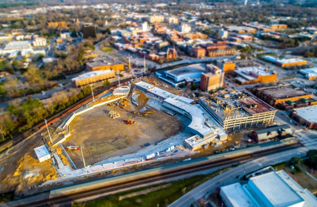
In 2019, I used the DJI Phantom 4 Pro to capture aerial shots of a baseball stadium being built, then crafted tilt-shift miniatures in Photoshop. Below are the photos I created along with information and tips to help you get out and create your own ‘miniature effect’ photos.
Capturing the Image with DJI Phantom 4 Pro
The DJI Phantom 4 Pro is an advanced drone equipped with a 1-inch 20MP camera capable of capturing high-quality images. Its gimbal stabilization ensures sharp photos, crucial for the tilt-shift effect. To capture images suitable for tilt-shift photography, follow these steps:
- Plan Your Shot: Tilt-shift works best from a high angle looking down at your subject. Scout your location, in this case, the construction of a baseball stadium in North Carolina, and plan to shoot during times when shadows are present to enhance the three-dimensional feel.
- Positioning the Drone: Position the drone between 100 to 300 feet above the ground to capture a broad view of the subject while maintaining sufficient detail.
- Camera Settings: Set the camera to manual mode to control the exposure settings, ensuring the entire scene is in focus. A smaller aperture (high f-number) helps achieve a greater depth of field.
- Capturing Multiple Images: Capture multiple images to have options during the post-processing phase. Different angles can offer unique perspectives for the tilt-shift effect.

Post-Processing in Adobe Photoshop
Once you have your images, the next step is to process them in Adobe Photoshop to create the tilt-shift miniature effect:
- Selection of Focus Area: Open your image in Photoshop. The first step is to select the area that will remain in focus. This is typically a horizontal strip across the image that simulates the shallow depth of field of a macro shot.
- Creating a Tilt-Shift Blur: Go to Filter > Blur Gallery > Tilt-Shift. Adjust the blur handles to set the area of the image that will be blurred, creating the illusion of a narrow depth of field.
- Adjusting the Blur: Fine-tune the amount of blur to enhance the miniature effect. Be careful not to overdo it; subtlety is key.
- Enhancing Colors and Contrast: Miniature models often have saturated colors and high contrast. Adjust the vibrancy and contrast sliders to mimic this look.
- Final Touches: Add sharpening to the focused area if necessary and consider cropping the image for the best composition.
Tips for Success
- The angle of the shot is crucial; the more top-down the angle, the more convincing the miniature effect will be.
- Morning or late afternoon when shadows are longer can add to the miniature effect, providing more depth and contrast.
- When applying the tilt-shift effect in Photoshop, make sure the transition between the in-focus and out-of-focus areas is smooth and gradual.
- Experiment with different levels of saturation and contrast to see what gives the most realistic ‘miniature’ look.
By combining the aerial capabilities of the drones available today and the powerful editing tools in Adobe Photoshop, photographers can create stunning, miniaturized representations of real-world scenes, such as a baseball stadium under construction. With practice, this technique can yield captivating images that offer a fresh perspective on everyday scenes.
Conclusion
The history of tilt-shift photography is a testament to the evolution of photographic techniques and the ingenuity of photographers in exploiting technological advances. Drone photographers continue to push the boundaries of this technique, using platforms like the Autel Robotics EVO series to capture the world in miniature and share a fresh perspective on our everyday environments.
 Paul Rossi, US Army Veteran, is the President at Nine Ten Drones, a N. C.-based drone services company, training center, and reseller. A graduate of Embry Riddle Aeronautical University (ERAU) and the U.S. Army Aviation Logistics School, Rossi is passionate about the aviation industry. He holds both a Private Pilot’s License w/ Instrument Rating for manned aircraft and a Part 107 Remote Pilot’s Certificate. Rossi is currently studying for his MS Space Operations from ERAU, energized to expand his reach beyond Earth’s atmosphere. You can see more videos and product information on the Nine Ten Drones YouTube channel and connect with Paul on LinkedIn.com

Miriam McNabb is the Editor-in-Chief of DRONELIFE and CEO of JobForDrones, a professional drone services marketplace, and a fascinated observer of the emerging drone industry and the regulatory environment for drones. Miriam has penned over 3,000 articles focused on the commercial drone space and is an international speaker and recognized figure in the industry. Miriam has a degree from the University of Chicago and over 20 years of experience in high tech sales and marketing for new technologies.
For drone industry consulting or writing, Email Miriam.
TWITTER:@spaldingbarker
Subscribe to DroneLife here.


Leave a Reply