• Skip to main content
  • Skip to secondary menu
  • Skip to primary sidebar
  • Skip to secondary sidebar
  • Skip to footer
  • DroneRacingLife
  • DroneFlyers
  • Newsletter
DroneLife

DRONELIFE

Stay up to date on all the latest Drone News

  • News
  • Products
  • Industries
    • Agriculture
    • Construction
    • Delivery
    • Dual Use
    • Inspection
    • Public Safety
    • Surveying
  • Enthusiasts
  • Regulations
  • Business
  • Video
  • Podcasts

Verizon and NOAA Team Up for Advanced Storm Damage Assessment

May 7, 2024 by Miriam McNabb 3 Comments

NOAA Verizon Drone PartnershipUtilizing Drone Technology, the New Collaboration Aims to Enhance Emergency Response and Mitigation Strategies During Hurricane Season

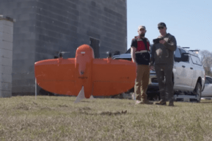
As hurricane season approaches, putting vital off-shore infrastructure at risk over the next few months, Verizon has announced a new partnership with the National Oceanic and Atmospheric Association to use uncrewed systems to rapidly survey storm damage immediately after major disasters. This three-year Cooperative Research and Development agreement is designed to integrate the personnel resources, flight equipment, and expertise of Verizon Frontline, Verizon’s in-house UAV division focused on infrastructure surveillance, with NOAA’s National Weather Service personnel. 

The goal of the project is to increase the data-collection capability of NOAA after major storms and tornadoes. This allows them to improve their damage assessment capability while also gaining additional information on tornado and storm behavior with a goal of improving warnings and mitigation techniques. 

“This collaboration has the potential to demonstrate how partnerships with Verizon and other organizations to gather drone imagery can significantly improve the services provided by the NWS to the public and partners when disaster strikes,” said Tim Oram, NWS Southern Region Headquarters Meteorological Services Branch Chief.

The CRADA applies to the Fort Worth, Texas-based NWS South region as well as NOAA’s National Severe Storms Laboratory. The deal will help protect the more than 77 million residents who live in the region, which is centered around the meteorologically active Gulf of Mexico and includes New Mexico, Texas, Oklahoma, Arkansas, Louisiana, Mississippi, Tennessee, Alabama, Georgia, and Florida, the Commonwealth of Puerto Rico and the U.S. Virgin Islands in the eastern Caribbean.

“This partnership will help pioneer new strategies aimed at gathering and disseminating crucial imagery, leveraging our collective expertise to enhance response efforts to severe storms and mitigate their impact on communities across the U.S.,” said Michael Adams, associate vice president for federal civilian services at Verizon.

Typically, after a storm, NOAA and the NWS deploy staff on the ground to survey storm damage, which can be dangerous and logistically difficult. Unmanned assets allow for more efficient information gathering, allowing for faster assignment of ratings and documentation of the storm’s path that researchers hope will improve future tornado and storm warnings. 

“After a crisis, the first imagery that any emergency management agency or similar public safety agency gets is typically satellite data and the resolution isn’t ideal,” said Chris Sanders of the Verizon Frontline Crisis Response Team. “What we’re aiming to do through our partnership with NOAA is develop ways to get these agencies high-resolution imagery much faster than they can get it today by using our robust network and rapid-mapping capabilities.”

More information on the NOAA/Verizon partnership is available here.

Miriam McNabb

Miriam McNabb is the Editor-in-Chief of DRONELIFE and CEO of JobForDrones, a professional drone services marketplace, and a fascinated observer of the emerging drone industry and the regulatory environment for drones. Miriam has penned over 3,000 articles focused on the commercial drone space and is an international speaker and recognized figure in the industry.  Miriam has a degree from the University of Chicago and over 20 years of experience in high tech sales and marketing for new technologies.
For drone industry consulting or writing, Email Miriam.

TWITTER:@spaldingbarker

Subscribe to DroneLife here.

Filed Under: Drone News, News Tagged With: advanced weather forecasting, drone storm damage assessment, emergency management technology, hurricane season response, NOAA storm research, NOAA Verizon partnership, rapid mapping capabilities, severe weather mitigation, UAV infrastructure surveillance, Verizon Frontline initiative

Reader Interactions

Trackbacks

  1. NOAA Verizon Drone Partnership – DRONELIFE – drone-app.com says:
    May 7, 2024 at 1:12 pm

    […] Supply hyperlink […]

    Reply
  2. Verizon and NOAA Team Up for Advanced Storm Damage Assessment – Wind-Tech FPV Drone Academy says:
    May 7, 2024 at 11:45 am

    […] post Verizon and NOAA Team Up for Advanced Storm Damage Assessment appeared first on […]

    Reply
  3. Verizon and NOAA Team Up for Advanced Storm Damage Assessment – Independent Drone Exchange says:
    May 7, 2024 at 11:03 am

    […] post Verizon and NOAA Team Up for Advanced Storm Damage Assessment appeared first on […]

    Reply

Leave a Reply Cancel reply

Your email address will not be published. Required fields are marked *

Primary Sidebar

LATEST

The Challenge of Drone Pizza Delivery: Flytrex Finally Solved It

Flytrex, Little Caesars join in first-of-kind pizza delivery By DRONELIFE Features Editor Jim Magill Over the past several years, residents…

Continue Reading The Challenge of Drone Pizza Delivery: Flytrex Finally Solved It

Headed to XPONENTIAL 2026? Don’t Miss These Partners, Panels, and Dual-Use Innovations in Detroit

From May 11-14, the annual AUVSI Xponential conference will bring the global autonomous systems industry to Detroit. This year’s conference…

Continue Reading Headed to XPONENTIAL 2026? Don’t Miss These Partners, Panels, and Dual-Use Innovations in Detroit

Rogue Cortex and UAS Nexus Launch Modular FPV Drone Developer Kit

Salt Lake City partnership pairs UAS Nexus’ Platform One airframe with Rogue Cortex’s SDK to give engineers a production-grade FPV…

Continue Reading Rogue Cortex and UAS Nexus Launch Modular FPV Drone Developer Kit

Titan Batteries Opens European Drone Battery Plant in Tilburg

The Idaho-based UAV power supplier becomes the first major drone battery maker to operate full-scale production on two continents. Titan…

Continue Reading Titan Batteries Opens European Drone Battery Plant in Tilburg

Detroit Trucking Hub Adds Birdstop Drone Monitoring with TSPS

Birdstop’s Fealty drone system delivers real-time truck parking visibility at the U.S.-Canada border in partnership with Detroit-based TSPS. Birdstop has…

Continue Reading Detroit Trucking Hub Adds Birdstop Drone Monitoring with TSPS

NASA Picks Pierce Aerospace for Bay Area Remote ID Sensor Network

Pierce Aerospace to Build Remote ID Network for NASA Across Silicon Valley and Bay Area Metis Technology Solutions taps the…

Continue Reading NASA Picks Pierce Aerospace for Bay Area Remote ID Sensor Network

Laminar-Flow Drone From Otto Aerospace Clears Flight-Test Campaign for DARPA

The Fort Worth aeronautics company validates its low-drag airframe at Spaceport America in support of DARPA’s Energy Web Aircraft program.…

Continue Reading Laminar-Flow Drone From Otto Aerospace Clears Flight-Test Campaign for DARPA

Military Selects First Bases for Directed-Energy Counter-Drone Program

Five military installations selected to support development of advanced drone defense systems The U.S. Department of Defense has announced the…

Continue Reading Military Selects First Bases for Directed-Energy Counter-Drone Program

AirData Joins Commercial Drone Alliance as Industry Prepares for Part 108

Company says its platform is built to support compliance and operational oversight for scaled BVLOS drone operations As the U.S.…

Continue Reading AirData Joins Commercial Drone Alliance as Industry Prepares for Part 108

UK Government Backs Drone Expansion with £50 Million Investment

Windracers among companies recognized as UK moves to scale routine drone operations and advanced air mobility The UK government has…

Continue Reading UK Government Backs Drone Expansion with £50 Million Investment

Secondary Sidebar

Footer

SPONSORED

Inspired Flight Gremsy IF800 VIO F1 drones geo week

What Will It Take to Strengthen U.S. Drone Manufacturing? A Conversation with Inspired Flight’s CEO

Global Mapper Mobile data collection

Collection Ground Control Points with Global Mapper Mobile

Military Drone Mapping Solutions

How SimActive’s Correlator3D™ is Revolutionizing Military Mapping: An Exclusive Interview with CEO Philippe Simard

Photogrammetry Accuracy Standards

SimActive Photogrammetry Software: Enabling Users to Meet Accuracy Standards for Over 20 Years

NACT Engineering Parrot ANAFI tether indoor shot

Smart Tether for Parrot ANAFI USA from NACT Engineering

Blue Marble, features global mapper, features Blue Marble

Check Out These New Features in Global Mapper v25 from Blue Marble

About Us | Contact Us | Advertise With Us | Write for Us | Privacy Policy | Terms of Service

The Trusted Source for the Business of Drones.

This website uses cookies and third party services. By clicking OK, you are agreeing to our privacy policy. ACCEPT

Manage consent

Privacy Overview

This website uses cookies to improve your experience while you navigate through the website. Out of these, the cookies that are categorized as necessary are stored on your browser as they are essential for the working of basic functionalities of the website. We also use third-party cookies that help us analyze and understand how you use this website. These cookies will be stored in your browser only with your consent. You also have the option to opt-out of these cookies. But opting out of some of these cookies may affect your browsing experience.
Necessary
Always Enabled
Necessary cookies are absolutely essential for the website to function properly. These cookies ensure basic functionalities and security features of the website, anonymously.
CookieDurationDescription
cookielawinfo-checkbox-analytics11 monthsThis cookie is set by GDPR Cookie Consent plugin. The cookie is used to store the user consent for the cookies in the category "Analytics".
cookielawinfo-checkbox-functional11 monthsThe cookie is set by GDPR cookie consent to record the user consent for the cookies in the category "Functional".
cookielawinfo-checkbox-necessary11 monthsThis cookie is set by GDPR Cookie Consent plugin. The cookies is used to store the user consent for the cookies in the category "Necessary".
cookielawinfo-checkbox-others11 monthsThis cookie is set by GDPR Cookie Consent plugin. The cookie is used to store the user consent for the cookies in the category "Other.
cookielawinfo-checkbox-performance11 monthsThis cookie is set by GDPR Cookie Consent plugin. The cookie is used to store the user consent for the cookies in the category "Performance".
viewed_cookie_policy11 monthsThe cookie is set by the GDPR Cookie Consent plugin and is used to store whether or not user has consented to the use of cookies. It does not store any personal data.
Functional
Functional cookies help to perform certain functionalities like sharing the content of the website on social media platforms, collect feedbacks, and other third-party features.
Performance
Performance cookies are used to understand and analyze the key performance indexes of the website which helps in delivering a better user experience for the visitors.
Analytics
Analytical cookies are used to understand how visitors interact with the website. These cookies help provide information on metrics the number of visitors, bounce rate, traffic source, etc.
Advertisement
Advertisement cookies are used to provide visitors with relevant ads and marketing campaigns. These cookies track visitors across websites and collect information to provide customized ads.
Others
Other uncategorized cookies are those that are being analyzed and have not been classified into a category as yet.
SAVE & ACCEPT