• Skip to main content
  • Skip to secondary menu
  • Skip to primary sidebar
  • Skip to secondary sidebar
  • Skip to footer
  • DroneRacingLife
  • DroneFlyers
  • Newsletter
DroneLife

DRONELIFE

Stay up to date on all the latest Drone News

  • News
  • Products
  • Industries
    • Agriculture
    • Construction
    • Delivery
    • Dual Use
    • Inspection
    • Public Safety
    • Surveying
  • Enthusiasts
  • Regulations
  • Business
  • Video
  • Podcasts

Innovative Drone Program Combats Global Landmine Crisis with AI Precision

December 15, 2023 by Miriam McNabb 7 Comments

Drone AI Landmine Detection

Safe Pro launches program to use drones, AI in landmine detection

By DRONELIFE Features Editor Jim Magill

Landmines, which kill or injure as many as 100,000 people in nations across the world every year, represent a global health crisis.

Experts at the organization behind the international Minesweepers estimate that currently there are 110 million land mines in the ground in about 60 countries. Locating and removing mines by traditional methods involving humans equipped with metal detectors and a big dose of courage, is dangerous, expensive and highly inefficient.

A start-up drone and artificial intelligence (AI) company, using off-the-shelf drones and machine learning algorithms is striving to rise to the challenge of introducing a technology-based solution to the worldwide landmine crisis.

“We’re eager to share the work that we’re doing and the results of what we’re doing and make a significant impact in the world,” Dan Erdberg, CEO of Safe Pro Group, said in an interview. Safe Pro’s subsidiary, Safe Pro AI, is currently conducting a drone-enabled demining pilot program in war-torn Ukraine.

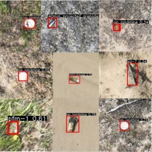
Using off-the-shelf small aerial vehicles and its propriety technology, SpotlightAi, initial results have proven to be promising, locating 60 or more mines in one of its initial field tests in the Ukrainian countryside, said Jasper Baur, Safe Pro AI’s co-founder and lead scientist.

 SpotlightAi harnesses machine-learning models to process massive amounts of sub-centimeter-level captured by commercially available drones. Powered by the Amazon Web Services cloud, the platform is able to instant processes drone-collected images, using “an extensive proprietary dataset of hundreds of thousands of labeled images of over 150 various types of landmines and unexploded ordnance,” according to a recent company press release.

The types of UXO that can be identified by the system range from small, anti-personnel devices known as butterfly mines – devices that when trigged can fly upwards and explode, killing or maiming any unfortunate farmer or child who happens to come into contact with them – to American-supplied unexploded cluster munitions.

The SpotlightAi technology instantly detects, labels and assigns a GPS tag to any surface mines and other explosive remnants of war and generates detailed reports that provide actionable intelligence to the appropriate government entities and non-governmental organizations engaged in demining operations.

Safe Pro officials made a presentation on the development of on SpotlightAi at a recent meeting of the Geneva International Centre for Humanitarian Demining. The prestigious group acknowledged that the technology represented a breakthrough in the dangerous and import business of detecting landmines, Baur said.

“Right now, no one’s using any kind of AI for analyzing their drone imagery,” he said. “The benefit of SpotlightAi is that it provides the analysis almost instantly,”

In order to develop the machine-learning model, Safe Pro AI’s team labeled more than 100,000 different items and made images showing the items from different viewpoints to teach the software how to distinguish a landmine or other piece of unexploded ordinance from other objects found in real-world environments. “It creates this general idea of what a grenade is, what a rock is, what an anti-tank mine is,” Baur said. With these models in its electronic mind, the software uploads imagery captured with a drone, applies that learned information to identify all potential hazards on a map.

The system is built for use with any commercial off-the-shelf aerial vehicles. The SpotlightAi team has employed the system with drones from a variety of providers, including DJI and Parrot. One of the chief benefits of the Spotlight Ai system is that it’s compatible with essentially any drone equipped with a visible-light camera with 12-megapixal or greater resolution, Erdberg said.

Ukraine

In war-torn Ukraine, Safe Pro teams have been working for the past several months with the nation’s Ministry of Defense and The HALO Trust, a non-governmental organization dedicated to international demining efforts, to prove the efficacy of the SpotlightAi system. The scope of the problem in that country is huge. Experts estimate that large sections of the country, equal in area to the state of Florida, are seeded with hidden unexploded ordinance, likely to pose a deadly danger for a long time, even after the hostilities eventually end.

Experts estimate that it could take up to 800 years to completely clear the country of unexploded ordinance using traditional methods.

“The World Bank has allocated over a billion and a half dollars for demining in Ukraine,” Erdberg said. “There’s a lot of activity right now going into how do we tackle this problem efficiently and effectively. And they’re looking at new technologies.”

Bauer, in his fourth year of a PhD program at Columbia University, has had a longtime interest in the nascent field of landmine detection as a future career path, although his primary field of doctoral research involves volcanos.

“I studied demining first,” he said. “And then, since my background was in geology, I went into graduate school in volcanology because there’s no program for landmine detection. It’s just very uncommon.”

As it turned out, the study of volcanos proved to be valuable in developing his anti-landmine system, as both mines and volcanos represent potential explosive hazards that endangered humans. “I developed a lot of skills that I used doing studying volcanology that I use every day for detecting mines and doing the mining work,” he said.

His early fundamental research proved the feasibility of using drones equipped with visual and thermal imagery detect equipment to detect foreign objects lying on the surface of the ground. The challenge then was how to scale up the drone-based mine-detection model into a system that could be duplicated on a large scale.

“How is this something that can really reach millions of people and be a useful skill set? That is where the machine learning comes in,” Baur said. With friend and colleague, Gabriel Steinberg, Baur cofounded Safe Pro AI to develop a machine learning model that can automate the detections of landmines and other unexploded ordinance.

Safe Pro Group

Safe Pro AI is one of three affiliated companies in the Safe Pro Group, the other two being SafeProUSA and Airborne Response. SafeProUSA builds body armor and equipment used in explosive ordnance disposal and mine-clearing. Airborne Response is a Florida-based drone services provider that provides critical mission services for customers who don’t want to assemble their own fleet of drones.

Erdberg said the three companies work in tandem to provide a complete end-to-end solution to the vital job of dealing with unexploded ordinance. “We can provide you the drone services, we can provide you the AI and ML, and then we can provide you the ballistic protection you need to eventually go and bring the human into the loop to clean the minefield,” he said.

Jim Magill is a Houston-based writer with almost a quarter-century of experience covering technical and economic developments in the oil and gas industry. After retiring in December 2019 as a senior editor with S&P Global Platts, Jim began writing about emerging technologies, such as artificial intelligence, robots and drones, and the ways in which they’re contributing to our society. In addition to DroneLife, Jim is a contributor to Forbes.com and his work has appeared in the Houston Chronicle, U.S. News & World Report, and Unmanned Systems, a publication of the Association for Unmanned Vehicle Systems International.

Read more:

  • Scientists Turn to Drones to Better Detect Deadly Landmines
  • AI-Powered Obstacle Detection for Tethered Drones: KEF Robotics Revolutionizes Military Surveillance
  • Revolutionizing Defense: Shield AI’s V-BAT Teams Enable Autonomous Surveillance in Hostile Environments
Miriam McNabb

Miriam McNabb is the Editor-in-Chief of DRONELIFE and CEO of JobForDrones, a professional drone services marketplace, and a fascinated observer of the emerging drone industry and the regulatory environment for drones. Miriam has penned over 3,000 articles focused on the commercial drone space and is an international speaker and recognized figure in the industry.  Miriam has a degree from the University of Chicago and over 20 years of experience in high tech sales and marketing for new technologies.
For drone industry consulting or writing, Email Miriam.

TWITTER:@spaldingbarker

Subscribe to DroneLife here.

Filed Under: Applications, Data analytics, Defense, DL Exclusive, Drone News, Drone News Feeds, Dual Use, Feature 1, News, Products, Selected – Safety and Security Tagged With: AI drones, drones for landmine detection, drones for war, drones in Ukraine, drones in war, Safe Pro

Reader Interactions

Comments

  1. Dr Rock says

    September 20, 2024 at 11:23 am

    So in summary. Safe pro will make $$$$$ by locating landmines but humans on the ground still have to defuse and detonate whilst safe pro guy sits in his office.. excellent.

    Reply

Trackbacks

  1. Innovative Drone Program Combats Global Landmine Crisis with AI Precision – Elevated Vision says:
    December 21, 2023 at 5:53 pm

    […] More… […]

    Reply
  2. Drone AI Landmine Detection Secure Professional Group - Hello says:
    December 17, 2023 at 6:09 pm

    […] Miriam McNabb is the Editor-in-Chief of DRONELIFE and CEO of JobForDrones, knowledgeable drone providers market, and a fascinated observer of the rising drone business and the regulatory surroundings for drones. Miriam has penned over 3,000 articles centered on the industrial drone area and is a world speaker and acknowledged determine within the business.  Miriam has a level from the College of Chicago and over 20 years of expertise in excessive tech gross sales and advertising for brand spanking new applied sciences.For drone business consulting or writing, E mail Miriam. […]

    Reply
  3. Innovative Drone Program Combats Global Landmine Crisis with AI Precision - Dronestag Blog says:
    December 17, 2023 at 11:45 am

    […] More… […]

    Reply
  4. Drone AI Landmine Detection Protected Professional Group - Enjbs says:
    December 15, 2023 at 7:00 pm

    […] Miriam McNabb is the Editor-in-Chief of DRONELIFE and CEO of JobForDrones, knowledgeable drone companies market, and a fascinated observer of the rising drone business and the regulatory atmosphere for drones. Miriam has penned over 3,000 articles centered on the industrial drone area and is a global speaker and acknowledged determine within the business.  Miriam has a level from the College of Chicago and over 20 years of expertise in excessive tech gross sales and advertising and marketing for brand new applied sciences.For drone business consulting or writing, E-mail Miriam. […]

    Reply
  5. Innovative Drone Program Combats Global Landmine Crisis with AI Precision - Worldnews4 says:
    December 15, 2023 at 4:51 pm

    […] Miriam McNabb is the Editor-in-Chief of DRONELIFE and CEO of JobForDrones, a professional drone services marketplace, and a fascinated observer of the emerging drone industry and the regulatory environment for drones. Miriam has penned over 3,000 articles focused on the commercial drone space and is an international speaker and recognized figure in the industry.  Miriam has a degree from the University of Chicago and over 20 years of experience in high tech sales and marketing for new technologies.For drone industry consulting or writing, Email Miriam. […]

    Reply
  6. Innovative Drone Program Combats Global Landmine Crisis with AI Precision – Independent Drone Exchange says:
    December 15, 2023 at 2:37 pm

    […] post Innovative Drone Program Combats Global Landmine Crisis with AI Precision appeared first on […]

    Reply

Leave a Reply Cancel reply

Your email address will not be published. Required fields are marked *

Primary Sidebar

LATEST

AeroDefense Launches No-Cost Drone Detection Access Program for Law Enforcement

AirWarden Essentials customers can now share drone detection data with SLTT, DHS, and FBI partners at no added cost AeroDefense…

Continue Reading AeroDefense Launches No-Cost Drone Detection Access Program for Law Enforcement

Versaterm Acquires Aloft to Expand Drone Capabilities for Public Safety

Deal adds FAA-approved airspace intelligence to DroneSense platform Versaterm has announced the acquisition of Aloft, an FAA-approved provider of airspace…

Continue Reading Versaterm Acquires Aloft to Expand Drone Capabilities for Public Safety

Trojan Horse or Trade Dispute? Texas Attorney General Targets Anzu in High-Stakes Drone Lawsuit

Texas AG sues Anzu, claims company sells DJI clones By DRONELIFE Features Editor Jim Magill Claiming that the company is…

Continue Reading Trojan Horse or Trade Dispute? Texas Attorney General Targets Anzu in High-Stakes Drone Lawsuit

Geo Week to Relocate to Salt Lake City in 2027

Leading Geospatial Event Moves to Utah’s Expanding Technology Hub Geo Week will relocate to Salt Lake City, Utah in 2027,…

Continue Reading Geo Week to Relocate to Salt Lake City in 2027

Eric Trump Invests in XTEND as Israeli Drone Firm Announces Plan to Go Public via Nasdaq Merger

AI-powered robotics company targets $1.5B valuation in U.S. listing Israeli drone and robotics company XTEND has announced plans to go…

Continue Reading Eric Trump Invests in XTEND as Israeli Drone Firm Announces Plan to Go Public via Nasdaq Merger

New Partnership Building Farming Drone Batteries in Texas

KULR Technology Group and Hylio have entered a joint collaboration to produce NDAA-compliant battery systems for agricultural drones built in…

Continue Reading New Partnership Building Farming Drone Batteries in Texas

FlytBase Unveils FlytBase One Management System

FlytBase has introduced FlytBase One, a unified control platform built to connect autonomous drones, robots, and physical infrastructure. The company also…

Continue Reading FlytBase Unveils FlytBase One Management System

Sentrycs Scout Expands Counter-Drone Capabilities for Law Enforcement

Sentrycs, an Ondas Inc. subsidiary specializing in counter-drone technology, has delivered its C-UAS solution to a German State Police department.…

Continue Reading Sentrycs Scout Expands Counter-Drone Capabilities for Law Enforcement

Training for the Threat: FBI Expands Counter-Drone Force Ahead of Historic World Cup

FBI on track to train 60 state, local officers in drone mitigation by June By DRONELIFE Features Editor Jim Magill…

Continue Reading Training for the Threat: FBI Expands Counter-Drone Force Ahead of Historic World Cup

Spexi Orthomosaic Drone Imagery Now Available on SkyWatch Platform

SkyWatch has announced the addition of Spexi orthomosaic drone imagery to its platform, expanding access to standardized aerial data for…

Continue Reading Spexi Orthomosaic Drone Imagery Now Available on SkyWatch Platform

Secondary Sidebar

Footer

SPONSORED

Inspired Flight Gremsy IF800 VIO F1 drones geo week

What Will It Take to Strengthen U.S. Drone Manufacturing? A Conversation with Inspired Flight’s CEO

Global Mapper Mobile data collection

Collection Ground Control Points with Global Mapper Mobile

Military Drone Mapping Solutions

How SimActive’s Correlator3D™ is Revolutionizing Military Mapping: An Exclusive Interview with CEO Philippe Simard

Photogrammetry Accuracy Standards

SimActive Photogrammetry Software: Enabling Users to Meet Accuracy Standards for Over 20 Years

NACT Engineering Parrot ANAFI tether indoor shot

Smart Tether for Parrot ANAFI USA from NACT Engineering

Blue Marble, features global mapper, features Blue Marble

Check Out These New Features in Global Mapper v25 from Blue Marble

About Us | Contact Us | Advertise With Us | Write for Us | Privacy Policy | Terms of Service

The Trusted Source for the Business of Drones.

This website uses cookies and third party services. By clicking OK, you are agreeing to our privacy policy. ACCEPT

Manage consent

Privacy Overview

This website uses cookies to improve your experience while you navigate through the website. Out of these, the cookies that are categorized as necessary are stored on your browser as they are essential for the working of basic functionalities of the website. We also use third-party cookies that help us analyze and understand how you use this website. These cookies will be stored in your browser only with your consent. You also have the option to opt-out of these cookies. But opting out of some of these cookies may affect your browsing experience.
Necessary
Always Enabled
Necessary cookies are absolutely essential for the website to function properly. These cookies ensure basic functionalities and security features of the website, anonymously.
CookieDurationDescription
cookielawinfo-checkbox-analytics11 monthsThis cookie is set by GDPR Cookie Consent plugin. The cookie is used to store the user consent for the cookies in the category "Analytics".
cookielawinfo-checkbox-functional11 monthsThe cookie is set by GDPR cookie consent to record the user consent for the cookies in the category "Functional".
cookielawinfo-checkbox-necessary11 monthsThis cookie is set by GDPR Cookie Consent plugin. The cookies is used to store the user consent for the cookies in the category "Necessary".
cookielawinfo-checkbox-others11 monthsThis cookie is set by GDPR Cookie Consent plugin. The cookie is used to store the user consent for the cookies in the category "Other.
cookielawinfo-checkbox-performance11 monthsThis cookie is set by GDPR Cookie Consent plugin. The cookie is used to store the user consent for the cookies in the category "Performance".
viewed_cookie_policy11 monthsThe cookie is set by the GDPR Cookie Consent plugin and is used to store whether or not user has consented to the use of cookies. It does not store any personal data.
Functional
Functional cookies help to perform certain functionalities like sharing the content of the website on social media platforms, collect feedbacks, and other third-party features.
Performance
Performance cookies are used to understand and analyze the key performance indexes of the website which helps in delivering a better user experience for the visitors.
Analytics
Analytical cookies are used to understand how visitors interact with the website. These cookies help provide information on metrics the number of visitors, bounce rate, traffic source, etc.
Advertisement
Advertisement cookies are used to provide visitors with relevant ads and marketing campaigns. These cookies track visitors across websites and collect information to provide customized ads.
Others
Other uncategorized cookies are those that are being analyzed and have not been classified into a category as yet.
SAVE & ACCEPT