• Skip to main content
  • Skip to secondary menu
  • Skip to primary sidebar
  • Skip to secondary sidebar
  • Skip to footer
  • DroneRacingLife
  • DroneFlyers
  • Newsletter
DroneLife

DRONELIFE

Stay up to date on all the latest Drone News

  • News
  • Products
  • Industries
    • Agriculture
    • Construction
    • Delivery
    • Dual Use
    • Inspection
    • Public Safety
    • Surveying
  • Enthusiasts
  • Regulations
  • Business
  • Video
  • Podcasts

Mapping Paradise: Event 38 and PLACE Partner to Map Turks and Caicos

April 10, 2023 by Miriam McNabb 6 Comments

Event 38 mapping Turks and CaicosEvent 38 and PLACE Partner to Map Turks and Caicos Islands Using E400 Drones

by DRONELIFE Staff Writer Ian M. Crosby

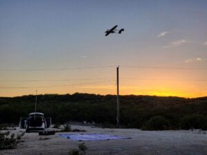
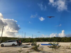
Mapping drone manufacturer Event 38 Unmanned Systems has announced the successful deployment of its E400 fixed-wing mapping drone for the collection of aerial imagery and mapping data in Turks and Caicos, which had not been mapped in at least ten years. In only a number of days, the drone gathered sufficient data to produce orthomosaics of the entirety of both islands, totaling 238 square kilometers. The project was conducted by PLACE, a global non-profit organization granting access to mapping data by providing hyperlocal and precise optical imagery.

“It can be difficult and expensive to get an airplane into the geographies where we work. Satellite imagery is quite complicated to order and process the data, and many of these geographies have intense cloud cover, which can disturb the imagery,” said PLACE founder Peter Rabley. “Some countries dislike the fact that they have to pay an external satellite company for one-time use of their mapping data and can’t create derived works without paying more for a new license.”

“PLACE was looking for a fixed-wing, VTOL drone with a long flight time that could map large areas and capture high-resolution imagery,” said Event 38 founder and CEO Jeff Taylor. “The E400 fulfilled all of their requirements, including an industry-leading flight time of ninety minutes, plus vertical takeoff and landing capabilities. We were also intentional about making the E400 as user-friendly as possible, including a hot-swap payload, a low maintenance electric powertrain, and open-source integrations, so we could remove any barriers to entry that might prevent someone from using it for important surveying and data collection projects.”

“The E400 is a complete game changer in terms of democratizing mapping for African countries and small island states,” said Rabley. “It’s very manageable in terms of operations and maintenance and has a lower threshold for human resource capabilities.”

PLACE conducted its first mapping project utilizing the E400  in Turks and Caicos, a Caribbean archipelagic island nation. The islands’ outdated mapping data and existing satellite data was insufficient for local applications such as hurricane preparedness and mitigation. The Event 38 team provided PLACE with training in the use and maintenance of the drone, which was used to map the entirety of the two islands.

Event 38 mappingIn only two days after the team finished gathering aerial imagery, they were able to produce highly detailed orthomosaics. With the E400, the Turks and Caicos government received access to data with sufficient accuracy and resolution to initiate several crucial projects, such as a major upgrade to their property tax system and improved climate mitigation modeling and planning. This data is currently being leveraged for the upcoming Census and other important activities.

Its mission leveraging the E400 in Turks and Caicos is the first of many for PLACE, which has already purchased two additional models. Access to updated mapping data is essential for locations with rapidly-increasing populations and cities, especially for those at risk from climate change. Current and accurate data enables governments to move forward with the development of public services and structures, including climate mitigation, upgraded sewer systems, improved mobility, and health services.

“Based on what we learned during our time in Turks and Caicos with PLACE, we’re making a lot of exciting modifications to both the E400 and the workflow to make the entire platform better suited to remote locations, where there may be limited cell service, repair facilities, and accessible weather data,” said Taylor. “We’ve already invested in a lighter carrying case and an ADS-B transponder and improved the image geotagging workflow for large missions, and further upgrades are in the works.”

“At PLACE, our goal is to democratize and localize data collection, and the E400 makes that much more affordable,” said Rabley. “The data is immediate and owned by the government, so there are no licensing or use restrictions.”

“Event 38 is incredibly proud to be supporting PLACE’s important work and mission,” added Taylor. “We look forward to seeing what our other clients do with the E400.”

Read more:

  • Event 38 Adds NextVision EO/IR Payload to E400 Fixed Wing Mapping Drone
  • Event 38 Fuel Cell Powered Fixed Wing Drone: Extended Flight Time, Reduced Noise
  • Event 38 E400 Fixed Wing Mapping Drone, Made in the U.S.
  • Event 38 and UmapAV Deliver Drone Based Hi-Value Analytics

Ian attended Dominican University of California, where he received a BA in English in 2019. With a lifelong passion for writing and storytelling and a keen interest in technology, he is now contributing to DroneLife as a staff writer.


Miriam McNabb

Miriam McNabb is the Editor-in-Chief of DRONELIFE and CEO of JobForDrones, a professional drone services marketplace, and a fascinated observer of the emerging drone industry and the regulatory environment for drones. Miriam has penned over 3,000 articles focused on the commercial drone space and is an international speaker and recognized figure in the industry.  Miriam has a degree from the University of Chicago and over 20 years of experience in high tech sales and marketing for new technologies.
For drone industry consulting or writing, Email Miriam.

TWITTER:@spaldingbarker

Subscribe to DroneLife here.

Filed Under: Drone News, Drone News Feeds, Featured - Surveying, News, Survey, Surveying

Reader Interactions

Trackbacks

  1. Drone News of the Week, April 14: DRONELIFE Headlines, All in One Place to Read or Listen - SkyDance Imaging says:
    April 14, 2023 at 3:05 pm

    […] Mapping Paradise: Event 38 and PLACE Partner to Map Turks and Caicos […]

    Reply
  2. PLACE, Event 38 mapping Turks and Caicos says:
    April 11, 2023 at 1:35 am

    […] More… […]

    Reply
  3. PLACE, Event 38 mapping Turks and Caicos - Fantastin says:
    April 10, 2023 at 6:44 pm

    […] Source link […]

    Reply
  4. PLACE, Event 38 mapping Turks and Caicos – Game Up News says:
    April 10, 2023 at 3:40 pm

    […] Source link […]

    Reply
  5. Mapping Paradise: Event 38 and PLACE Partner to Map Turks and Caicos - April 10, 2023 at 02:44PM - John Jason Fallows says:
    April 10, 2023 at 2:45 pm

    […] post Mapping Paradise: Event 38 and PLACE Partner to Map Turks and Caicos appeared first on […]

    Reply
  6. Mapping Paradise: Event 38 and PLACE Partner to Map Turks and Caicos - UAV FL says:
    April 10, 2023 at 2:19 pm

    […] post Mapping Paradise: Event 38 and PLACE Partner to Map Turks and Caicos appeared first on […]

    Reply

Leave a Reply Cancel reply

Your email address will not be published. Required fields are marked *

Primary Sidebar

LATEST

Vector, SR2 to Localize Attritable Drone Systems in Saudi Arabia

Vector and Saudi Arabia’s SR2 Defense Systems have signed a Memorandum of Understanding (MoU) to localize production of attritable drone…

Continue Reading Vector, SR2 to Localize Attritable Drone Systems in Saudi Arabia

Apellix Names Drone Clean UK as Exclusive Cleaning Drone Distributor

Apellix has named Drone Clean UK as the exclusive distributor for its autonomous cleaning drones in the United Kingdom. The…

Continue Reading Apellix Names Drone Clean UK as Exclusive Cleaning Drone Distributor

DOT and FAA Launch eVTOL Integration Pilot Program

By Dronelife Features Editor Jim Magill Although the future of jet-propelled cars whizzing across the sky, as portrayed in The…

Continue Reading DOT and FAA Launch eVTOL Integration Pilot Program

FDNY Explores Convergence of Robotics for Public Safety Operations

At DRONERESPONDERS conference, FDNY’s Mike Leo discusses integrating drones, ground robots, and other robotic systems to improve situational awareness Public…

Continue Reading FDNY Explores Convergence of Robotics for Public Safety Operations

Counter-Drone Systems Are Moving From Experiments to Real Infrastructure

New deployments, interceptor drones, and layered defense strategies show how counter-UAS technology is evolving into a structured global security architecture.…

Continue Reading Counter-Drone Systems Are Moving From Experiments to Real Infrastructure

Hydrogen-powered Z1 UAS Enters U.S. Army Acquisition Pipeline

Heven AeroTech has secured a Basic Ordering Agreement (BOA) with the U.S. Army Contracting Command – Redstone Arsenal for its…

Continue Reading Hydrogen-powered Z1 UAS Enters U.S. Army Acquisition Pipeline

Dublin Hospitals Test High-Speed Drone Delivery With Manna

A new simulation in Dublin highlights how medical drone delivery could reshape inter-hospital transport of critical supplies in Ireland. Rotunda Hospital led…

Continue Reading Dublin Hospitals Test High-Speed Drone Delivery With Manna

Hungary’s ABZ Innovation Challenges Farm Drone Giants

A Hungarian drone start-up is seeking to challenge the market-leading China-based manufacturers that dominate international markets for heavy-duty drones used…

Continue Reading Hungary’s ABZ Innovation Challenges Farm Drone Giants

NASA Explores Airspace Prioritization for Public Safety Drone Operations

New testing examines how emergency responders can maintain priority access to airspace as commercial drone traffic grows As drone operations…

Continue Reading NASA Explores Airspace Prioritization for Public Safety Drone Operations

Why the ADS-B Fee Debate Matters for the Future of Drones and Shared Airspace

As lawmakers move to limit the use of ADS-B data for fee collection, the debate highlights broader issues around surveillance…

Continue Reading Why the ADS-B Fee Debate Matters for the Future of Drones and Shared Airspace

Secondary Sidebar

Footer

SPONSORED

Inspired Flight Gremsy IF800 VIO F1 drones geo week

What Will It Take to Strengthen U.S. Drone Manufacturing? A Conversation with Inspired Flight’s CEO

Global Mapper Mobile data collection

Collection Ground Control Points with Global Mapper Mobile

Military Drone Mapping Solutions

How SimActive’s Correlator3D™ is Revolutionizing Military Mapping: An Exclusive Interview with CEO Philippe Simard

Photogrammetry Accuracy Standards

SimActive Photogrammetry Software: Enabling Users to Meet Accuracy Standards for Over 20 Years

NACT Engineering Parrot ANAFI tether indoor shot

Smart Tether for Parrot ANAFI USA from NACT Engineering

Blue Marble, features global mapper, features Blue Marble

Check Out These New Features in Global Mapper v25 from Blue Marble

About Us | Contact Us | Advertise With Us | Write for Us | Privacy Policy | Terms of Service

The Trusted Source for the Business of Drones.

This website uses cookies and third party services. By clicking OK, you are agreeing to our privacy policy. ACCEPT

Manage consent

Privacy Overview

This website uses cookies to improve your experience while you navigate through the website. Out of these, the cookies that are categorized as necessary are stored on your browser as they are essential for the working of basic functionalities of the website. We also use third-party cookies that help us analyze and understand how you use this website. These cookies will be stored in your browser only with your consent. You also have the option to opt-out of these cookies. But opting out of some of these cookies may affect your browsing experience.
Necessary
Always Enabled
Necessary cookies are absolutely essential for the website to function properly. These cookies ensure basic functionalities and security features of the website, anonymously.
CookieDurationDescription
cookielawinfo-checkbox-analytics11 monthsThis cookie is set by GDPR Cookie Consent plugin. The cookie is used to store the user consent for the cookies in the category "Analytics".
cookielawinfo-checkbox-functional11 monthsThe cookie is set by GDPR cookie consent to record the user consent for the cookies in the category "Functional".
cookielawinfo-checkbox-necessary11 monthsThis cookie is set by GDPR Cookie Consent plugin. The cookies is used to store the user consent for the cookies in the category "Necessary".
cookielawinfo-checkbox-others11 monthsThis cookie is set by GDPR Cookie Consent plugin. The cookie is used to store the user consent for the cookies in the category "Other.
cookielawinfo-checkbox-performance11 monthsThis cookie is set by GDPR Cookie Consent plugin. The cookie is used to store the user consent for the cookies in the category "Performance".
viewed_cookie_policy11 monthsThe cookie is set by the GDPR Cookie Consent plugin and is used to store whether or not user has consented to the use of cookies. It does not store any personal data.
Functional
Functional cookies help to perform certain functionalities like sharing the content of the website on social media platforms, collect feedbacks, and other third-party features.
Performance
Performance cookies are used to understand and analyze the key performance indexes of the website which helps in delivering a better user experience for the visitors.
Analytics
Analytical cookies are used to understand how visitors interact with the website. These cookies help provide information on metrics the number of visitors, bounce rate, traffic source, etc.
Advertisement
Advertisement cookies are used to provide visitors with relevant ads and marketing campaigns. These cookies track visitors across websites and collect information to provide customized ads.
Others
Other uncategorized cookies are those that are being analyzed and have not been classified into a category as yet.
SAVE & ACCEPT