
Funding led by NATO Innovation Fund supports growth in defense, AI, and dual-use applications Kelluu, a Finnish deep tech company, has raised €15 million in Series A funding to expand its autonomous airship platform and scale international operations. The round was led by the NATO Innovation Fund, marking its first investment in a Finnish company. The funding will support … [Read more...] about Bridging the Gap: Kelluu’s Airships Sit Between Drones and Satellites
Survey
Rapid Mapping for a 24/7 Defense Environment: SimActive on Speed, Security, and Scalable Intelligence

As defense budgets rise and geopolitical tensions reshape operational priorities, militaries are investing heavily in technologies that can turn raw data into timely, actionable intelligence. For photogrammetry company SimActive, that mission has been central since its founding. In a recent interview with DRONELIFE, CEO Dr. Philippe Simard discussed how the … [Read more...] about Rapid Mapping for a 24/7 Defense Environment: SimActive on Speed, Security, and Scalable Intelligence
Spexi Orthomosaic Drone Imagery Now Available on SkyWatch Platform

SkyWatch has announced the addition of Spexi orthomosaic drone imagery to its platform, expanding access to standardized aerial data for mapping and analysis. The integration allows users to source ultra-high-resolution drone imagery directly through SkyWatch’s EXPLORE and HUB applications. With the launch, SkyWatch customers can access Spexi’s stitched, orthorectified imagery … [Read more...] about Spexi Orthomosaic Drone Imagery Now Available on SkyWatch Platform
Phase One Unveils iXM-FS130 Camera for Sub-Centimeter Aerial Mapping
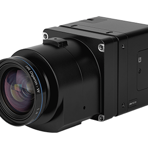
Phase One has announced the iXM-FS130, a next-generation aerial mapping camera designed to capture sub-centimeter ground sample distance imagery from fixed-wing aircraft at speeds exceeding 120 knots. The camera introduces Phase One's patented Fusion Shutter technology to the commercial aerial mapping market. This enables operators to maintain image quality while increasing … [Read more...] about Phase One Unveils iXM-FS130 Camera for Sub-Centimeter Aerial Mapping
From Intergeo 2025: Digital Twin Technology Preserves Alcatraz Island

A groundbreaking digital preservation project has created the most comprehensive 3D map of Alcatraz Island ever produced, combining cutting-edge drone technology, artificial intelligence, and reality capture systems to document one of America's most notorious historical sites. Pete Kelsey, founder of VCTO Labs, presented the remarkable achievements of this ambitious project at … [Read more...] about From Intergeo 2025: Digital Twin Technology Preserves Alcatraz Island


