• Skip to main content
  • Skip to secondary menu
  • Skip to primary sidebar
  • Skip to secondary sidebar
  • Skip to footer
  • DroneRacingLife
  • DroneFlyers
  • Newsletter
DroneLife

DRONELIFE

Stay up to date on all the latest Drone News

  • News
  • Products
  • Industries
    • Agriculture
    • Construction
    • Delivery
    • Dual Use
    • Inspection
    • Public Safety
    • Surveying
  • Enthusiasts
  • Regulations
  • Business
  • Video
  • Podcasts

These Companies Use Military and Aviation Radar to Scale Urban Drone Operations in Calgary

September 20, 2022 by Miriam McNabb 3 Comments

urban drone operationsIN-FLIGHT Data and DeTect Inc. Partner for Canada’s First Scaled Urban Drone Operation

by DRONELIFE Staff Writer Ian M. Crosby

Advanced drone operator IN-FLIGHT Data, alongside advanced radar and remote sensing technologies leader DeTect Inc., completed a demonstration showcasing the importance of advanced radar when operating drones beyond visual line of sight (BVLOS) and within populated areas.

Continue reading below, or listen:

DroneLife · These – Companies – Use – Advanced – Radar – Systems – For – Urban – Drone – Operations

This accomplishment has made IN-FLIGHT Data the first ever drone operator in North America to carry out an urban cellular and radio network mapping project of this scale.

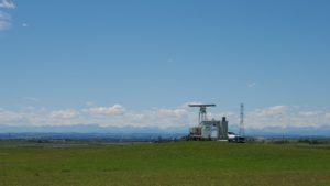
An advanced radar and remote sensing technologies specialist, DeTect develops solutions for the protection of airspace surrounding various critical sites from airborne hazards. Radar provides a means of granting drone operators airspace awareness surrounding other airspace users, with DeTect’s technology seeing deployment in a range of use cases including BVLOS flights.

As a result of concerns surrounding drone operation in areas close to sensitive bird populations, radar was utilized to grant additional safety, awareness and surveillance of all airspace users within the project’s vicinity, including birds. This same radar is currently employed elsewhere in Canada.

“Flying in urban environments, when the aircraft is beyond the line of sight of the pilot, is stressful and requires the pilot and crew’s full attention and awareness,” said IN-FLIGHT Data President Chris Healy. “The air band was busy with ATC communications. The airspace was busy with air space users of many types. It cannot be overstated how valuable the fused Unmanned Traffic Management (UTM) system and radar tools, including hardware and software, used by the project were – not only to the safety of the mission, but also for helping ease the stress burden on our air crew of a busy metro air space.”

The integrated solution offered roughly 15 NM / 28 km of airspace surveillance and remote reporting surrounding the project and throughout the City of Calgary. The mission area’s viewshed at all heights (>150 feet AGL) was ideal in every direction, with the entire airspace under surveillance within 3 NM of the missions. Surveillance coverage remained at over 90% in all directions at out to 5 NM. Flight missions conducted In July and August covered an operational area of about 22,000 acres within the City.

Canada GM James MacFarlane emphasized the importance of demonstrating the technology’s ability to cover a city of this size: “Projects such as the Calgary Project demonstrate that in order for cities to enable and scale the future of urban air mobility (UAM), they must first enable and promote networks, like airspace awareness, that qualified air operators can benefit from, while keeping operational costs low.”

A thorough understanding of the network performance is necessary in supporting further developments in aviation, as well as in evaluating how UAM, drones and infrastructure can leverage those networks for the benefit of cities and their citizens.

Read more about IN-FLIGHT and DeTect:

  • Its a Bird – Its a Drone -DeTect Dual Function Radar Tracks Both
  • In Calgary, a SAIL 4 BVLOS Urban Drone Operation Measures Aerial Network Performance

Ian attended Dominican University of California, where he received a BA in English in 2019. With a lifelong passion for writing and storytelling and a keen interest in technology, he is now contributing to DroneLife as a staff writer.


Miriam McNabb

Miriam McNabb is the Editor-in-Chief of DRONELIFE and CEO of JobForDrones, a professional drone services marketplace, and a fascinated observer of the emerging drone industry and the regulatory environment for drones. Miriam has penned over 3,000 articles focused on the commercial drone space and is an international speaker and recognized figure in the industry.  Miriam has a degree from the University of Chicago and over 20 years of experience in high tech sales and marketing for new technologies.
For drone industry consulting or writing, Email Miriam.

TWITTER:@spaldingbarker

Subscribe to DroneLife here.

Filed Under: Drone News, Drone News Feeds, News Tagged With: DeTect, in-flight data, IN-FLIGHT drone, radar for drones, urban drone operations

Reader Interactions

Trackbacks

  1. These Companies Use Military and Aviation Radar to Scale Urban Drone Operations in Calgary - Shadownews says:
    September 21, 2022 at 5:21 pm

    […] DeTect and IN-FLIGHT Data demonstrated the use of advanced radar systems to enable safe BVLOS and urban drone operations. Source […]

    Reply
  2. Advanced Radar for Urban Drone Operations says:
    September 21, 2022 at 8:18 am

    […] More… […]

    Reply
  3. These Companies Use Military and Aviation Radar to Scale Urban Drone Operations in Calgary - DroneLife - K드론팀 says:
    September 20, 2022 at 4:07 pm

    […] These Companies Use Military and Aviation Radar to Scale Urban Drone Operations in Calgary  DroneLife […]

    Reply

Leave a Reply Cancel reply

Your email address will not be published. Required fields are marked *

Primary Sidebar

LATEST

5 Federal Drone Policies Flying Under the Radar This Summer

From World Cup airspace restrictions to critical infrastructure rulemaking, several federal initiatives could shape the drone industry in the months…

Continue Reading 5 Federal Drone Policies Flying Under the Radar This Summer

Drone Industry Insights Launches the 9th Edition of the Global Drone Survey — The World’s Largest Annual Industry Survey for the Drone Market

Survey open to all actors in the global drone market ecosystem — manufacturers, operators, investors, associations, regulators, and service providers…

Continue Reading Drone Industry Insights Launches the 9th Edition of the Global Drone Survey — The World’s Largest Annual Industry Survey for the Drone Market

Proposed Patent Bill Could Have Major Implications for Drone Industry Intellectual Property

Prohibiting Adversarial Patents Act would make certain patents unenforceable while leaving ownership intact A newly introduced bill in Congress concerning…

Continue Reading Proposed Patent Bill Could Have Major Implications for Drone Industry Intellectual Property

Seattle Stadium “No-Drone Zone” During FIFA Matches

By Dronelife Features Editor Jim Magill Federal officials on Monday urged drone operators to stay away from Lumen Field, which…

Continue Reading Seattle Stadium “No-Drone Zone” During FIFA Matches

Landair Surveys Uses SimActive Correlator3D for Planned Burns Mapping in Australia

The Australian geospatial firm is using Correlator3D to generate orthomosaics from aerial imagery captured for wildfire prevention and land management…

Continue Reading Landair Surveys Uses SimActive Correlator3D for Planned Burns Mapping in Australia

As Disaster Risks Grow, WingXpand and Verizon Explore New Tools for Emergency Response

WingXpand will work with Verizon Frontline and emergency teams to explore new tools for disaster assessment and community resilience As…

Continue Reading As Disaster Risks Grow, WingXpand and Verizon Explore New Tools for Emergency Response

HOVERAir’s UK Launch Raises a Bigger Question: Who Will Serve America’s Consumer Drone Market?

HOVERAir has announced the UK launch of its new X1 Smart, a 99-gram self-flying camera designed to make aerial content…

Continue Reading HOVERAir’s UK Launch Raises a Bigger Question: Who Will Serve America’s Consumer Drone Market?

DRONELIFE Exclusive Interview: Inside PDW’s Strategy to Build Drones That Can Operate When GPS and Communications Fail

PDW works to develop advanced drone communications systems By DRONELIFE Features Editor Jim Magill As modern warfare increasingly relies on…

Continue Reading DRONELIFE Exclusive Interview: Inside PDW’s Strategy to Build Drones That Can Operate When GPS and Communications Fail

AirData UAV and LeoSight Bring Live Drone Data for DFR Programs

The new LeoSight AirData integration streams real-time flight data, telemetry, and operational insights from AirData directly into LeoCommand, giving dispatchers…

Continue Reading AirData UAV and LeoSight Bring Live Drone Data for DFR Programs

New Boson SX8 Brings High-Resolution Thermal Imaging to NDAA-Compliant Drone Payloads

New thermal imaging module combines SXGA resolution with compact size and U.S. manufacturing Teledyne FLIR OEM has announced the Boson…

Continue Reading New Boson SX8 Brings High-Resolution Thermal Imaging to NDAA-Compliant Drone Payloads

Secondary Sidebar

Footer

SPONSORED

Inspired Flight Gremsy IF800 VIO F1 drones geo week

What Will It Take to Strengthen U.S. Drone Manufacturing? A Conversation with Inspired Flight’s CEO

Global Mapper Mobile data collection

Collection Ground Control Points with Global Mapper Mobile

Military Drone Mapping Solutions

How SimActive’s Correlator3D™ is Revolutionizing Military Mapping: An Exclusive Interview with CEO Philippe Simard

Photogrammetry Accuracy Standards

SimActive Photogrammetry Software: Enabling Users to Meet Accuracy Standards for Over 20 Years

NACT Engineering Parrot ANAFI tether indoor shot

Smart Tether for Parrot ANAFI USA from NACT Engineering

Blue Marble, features global mapper, features Blue Marble

Check Out These New Features in Global Mapper v25 from Blue Marble

About Us | Contact Us | Advertise With Us | Write for Us | Privacy Policy | Terms of Service

The Trusted Source for the Business of Drones.

This website uses cookies and third party services. By clicking OK, you are agreeing to our privacy policy. ACCEPT

Manage consent

Privacy Overview

This website uses cookies to improve your experience while you navigate through the website. Out of these, the cookies that are categorized as necessary are stored on your browser as they are essential for the working of basic functionalities of the website. We also use third-party cookies that help us analyze and understand how you use this website. These cookies will be stored in your browser only with your consent. You also have the option to opt-out of these cookies. But opting out of some of these cookies may affect your browsing experience.
Necessary
Always Enabled
Necessary cookies are absolutely essential for the website to function properly. These cookies ensure basic functionalities and security features of the website, anonymously.
CookieDurationDescription
cookielawinfo-checkbox-analytics11 monthsThis cookie is set by GDPR Cookie Consent plugin. The cookie is used to store the user consent for the cookies in the category "Analytics".
cookielawinfo-checkbox-functional11 monthsThe cookie is set by GDPR cookie consent to record the user consent for the cookies in the category "Functional".
cookielawinfo-checkbox-necessary11 monthsThis cookie is set by GDPR Cookie Consent plugin. The cookies is used to store the user consent for the cookies in the category "Necessary".
cookielawinfo-checkbox-others11 monthsThis cookie is set by GDPR Cookie Consent plugin. The cookie is used to store the user consent for the cookies in the category "Other.
cookielawinfo-checkbox-performance11 monthsThis cookie is set by GDPR Cookie Consent plugin. The cookie is used to store the user consent for the cookies in the category "Performance".
viewed_cookie_policy11 monthsThe cookie is set by the GDPR Cookie Consent plugin and is used to store whether or not user has consented to the use of cookies. It does not store any personal data.
Functional
Functional cookies help to perform certain functionalities like sharing the content of the website on social media platforms, collect feedbacks, and other third-party features.
Performance
Performance cookies are used to understand and analyze the key performance indexes of the website which helps in delivering a better user experience for the visitors.
Analytics
Analytical cookies are used to understand how visitors interact with the website. These cookies help provide information on metrics the number of visitors, bounce rate, traffic source, etc.
Advertisement
Advertisement cookies are used to provide visitors with relevant ads and marketing campaigns. These cookies track visitors across websites and collect information to provide customized ads.
Others
Other uncategorized cookies are those that are being analyzed and have not been classified into a category as yet.
SAVE & ACCEPT