• Skip to main content
  • Skip to secondary menu
  • Skip to primary sidebar
  • Skip to secondary sidebar
  • Skip to footer
  • DroneRacingLife
  • DroneFlyers
  • Newsletter
DroneLife

DRONELIFE

Stay up to date on all the latest Drone News

  • News
  • Products
  • Industries
    • Agriculture
    • Construction
    • Delivery
    • Dual Use
    • Inspection
    • Public Safety
    • Surveying
  • Enthusiasts
  • Regulations
  • Business
  • Video
  • Podcasts

DroneDeploy’s New Products Go Far Beyond Drones

November 4, 2021 by Miriam McNabb 13 Comments

DroneDeploy's new productsDroneDeploy’s New Products: company launches mapping, inspection and ground-based robot products

By Jim Magill

Drone software company DroneDeploy unveiled a suite of new products, allowing customers to virtually walk through construction sites, capture and process data across miles of pipelines or electric transmission lines, and control walking inspection robots from across continents.

At its virtual DroneDeploy Conference 21, held in October, the company released the following products: its Walkthrough for iOS App and Floor Plan view, to improve the inspection capabilities at construction and industrial sites; Corridor Flight, which facilitates the creation of highly detailed maps roadways, railways, canals, pipelines or other linear areas; and a beta version of its Ground Robotics capability, which allows users to send quadrupeds, such as Boston Dynamics’ dog-like robot Spot, on autonomous inspection missions.

In addition, the company introduced new precise 3D measurement and photo-inspection tools and an improved view-only link-sharing capability for its inspection software, allowing users to call up visual inspection data on a project for a specific date, or for the entire project.

James Pipe, vice president of product, said DroneDeploy’s new products help further the company’s mission of transforming how businesses collect, manage and interpret drone data.

“Last year customers on our platform did 1.5 million flights. Many of those flights get uploaded as mapping missions, but people are capturing all kinds of data: photos, videos, 360-degree panoramas and inspections,” he said.

DroneDeploy's new products
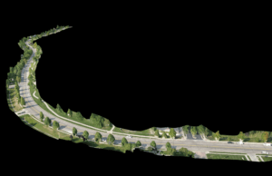
Although the Corridor Flight software was designed as a tool for mapping and analysis across great lineal distances – tracing roadway, railway, and oil and gas pipeline rights of way and conducting vegetation encroachment analysis – it can also provide detailed data for infrastructure inspections, such as finding a hot spot on an individual high voltage transmission tower.

Corridor Flight allows the user to create a corridor flight plan on a desktop computer or mobile device. As the drone begins its flight, the software package it carries will automatically track the terrain and check the airspace availability along the designated flight path.

“Then you set the width you want to capture, 100 feet, 200 feet or 300 feet of right-of-way that you need to be visible inside of the capture, Pipe said.

DroneDeploy released the software in a beta version several months ago and one customer already has mapped over 1,500 miles of roads and bridges, he said.

Walkthrough for IOS

The Walkthrough app that DroneDeploy released allows users to conduct site tours in 360-degree mode. “It starts with a mobile app you install on your iPhone. You have a 360 camera and you connect that to your phone and you walk around the site and create this beautiful path that goes through your construction site,” Pipe said.

The company also offers Floor Plan View for construction sites. This software can be used after the walls go up on a construction site and allows project managers to do reality captures of the indoor space. The data can be directly overlaid on floor plans and organized by level so that viewers can get a 3D representation of the entire building project.

“You can just jump in the floor plan and start viewing it,” Pipe said. This view is particularly useful for subcontractors as it allows them to assess the stage of readiness that a building project is in before they arrive on the job site.

“Tradespeople want to know the situation on the ground before they show up with a bunch of materials,” he said. He added that the software provides a multi-view perspective on a construction site, eliminating the need for interested parties to have to travel great distances to do an in-person inspection. “You can jump into the site from 3,000 miles away and move around in the interactive view.”

DroneDeploy's new productsDroneDeploy’s New Products Help Usher in a Robot-Enabled Future

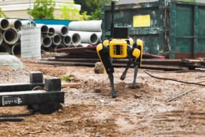
While its Walkthrough technology does not necessarily involve the use of unmanned aerial vehicles, the   BETA launch of DroneDeploy’s Ground Robotics solution represents the employment of another kind of robot, the walking kind.

With this new technology, users can send ground-based robots, such as rovers or quadrupeds on autonomous inspection missions. Equipped with payloads such as 360 cameras, thermal cameras, or gas sensors, the robots will capture data from their surrounding environment and send it back to the DroneDeploy platform for analysis.

The Ground Robotics application that DroneDeploy launched consists of three components: the robotics operations platform itself, cloud-based tele-operation and fully autonomous 360 Walkthrough.

The latter two components were demonstrated in a video presented at the DroneDeploy 21 Conference. David Inggs, DroneDeploy’s New Zealand-based head of Ground Robotics acted as pilot, while a Spot robot in the U.S. autonomously performed a simulated mission. “He drove the robot around using remote control from New Zealand via the cloud. Then he created an autonomous mission and then the drone stood up and walked around the set,” Pipe said.

Tele-operation gives the user the ability to wake up a robotic vehicle remotely, from virtually anywhere on earth and have it walk around and perform its inspection functions. The next level of remote operation is scheduled autonomous 360 walkthroughs. The robot wakes itself up at a predetermined time, walks around on the site, and captures a predetermined set of data and then returns to its home base and goes to sleep until it’s time for the next inspection.

Pipe predicted that the development of its Ground Robotics software would help usher in a robot-enabled future in the construction and other industries.

“There are going to be thousands of robots across many different settings, both industrial and commercial, but they’ll start with industrial settings where they’re collecting data on a schedule,” Pipe said. “They’re able to go anywhere a human can walk and capture that data.”

Read more about DroneDeploy’s movement towards a one-button process, work on disaster relief, and global expansion.

Jim Magill is a Houston-based writer with almost a quarter-century of experience covering technical and economic developments in the oil and gas industry. After retiring in December 2019 as a senior editor with S&P Global Platts, Jim began writing about emerging technologies, such as artificial intelligence, robots and drones, and the ways in which they’re contributing to our society. In addition to DroneLife, Jim is a contributor to Forbes.com and his work has appeared in the Houston Chronicle, U.S. News & World Report, and Unmanned Systems, a publication of the Association for Unmanned Vehicle Systems International.


Miriam McNabb

Miriam McNabb is the Editor-in-Chief of DRONELIFE and CEO of JobForDrones, a professional drone services marketplace, and a fascinated observer of the emerging drone industry and the regulatory environment for drones. Miriam has penned over 3,000 articles focused on the commercial drone space and is an international speaker and recognized figure in the industry.  Miriam has a degree from the University of Chicago and over 20 years of experience in high tech sales and marketing for new technologies.
For drone industry consulting or writing, Email Miriam.

TWITTER:@spaldingbarker

Subscribe to DroneLife here.

Filed Under: Applications, DL Exclusive, Drone News Feeds, News Tagged With: drone mapping, DroneDeploy, ground mapping, mapping for construction, photogrammetry

Reader Interactions

Trackbacks

  1. Drones pour l'énergie Solaire Résidentielle: Sunrun et DroneDeploy Trouvent un Moyen Plus Sûr et Plus Efficace de Mesurer les toits | Prestations drones, films institutionnels, journal en ligne says:
    December 19, 2021 at 10:30 am

    […] savoir plus sur DroneDeploy : Dronedeploy's nouvelle version et produits, financement et investissement, intervention en cas de catastrophe efforts et progrès vers un […]

    Reply
  2. Drones pour l'énergie Solaire Résidentielle: Sunrun et DroneDeploy Trouvent un Moyen Plus Sûr et Plus Efficace de Mesurer les toits - Askell Drone says:
    December 17, 2021 at 9:30 pm

    […] savoir plus sur DroneDeploy : Dronedeploy’s nouvelle version et produits, financement et investissement, intervention en cas de catastrophe efforts et progrès vers un […]

    Reply
  3. Drones for Residential Solar: Sunrun and DroneDeploy » Certified Drone Pilot says:
    December 17, 2021 at 6:24 pm

    […] more about DroneDeploy: DroneDeploy’s newest release and products, funding and investment, disaster response efforts, and progress towards one-button […]

    Reply
  4. Drones for Residential Photo voltaic: Sunrun and DroneDeploy - My Blog says:
    December 17, 2021 at 4:42 pm

    […] extra about DroneDeploy: DroneDeploy’s latest launch and merchandise, funding and funding, catastrophe response efforts, and progress in the direction of one-button […]

    Reply
  5. Drones for Residential Solar: Sunrun and DroneDeploy Find a Safer, More Efficient Way to Measure Rooftops | taktik(z) GDI (Government Defense Infrastructure) says:
    December 17, 2021 at 3:30 pm

    […] more about DroneDeploy: DroneDeploy’s newest release and products, funding and investment, disaster response efforts, and progress towards one-button […]

    Reply
  6. Drones for Residential Solar: Sunrun and DroneDeploy Find a Safer, More Efficient Way to Measure Rooftops - SkyDance Imaging says:
    December 17, 2021 at 2:04 pm

    […] more about DroneDeploy: DroneDeploy’s newest release and products, funding and investment, disaster response efforts, and progress towards one-button […]

    Reply
  7. Drones for Residential Solar: Sunrun and DroneDeploy | Livingo Group says:
    December 17, 2021 at 12:30 pm

    […] more about DroneDeploy: DroneDeploy’s newest release and products, funding and investment, disaster response efforts, and progress towards one-button […]

    Reply
  8. Drones for Residential Solar: Sunrun and DroneDeploy Find a Safer, More Efficient Way to Measure Rooftops - The Drone Page says:
    December 17, 2021 at 11:03 am

    […] more about DroneDeploy: DroneDeploy’s newest release and products, funding and investment, disaster response efforts, and progress towards one-button […]

    Reply
  9. DroneDeploy’s New Products Go Far Beyond Drones - DronesOnline.site says:
    November 6, 2021 at 11:36 pm

    […] post DroneDeploy’s New Products Go Far Beyond Drones appeared first on […]

    Reply
  10. DroneDeploy’s New Products Go Beyond Drones – Dronestagram Blog says:
    November 4, 2021 at 5:57 pm

    […] More… […]

    Reply
  11. DroneDeploy’s New Products Go Far Beyond Drones - Drone Films Limited says:
    November 4, 2021 at 9:17 am

    […] post DroneDeploy’s New Products Go Far Beyond Drones appeared first on […]

    Reply
  12. DroneDeploy’s New Products Go Beyond Drones – Game Up News says:
    November 4, 2021 at 8:28 am

    […] Source link […]

    Reply
  13. DroneDeploy’s New Products Go Far Beyond Drones – DronePilots.News says:
    November 4, 2021 at 8:26 am

    […] post DroneDeploy’s New Products Go Far Beyond Drones appeared first on […]

    Reply

Leave a Reply Cancel reply

Your email address will not be published. Required fields are marked *

Primary Sidebar

LATEST

Delair Unveils DT61 Long-Range Drone with Multi-Mission Capability

New fixed-wing VTOL platform expands Delair’s reach in civilian and defense applications Delair Introduces the DT61 for Extended-Range Operations Toulouse-based…

Continue Reading Delair Unveils DT61 Long-Range Drone with Multi-Mission Capability

Windracers and Aviation Sans Frontières Launch Humanitarian Drone Partnership

New Autonomous Cargo Drone Initiative Targets Medical Delivery in Remote African Communities Transforming Humanitarian Logistics with Drone Technology At the…

Continue Reading Windracers and Aviation Sans Frontières Launch Humanitarian Drone Partnership

Drone Company AIRO’s Stock Skyrockets After IPO Amid Growing Investor Interest

AIRO Group’s Stock Soars After IPO: What Investors Need to Know AIRO Group Holdings, a defense and aerospace technology company,…

Continue Reading Drone Company AIRO’s Stock Skyrockets After IPO Amid Growing Investor Interest

DJI Calls for Mandated Security Assessment as NDAA Deadline Approaches

DJI Urges Action on Overdue Security Audit DJI, the world’s largest drone manufacturer, has publicly called for the U.S. government…

Continue Reading DJI Calls for Mandated Security Assessment as NDAA Deadline Approaches

Can the U.S. Catch Up? Trump’s Executive Orders Aim to Spark Drone Manufacturing Boom

Administration Sets Lofty Goal to Ramp Up U.S. Drone Production By DRONELIFE Features Editor Jim Magill With its two recent…

Continue Reading Can the U.S. Catch Up? Trump’s Executive Orders Aim to Spark Drone Manufacturing Boom

Wingcopter Uses Ansys Simulation to Improve Drone Delivery of Medical Supplies [VIDEO]

Partnership Enhances Flight Range and Design for Remote Healthcare Acces Wingcopter Optimizes Drone Design for Long-Range Medical Delivery Wingcopter, a…

Continue Reading Wingcopter Uses Ansys Simulation to Improve Drone Delivery of Medical Supplies [VIDEO]

UAV Navigation–Grupo Oesía Joins EDF-Funded VANTAGE Project to Strengthen European Defense UAV Capabilities

Spanish firm to provide resilient guidance and navigation systems for next-gen tactical VTOL dron UAV Navigation Selected for Key Role…

Continue Reading UAV Navigation–Grupo Oesía Joins EDF-Funded VANTAGE Project to Strengthen European Defense UAV Capabilities

FlytBase and Esri Partner to Streamline Drone Data into GIS Workflows

New integration enables fully automated drone operations for real-time mapping and analysis in the ArcGIS ecosyste FlytBase and Esri Announce…

Continue Reading FlytBase and Esri Partner to Streamline Drone Data into GIS Workflows

Garuda Aerospace Opens India’s First Agri-Drone Indigenization Facility

Union Minister Kamlesh Paswan Launches Manufacturing Hub, 300 Training Centers, and DGCA-Certified Skill Program A Major Milestone for India’s Drone…

Continue Reading Garuda Aerospace Opens India’s First Agri-Drone Indigenization Facility

RedCliff Dominates Japan’s First National Drone Show Contest

Japan Drone Show Creativity Awards Highlight Innovation, Culture, and Social Impact Across the Country by DRONELIFE Staff Writer Ian J.…

Continue Reading RedCliff Dominates Japan’s First National Drone Show Contest

Secondary Sidebar

Footer

SPONSORED

Inspired Flight Gremsy IF800 VIO F1 drones geo week

What Will It Take to Strengthen U.S. Drone Manufacturing? A Conversation with Inspired Flight’s CEO

Global Mapper Mobile data collection

Collection Ground Control Points with Global Mapper Mobile

Military Drone Mapping Solutions

How SimActive’s Correlator3D™ is Revolutionizing Military Mapping: An Exclusive Interview with CEO Philippe Simard

Photogrammetry Accuracy Standards

SimActive Photogrammetry Software: Enabling Users to Meet Accuracy Standards for Over 20 Years

NACT Engineering Parrot ANAFI tether indoor shot

Smart Tether for Parrot ANAFI USA from NACT Engineering

Blue Marble, features global mapper, features Blue Marble

Check Out These New Features in Global Mapper v25 from Blue Marble

About Us | Contact Us | Advertise With Us | Write for Us | Privacy Policy | Terms of Service

The Trusted Source for the Business of Drones.

This website uses cookies and third party services. By clicking OK, you are agreeing to our privacy policy. ACCEPT

Manage consent

Privacy Overview

This website uses cookies to improve your experience while you navigate through the website. Out of these, the cookies that are categorized as necessary are stored on your browser as they are essential for the working of basic functionalities of the website. We also use third-party cookies that help us analyze and understand how you use this website. These cookies will be stored in your browser only with your consent. You also have the option to opt-out of these cookies. But opting out of some of these cookies may affect your browsing experience.
Necessary
Always Enabled
Necessary cookies are absolutely essential for the website to function properly. These cookies ensure basic functionalities and security features of the website, anonymously.
CookieDurationDescription
cookielawinfo-checkbox-analytics11 monthsThis cookie is set by GDPR Cookie Consent plugin. The cookie is used to store the user consent for the cookies in the category "Analytics".
cookielawinfo-checkbox-functional11 monthsThe cookie is set by GDPR cookie consent to record the user consent for the cookies in the category "Functional".
cookielawinfo-checkbox-necessary11 monthsThis cookie is set by GDPR Cookie Consent plugin. The cookies is used to store the user consent for the cookies in the category "Necessary".
cookielawinfo-checkbox-others11 monthsThis cookie is set by GDPR Cookie Consent plugin. The cookie is used to store the user consent for the cookies in the category "Other.
cookielawinfo-checkbox-performance11 monthsThis cookie is set by GDPR Cookie Consent plugin. The cookie is used to store the user consent for the cookies in the category "Performance".
viewed_cookie_policy11 monthsThe cookie is set by the GDPR Cookie Consent plugin and is used to store whether or not user has consented to the use of cookies. It does not store any personal data.
Functional
Functional cookies help to perform certain functionalities like sharing the content of the website on social media platforms, collect feedbacks, and other third-party features.
Performance
Performance cookies are used to understand and analyze the key performance indexes of the website which helps in delivering a better user experience for the visitors.
Analytics
Analytical cookies are used to understand how visitors interact with the website. These cookies help provide information on metrics the number of visitors, bounce rate, traffic source, etc.
Advertisement
Advertisement cookies are used to provide visitors with relevant ads and marketing campaigns. These cookies track visitors across websites and collect information to provide customized ads.
Others
Other uncategorized cookies are those that are being analyzed and have not been classified into a category as yet.
SAVE & ACCEPT