• Skip to main content
  • Skip to secondary menu
  • Skip to primary sidebar
  • Skip to secondary sidebar
  • Skip to footer
  • DroneRacingLife
  • DroneFlyers
  • Newsletter
DroneLife

DRONELIFE

Stay up to date on all the latest Drone News

  • News
  • Products
  • Industries
    • Agriculture
    • Construction
    • Delivery
    • Dual Use
    • Inspection
    • Public Safety
    • Surveying
  • Enthusiasts
  • Regulations
  • Business
  • Video
  • Podcasts

Visualskies: Meet the UK Studio Living Your Dream Job, Using Drones to Find Lost Cities

February 12, 2021 by Miriam McNabb 12 Comments

By DRONELIFE Staff Writer Jim Magill

Using drones, 3D scanning technology, LIDAR and other state-of-the-art technology for measuring, interpreting and visualizing data, a UK-based company has done everything from uncovering lost civilizations to creating augmented reality for movies and television.

Founded in 2014, Visualskies has grown from a company narrowly focused on capturing data from the air to a collaborative network of architects, archaeologists, surveyors and visual effects artists providing aerial- and ground-based filming and photography, high-definition 3D mapping and creating virtual- reality environments.

“We’ve developed an integrated system where we’re using terrestrial and aerial data-capture of all types — LIDAR, areal photogrammetry, heat-sensitive cameras, terrestrial laser scanners, terrestrial photogrammetry — and integrating those in the best way for our clients’ needs,” Duncan Lees, Visualskies 3D scanning specialist, said in an interview.

Visualskies

For its aerial photography, videography and other data-capture missions the company employs commercial drones, typically DJI M600 Pro and Inspire II Pro drones, which it equips with its own technology arrays.

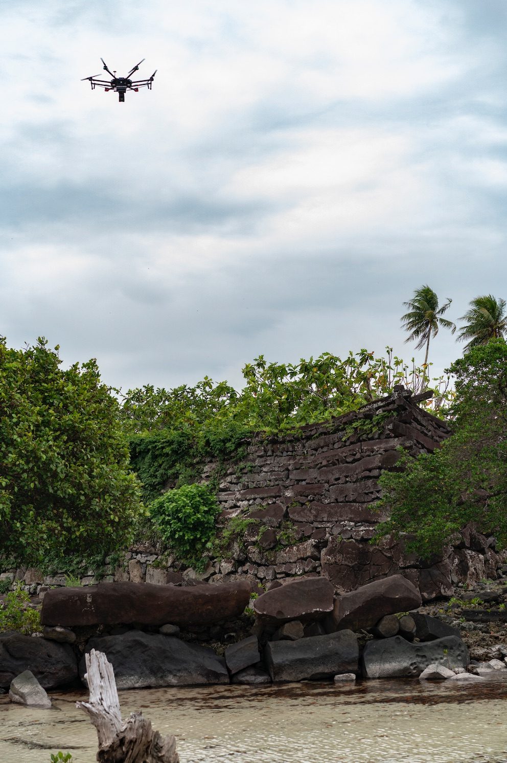
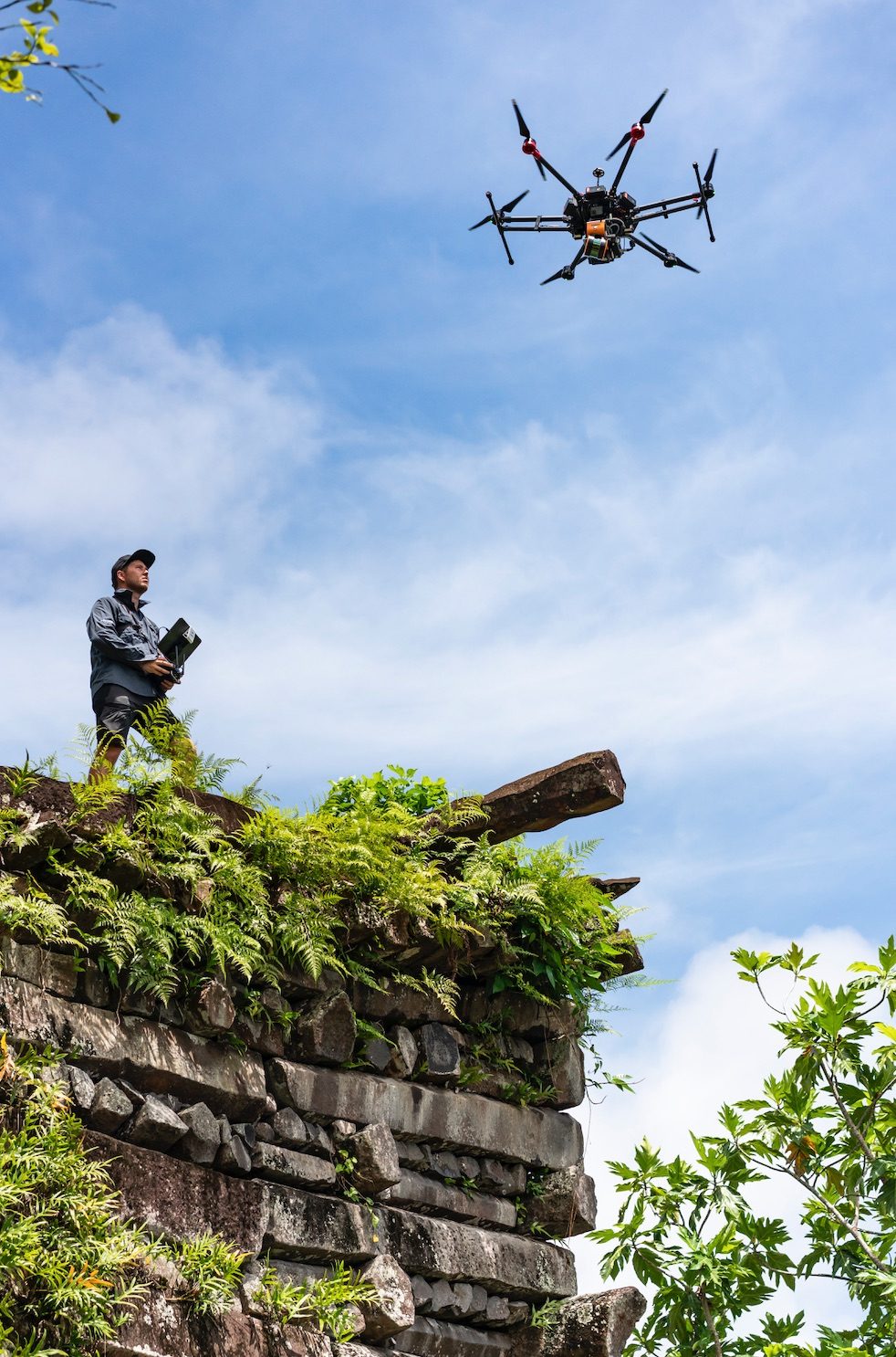
Among the most daunting challenges for Visualskies was taking part in the production of National Geographic’s TV series Lost Cities With Albert Lin, in which the company used its technology to reveal the remains of ancient civilizations in remote regions of the world, including the rugged rain forest in the coastal region of Northern Columbia and the dense jungles of Micronesia.

“We’re using technology that exists and adding bespoke developments,” Lees said. The Visualskies payload includes an array of multiple cameras on a specially engineered gimbal, which multiplies the amount of data that can be captured in a single flight. “Five cameras allow – instead of the normal photogrammatic process of capturing vertical and oblique shots – the collection of all of that information at once,” he said.

Mounting aerial LIDAR scanners on its drones gives the team “the ability to not just photograph from the air but also to use lasers to collect information,” Less said. “This is what has allowed us to penetrate the canopy in some of the heavily vegetated areas we were confronted with in the Lost Cities program.

Just getting to some of the sites of ancient, long-undiscovered ruins presented some special challenges for the team. “We were clambering up 4,000-meter mountains in Peru with heavy drone equipment and scanners and everything else,” Lees recalled.

In addition, given the tight time frame they were given for filming the series, the Visualskies team used its drone-mounted cameras and other data-capture equipment to record data while simultaneously shooting the visual images that would be shown in the series.

“The capture of information and the presenting of the information was all happening in the time scale as the programs were being filmed,” Lees said. “The reaction to the new discoveries we were making was real. It was true-to-life rather than a set-up several months later after a lot of processing had been done.”

As a result of the images and measurements taken from both the air and the ground, “people can get a sense of not only what the environment looks like now, but what it might look like with vegetation stripped away, and what it might have looked like 1,500 or 2,000 years ago when the archeological remains were being constructed,” Lees said.

Contributing to historic preservation

Currently the Visualskies team is working in the northernmost region of Scotland on a Netflix series, which Lees said would further test the limits of the company’s image- and data-capturing technology. Filming for the series, the title of which has not been released, combines elements of both virtual reality with actual real-life backgrounds.

“There are large landscapes here that are going to be utilized in the filming in a virtual production sense — LED walls with digital backgrounds that allow [the filmmakers] to film real elements but with a CGI background in real time,” he said. “We’re creating huge digital landscapes using data capture from the air and on the ground to capture mountains and heathland and heather-covered landscapes, and snow and rock into a single integrated whole.”

The company’s next project will take it from creating a new reality to documenting history in the real world. Visualskies is waiting for the final approval from the British government to take part in a conservation and historical restoration project at the Palace of Westminster, the historic building that is home to the two Houses of Parliament and which serves as the seat of Britain’s democratic government.

“We will be flying drones inside and outside of the structure as well as taking laser-scanning and digital photogrammetry to provide a perfect digital representation of the structure,” Lees said.

“There’s a huge interest in making sure the fabric of the building is maintained in the best possible way. We’ll be contributing to that by providing a digital record of the building that is millimetric-perfect and would reveal any problems that exist.”

The Visualskies team will fly drones both outside and inside the structure, as well as employ laser scanning and digital photogrammetry to create a digital representation of the building. The project will involve both autonomous and pilot-controlled drone flights.

“After initially scouting the site and deciding on the parameters of the site, we used preprogrammed flights,” Lees said. “The array is set up so we fly programmed flights in two different directions, so we get a crossing of all of the data.”

However, some of the flights, particularly those inside of the building, will be pilot-controlled “because there’s simply no way of being as precise as you need to be unless you’re fully in control of the drones,” Lees said.

Although the data-capture work will only comprise three or four days, because the team cannot fly drones when Parliament is in session, the length of the project might be spread out over a month or even two months. In addition, because of the historic nature of the site as well as the ever-present threat of terrorism in Britain, the Visualskies team will have to receive the highest level of security in order to complete the project, Lees said.

“We even have to load our equipment into a separate security vehicle that then takes our equipment in; and we have to go through a separate security system and take nothing in ourselves,” he said.

Lees said the company’s level of technological experience as well as the broad scope of life experiences among members of the Visualskies team has helped open the door for the team to pursue a wide range of different projects.

“Sometimes we’re creating a reality that is entirely fabricated and other times we’re documenting something that exists, and it’s often difficult to separate the two,” he said.

Miriam McNabb

Miriam McNabb is the Editor-in-Chief of DRONELIFE and CEO of JobForDrones, a professional drone services marketplace, and a fascinated observer of the emerging drone industry and the regulatory environment for drones. Miriam has penned over 3,000 articles focused on the commercial drone space and is an international speaker and recognized figure in the industry.  Miriam has a degree from the University of Chicago and over 20 years of experience in high tech sales and marketing for new technologies.
For drone industry consulting or writing, Email Miriam.

TWITTER:@spaldingbarker

Subscribe to DroneLife here.

Filed Under: Drone News Feeds, Featured, News Tagged With: drone GIS, drone LiDAR, drone mapping, drones for archeology, drones for architecture, Visualskies

Reader Interactions

Trackbacks

  1. Visualskies Finding Lost Cities with Drones - Go Drones Blog says:
    February 13, 2021 at 6:09 am

    […] Climbing cliffs, hacking through the jungle, finding lost cities: the awesome real life world of the drone operators at UK-based Visualskies. Source […]

    Reply
  2. Visualskies: Meet the UK Studio Living Your Dream Job, Using Drones to Find Lost Cities – Drones Crunch says:
    February 12, 2021 at 10:20 pm

    […] DRONELIFE […]

    Reply
  3. Visualskies: Meet the UK Studio Living Your Dream Job, Using Drones to Find Lost Cities - Drone Market says:
    February 12, 2021 at 5:21 pm

    […] Source […]

    Reply
  4. Visualskies: Meet the UK Studio Living Your Dream Job, Using Drones to Find Lost Cities – AWordPressSite says:
    February 12, 2021 at 3:47 pm

    […] post Visualskies: Meet the UK Studio Living Your Dream Job, Using Drones to Find Lost Cities appeared first on […]

    Reply
  5. Visualskies: Meet the UK Studio Living Your Dream Job, Using Drones to Find Lost Cities | taktik(z) GDI (Government Defense Infrastructure) says:
    February 12, 2021 at 11:11 am

    […] DroneLife source|articles […]

    Reply
  6. Visualskies: Meet the UK Studio Living Your Dream Job, Using Drones to Find Lost Cities – DronePilots.News says:
    February 12, 2021 at 10:26 am

    […] Source […]

    Reply
  7. Visualskies: Meet the UK Studio Living Your Dream Job, Using Drones to Find Lost Cities – Best Drones Online says:
    February 12, 2021 at 10:12 am

    […] post Visualskies: Meet the UK Studio Living Your Dream Job, Using Drones to Find Lost Cities appeared first on […]

    Reply
  8. Visualskies Finding Lost Cities with Drones – Game of Drones says:
    February 12, 2021 at 9:53 am

    […] Article Source […]

    Reply
  9. Visualskies: Meet the UK Studio Living Your Dream Job, Using Drones to Find Lost Cities | Drone Magazine says:
    February 12, 2021 at 9:31 am

    […] Source […]

    Reply
  10. Visualskies: Meet the UK Studio Living Your Dream Job, Using Drones to Find Lost Cities – DronePilots.News says:
    February 12, 2021 at 9:23 am

    […] post Visualskies: Meet the UK Studio Living Your Dream Job, Using Drones to Find Lost Cities appeared first on […]

    Reply
  11. Visualskies Discovering Misplaced Cities with Drones - Drone Market says:
    February 12, 2021 at 9:14 am

    […] Supply hyperlink […]

    Reply
  12. Visualskies Finding Lost Cities with Drones ⋆ Droni4K.com says:
    February 12, 2021 at 9:10 am

    […] The complete article is here […]

    Reply

Leave a Reply Cancel reply

Your email address will not be published. Required fields are marked *

Primary Sidebar

LATEST

WaiV Robotics Brings Autonomous Drone Recovery at Sea to U.S. Offshore Operators

As offshore energy assets move farther from shore, operators face growing challenges in inspection, maintenance, and emergency response. This week,…

Continue Reading WaiV Robotics Brings Autonomous Drone Recovery at Sea to U.S. Offshore Operators

Terra Drone Establishes Estonia-Based Defense Subsidiary to Support European Expansion

New company reflects broader shift from commercial drone services to defense and counter-drone systems Japan’s Terra Drone Corporation has established…

Continue Reading Terra Drone Establishes Estonia-Based Defense Subsidiary to Support European Expansion

NASA, UNOS and LifeNet Complete Successful BVLOS Drone Flights Carrying Human Kidneys

Study Examines Potential Role of Drones in Future Transplant Logistics All images, courtesy NASA. A new research collaboration between the…

Continue Reading NASA, UNOS and LifeNet Complete Successful BVLOS Drone Flights Carrying Human Kidneys

5 Federal Drone Policies Flying Under the Radar This Summer

From World Cup airspace restrictions to critical infrastructure rulemaking, several federal initiatives could shape the drone industry in the months…

Continue Reading 5 Federal Drone Policies Flying Under the Radar This Summer

Drone Industry Insights Launches the 9th Edition of the Global Drone Survey — The World’s Largest Annual Industry Survey for the Drone Market

Survey open to all actors in the global drone market ecosystem — manufacturers, operators, investors, associations, regulators, and service providers…

Continue Reading Drone Industry Insights Launches the 9th Edition of the Global Drone Survey — The World’s Largest Annual Industry Survey for the Drone Market

Proposed Patent Bill Could Have Major Implications for Drone Industry Intellectual Property

Prohibiting Adversarial Patents Act would make certain patents unenforceable while leaving ownership intact A newly introduced bill in Congress concerning…

Continue Reading Proposed Patent Bill Could Have Major Implications for Drone Industry Intellectual Property

Seattle Stadium “No-Drone Zone” During FIFA Matches

By Dronelife Features Editor Jim Magill Federal officials on Monday urged drone operators to stay away from Lumen Field, which…

Continue Reading Seattle Stadium “No-Drone Zone” During FIFA Matches

Landair Surveys Uses SimActive Correlator3D for Planned Burns Mapping in Australia

The Australian geospatial firm is using Correlator3D to generate orthomosaics from aerial imagery captured for wildfire prevention and land management…

Continue Reading Landair Surveys Uses SimActive Correlator3D for Planned Burns Mapping in Australia

As Disaster Risks Grow, WingXpand and Verizon Explore New Tools for Emergency Response

WingXpand will work with Verizon Frontline and emergency teams to explore new tools for disaster assessment and community resilience As…

Continue Reading As Disaster Risks Grow, WingXpand and Verizon Explore New Tools for Emergency Response

HOVERAir’s UK Launch Raises a Bigger Question: Who Will Serve America’s Consumer Drone Market?

HOVERAir has announced the UK launch of its new X1 Smart, a 99-gram self-flying camera designed to make aerial content…

Continue Reading HOVERAir’s UK Launch Raises a Bigger Question: Who Will Serve America’s Consumer Drone Market?

Secondary Sidebar

Footer

SPONSORED

Inspired Flight Gremsy IF800 VIO F1 drones geo week

What Will It Take to Strengthen U.S. Drone Manufacturing? A Conversation with Inspired Flight’s CEO

Global Mapper Mobile data collection

Collection Ground Control Points with Global Mapper Mobile

Military Drone Mapping Solutions

How SimActive’s Correlator3D™ is Revolutionizing Military Mapping: An Exclusive Interview with CEO Philippe Simard

Photogrammetry Accuracy Standards

SimActive Photogrammetry Software: Enabling Users to Meet Accuracy Standards for Over 20 Years

NACT Engineering Parrot ANAFI tether indoor shot

Smart Tether for Parrot ANAFI USA from NACT Engineering

Blue Marble, features global mapper, features Blue Marble

Check Out These New Features in Global Mapper v25 from Blue Marble

About Us | Contact Us | Advertise With Us | Write for Us | Privacy Policy | Terms of Service

The Trusted Source for the Business of Drones.

This website uses cookies and third party services. By clicking OK, you are agreeing to our privacy policy. ACCEPT

Manage consent

Privacy Overview

This website uses cookies to improve your experience while you navigate through the website. Out of these, the cookies that are categorized as necessary are stored on your browser as they are essential for the working of basic functionalities of the website. We also use third-party cookies that help us analyze and understand how you use this website. These cookies will be stored in your browser only with your consent. You also have the option to opt-out of these cookies. But opting out of some of these cookies may affect your browsing experience.
Necessary
Always Enabled
Necessary cookies are absolutely essential for the website to function properly. These cookies ensure basic functionalities and security features of the website, anonymously.
CookieDurationDescription
cookielawinfo-checkbox-analytics11 monthsThis cookie is set by GDPR Cookie Consent plugin. The cookie is used to store the user consent for the cookies in the category "Analytics".
cookielawinfo-checkbox-functional11 monthsThe cookie is set by GDPR cookie consent to record the user consent for the cookies in the category "Functional".
cookielawinfo-checkbox-necessary11 monthsThis cookie is set by GDPR Cookie Consent plugin. The cookies is used to store the user consent for the cookies in the category "Necessary".
cookielawinfo-checkbox-others11 monthsThis cookie is set by GDPR Cookie Consent plugin. The cookie is used to store the user consent for the cookies in the category "Other.
cookielawinfo-checkbox-performance11 monthsThis cookie is set by GDPR Cookie Consent plugin. The cookie is used to store the user consent for the cookies in the category "Performance".
viewed_cookie_policy11 monthsThe cookie is set by the GDPR Cookie Consent plugin and is used to store whether or not user has consented to the use of cookies. It does not store any personal data.
Functional
Functional cookies help to perform certain functionalities like sharing the content of the website on social media platforms, collect feedbacks, and other third-party features.
Performance
Performance cookies are used to understand and analyze the key performance indexes of the website which helps in delivering a better user experience for the visitors.
Analytics
Analytical cookies are used to understand how visitors interact with the website. These cookies help provide information on metrics the number of visitors, bounce rate, traffic source, etc.
Advertisement
Advertisement cookies are used to provide visitors with relevant ads and marketing campaigns. These cookies track visitors across websites and collect information to provide customized ads.
Others
Other uncategorized cookies are those that are being analyzed and have not been classified into a category as yet.
SAVE & ACCEPT