• Skip to main content
  • Skip to secondary menu
  • Skip to primary sidebar
  • Skip to secondary sidebar
  • Skip to footer
  • DroneRacingLife
  • DroneFlyers
  • Newsletter
DroneLife

DRONELIFE

Stay up to date on all the latest Drone News

  • News
  • Products
  • Industries
    • Agriculture
    • Construction
    • Delivery
    • Dual Use
    • Inspection
    • Public Safety
    • Surveying
  • Enthusiasts
  • Regulations
  • Business
  • Video
  • Podcasts

Mercatus Center: Drone Highways are the Road to Commercial Drone Integration

January 18, 2021 by Miriam McNabb 9 Comments

drone highwaysRecent research from the Mercatus Center argues that drone highways situated over existing public roads could be the fastest way to full integration of commercial drones.

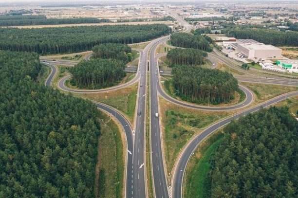
The Mercatus Center research, written by senior fellow Brent Skorup and Harvard University JD student Connor Haaland rank the 50 U.S. states in terms of readiness for the drone industry.  The researchers cite significant “ambiguity in federal and state roles over airspace management for drones” as a major barrier to readiness.   The researchers see a solution, however: an agreement between federal and state governments to implement “drone highways” over existing public roads.

Drone technology has made major strides: autonomy, safety, reliability and ruggedness have all improved.   Drone regulations have also moved forward: remote ID, flight at night, and flight over people and vehicles have all been regularized.  Before commercial drones can be fully integrated into the airspace over communities, however, the often discussed gray areas of public airspace over private property must be made clear.  The Mercatus report ranks the 50 states on readiness for commercial drones based on the following criteria:

  1. Airspace lease law (30 points): Drone highways must be demarcated by regulators and safely separated from airports, homes, schools, and other sensitive locations. Leasing airspace above public property would accelerate drone services because creating flight paths over backyards and private lands raises issues about the taking of private property.

  2. Law vesting air rights with landowners (10 points): This clarifies that the state is exercising its police powers and defining property rights—and puts drone operators and residents on notice about the extent of those rights. Where state or local authorities own public rights-of-way, air rights laws recognize their property interest in the aerial corridors above public roads.

  3. Avigation easement law (25 points): This allows drones to operate as long as they are high enough not to bother landowners and passersby. If the state or municipality does not own aerial corridors above public roads, drones can still generally access the aerial easements if state officials demarcate drone highways above public roads.

  4. Drone task force or program office (20 points): These bodies help anticipate (and address) issues such as zoning rules, noise limits, time-of-day restrictions, insurance, and privacy for private dwellings.

  5. Drone jobs estimate (15 points): The number of drone jobs per 100,000 residents is a proxy for soft factors (e.g., a college offering drone programs or workers in the aerospace industry) that can position states for future jobs and services growth.

From these, Skorup and Haaland find that states with exceptional drone rules are North Dakota, Arkansas, Oklahoma, Nevada, and Virginia. The states with the most room for improvement are Nebraska, Rhode Island, Iowa, Mississippi, and Kentucky.

While it would not resolve all of the issues, allowing drones to fly over public roads could make it easier for commercial drone operations to find clarity – quickly and easily – over where flight is and is not allowed.

Miriam McNabb

Miriam McNabb is the Editor-in-Chief of DRONELIFE and CEO of JobForDrones, a professional drone services marketplace, and a fascinated observer of the emerging drone industry and the regulatory environment for drones. Miriam has penned over 3,000 articles focused on the commercial drone space and is an international speaker and recognized figure in the industry.  Miriam has a degree from the University of Chicago and over 20 years of experience in high tech sales and marketing for new technologies.
For drone industry consulting or writing, Email Miriam.

TWITTER:@spaldingbarker

Subscribe to DroneLife here.

Filed Under: Drone News Feeds, News Tagged With: drone highways, Drone Industry, drone laws, Drone Research, Mercatus Center

Reader Interactions

Trackbacks

  1. Drone Highways Road to Commercial Drone Integration - Go Drones Blog says:
    January 19, 2021 at 12:33 am

    […] Mercatus Center research suggests that drone highways could be the fastest way to eliminate “ambiguity” in state and federal drone regs. Source […]

    Reply
  2. Mercatus Heart: Drone Highways are the Street to Industrial Drone Integration - Drone Market says:
    January 18, 2021 at 4:09 pm

    […] Supply […]

    Reply
  3. Mercatus Center: Drone Highways are the Road to Commercial Drone Integration - Drone Market says:
    January 18, 2021 at 4:08 pm

    […] Source […]

    Reply
  4. Drone Highways Road To Commercial Drone Integration » Drones Today says:
    January 18, 2021 at 12:32 pm

    […] Original Article […]

    Reply
  5. Mercatus Center: Drone Highways are the Road to Commercial Drone Integration – DronePilots.News says:
    January 18, 2021 at 12:25 pm

    […] post Mercatus Center: Drone Highways are the Road to Commercial Drone Integration appeared first on […]

    Reply
  6. Mercatus Center: Drone Highways are the Road to Commercial Drone Integration | Drone Magazine says:
    January 18, 2021 at 12:21 pm

    […] Source […]

    Reply
  7. Drone Highways Road to Commercial Drone Integration ⋆ Droni4K.com says:
    January 18, 2021 at 12:10 pm

    […] The complete article is here […]

    Reply
  8. Mercatus Center: Drone Highways are the Road to Commercial Drone Integration – Best Drones Online says:
    January 18, 2021 at 11:41 am

    […] post Mercatus Center: Drone Highways are the Road to Commercial Drone Integration appeared first on […]

    Reply
  9. Mercatus Center: Drone Highways Are The Road To Commercial Drone Integration » Drones Today says:
    January 18, 2021 at 11:38 am

    […] Original Article […]

    Reply

Leave a Reply Cancel reply

Your email address will not be published. Required fields are marked *

Primary Sidebar

LATEST

Designing the Optimal Drone: How HP Additive Manufacturing Enables Speed, Scale, and Supply-Chain Flexibility

The drone industry is under pressure from multiple directions at once. Manufacturers are expected to move faster, iterate more often,…

Continue Reading Designing the Optimal Drone: How HP Additive Manufacturing Enables Speed, Scale, and Supply-Chain Flexibility

TRIPLE7 and JR West Test Heavy-Lift Drone Logistics on Japan’s Hokuriku Shinkansen

This article published in collaboration with JUIDA, the Japan UAS Industrial Development Association.     Tokyo-based drone operator TRIPLE7 completed a…

Continue Reading TRIPLE7 and JR West Test Heavy-Lift Drone Logistics on Japan’s Hokuriku Shinkansen

Vector and Nammo Partner on Kinetically-Integrated UAS Platforms

Vector, a Bluffdale, Utah-based defense-as-a-service company, has announced an agreement with Nammo Defense Systems Inc. to integrate and supply munitions…

Continue Reading Vector and Nammo Partner on Kinetically-Integrated UAS Platforms

Unprepared for Drone War? Europe and the US Face Procurement Crisis

Military drone procurement is becoming one of the defining defense challenges of this decade. Europe is confronting a paradox at…

Continue Reading Unprepared for Drone War? Europe and the US Face Procurement Crisis

Designing Resilient Roads on Java’s Southern Coast: A Blue Marble Geographics Case Study

As governments invest in infrastructure to unlock tourism and regional growth, the challenge is no longer just building roads. It…

Continue Reading Designing Resilient Roads on Java’s Southern Coast: A Blue Marble Geographics Case Study

Woolpert and Saildrone Deploy Autonomous USV for NOAA Seafloor Mapping Near Mariana Islands

Woolpert and Saildrone have partnered to collect and process bathymetric survey data for NOAA’s Ocean Exploration and Office of Coast…

Continue Reading Woolpert and Saildrone Deploy Autonomous USV for NOAA Seafloor Mapping Near Mariana Islands

Canada’s Defence Industry Unites: ACDC Launches to Advocate for Autonomous and Drone Capabilities

A new trade association is giving Canadian defense technology companies — including drone and autonomous systems developers — a unified…

Continue Reading Canada’s Defence Industry Unites: ACDC Launches to Advocate for Autonomous and Drone Capabilities

March Public Safety Drone Review: NUSTL Experts to Address Counter-UAS and FIFA World Cup Security

Register here to join the live broadcast on Tuesday, March 3 at 3 p.m. EST. March Public Safety Drone Review…

Continue Reading March Public Safety Drone Review: NUSTL Experts to Address Counter-UAS and FIFA World Cup Security

Epirus and Digital Force Technologies Partner on Integrated Counter-UAS Kill Chain

Epirus and Digital Force Technologies (DFT) have announced a partnership to deliver a fully integrated counter-UAS kill chain, unifying their…

Continue Reading Epirus and Digital Force Technologies Partner on Integrated Counter-UAS Kill Chain

TV Asahi and KDDI Smart Drone Partner for Disaster News Drone Deployment

This article published in collaboration with JUIDA, the Japan UAS Industrial Development Association.     TV Asahi and KDDI Smart Drone…

Continue Reading TV Asahi and KDDI Smart Drone Partner for Disaster News Drone Deployment

Secondary Sidebar

Footer

SPONSORED

Inspired Flight Gremsy IF800 VIO F1 drones geo week

What Will It Take to Strengthen U.S. Drone Manufacturing? A Conversation with Inspired Flight’s CEO

Global Mapper Mobile data collection

Collection Ground Control Points with Global Mapper Mobile

Military Drone Mapping Solutions

How SimActive’s Correlator3D™ is Revolutionizing Military Mapping: An Exclusive Interview with CEO Philippe Simard

Photogrammetry Accuracy Standards

SimActive Photogrammetry Software: Enabling Users to Meet Accuracy Standards for Over 20 Years

NACT Engineering Parrot ANAFI tether indoor shot

Smart Tether for Parrot ANAFI USA from NACT Engineering

Blue Marble, features global mapper, features Blue Marble

Check Out These New Features in Global Mapper v25 from Blue Marble

About Us | Contact Us | Advertise With Us | Write for Us | Privacy Policy | Terms of Service

The Trusted Source for the Business of Drones.

This website uses cookies and third party services. By clicking OK, you are agreeing to our privacy policy. ACCEPT

Manage consent

Privacy Overview

This website uses cookies to improve your experience while you navigate through the website. Out of these, the cookies that are categorized as necessary are stored on your browser as they are essential for the working of basic functionalities of the website. We also use third-party cookies that help us analyze and understand how you use this website. These cookies will be stored in your browser only with your consent. You also have the option to opt-out of these cookies. But opting out of some of these cookies may affect your browsing experience.
Necessary
Always Enabled
Necessary cookies are absolutely essential for the website to function properly. These cookies ensure basic functionalities and security features of the website, anonymously.
CookieDurationDescription
cookielawinfo-checkbox-analytics11 monthsThis cookie is set by GDPR Cookie Consent plugin. The cookie is used to store the user consent for the cookies in the category "Analytics".
cookielawinfo-checkbox-functional11 monthsThe cookie is set by GDPR cookie consent to record the user consent for the cookies in the category "Functional".
cookielawinfo-checkbox-necessary11 monthsThis cookie is set by GDPR Cookie Consent plugin. The cookies is used to store the user consent for the cookies in the category "Necessary".
cookielawinfo-checkbox-others11 monthsThis cookie is set by GDPR Cookie Consent plugin. The cookie is used to store the user consent for the cookies in the category "Other.
cookielawinfo-checkbox-performance11 monthsThis cookie is set by GDPR Cookie Consent plugin. The cookie is used to store the user consent for the cookies in the category "Performance".
viewed_cookie_policy11 monthsThe cookie is set by the GDPR Cookie Consent plugin and is used to store whether or not user has consented to the use of cookies. It does not store any personal data.
Functional
Functional cookies help to perform certain functionalities like sharing the content of the website on social media platforms, collect feedbacks, and other third-party features.
Performance
Performance cookies are used to understand and analyze the key performance indexes of the website which helps in delivering a better user experience for the visitors.
Analytics
Analytical cookies are used to understand how visitors interact with the website. These cookies help provide information on metrics the number of visitors, bounce rate, traffic source, etc.
Advertisement
Advertisement cookies are used to provide visitors with relevant ads and marketing campaigns. These cookies track visitors across websites and collect information to provide customized ads.
Others
Other uncategorized cookies are those that are being analyzed and have not been classified into a category as yet.
SAVE & ACCEPT