• Skip to main content
  • Skip to secondary menu
  • Skip to primary sidebar
  • Skip to secondary sidebar
  • Skip to footer
  • DroneRacingLife
  • DroneFlyers
  • Newsletter
DroneLife

DRONELIFE

Stay up to date on all the latest Drone News

  • News
  • Products
  • Industries
    • Agriculture
    • Construction
    • Delivery
    • Dual Use
    • Inspection
    • Public Safety
    • Surveying
  • Enthusiasts
  • Regulations
  • Business
  • Video
  • Podcasts

Drone Harmony Upgrade Terrain Aware Platforms

August 5, 2020 by Jason Reagan 5 Comments

Drone Harmony terrain aware
Source: Drone Harmony

Switzerland-based Drone Harmony is upgrading its line of terrain aware flight planning platforms to better account for differences in elevation – a key requirement in many industries from surveying to mining inspection.

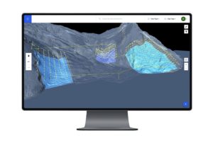
Several drone systems gather 3D data geographic data for analysis and, with this growth, the availability and use of terrain data is expanding quickly. Drone Harmony’s new upgrade offers automated terrain-aware missions planning by using both custom terrain maps, as well as the newly integrated Airbus 12-meter grid global data set.

“Customers that do not have custom terrain can profit from a global source of accurate terrain data without ever leaving the Drone Harmony application,” a Drone Harmony spokesperson said. “With a few clicks in the web interface, customers can pull terrain data anywhere in the world and start planning missions.”

The upgraded platform also boasts a combination of flexible import options together with 3D DEM view and a rich new plan catalog for terrain aware flight planning.

“Drone Harmony Web makes it the most comprehensive tool for mapping and inspection in complex terrains. Furthermore, larger organizations with massive amounts of terrain data can profit from a built-in terrain streaming feature in Drone Harmony Web. This feature enables such customers to work with huge terrain models hassle-free, without the need to load terrain models in parts and worry about memory and processing limits.”

Past Success

Last year, Drone Harmony joined the ESA Business Incubator Switzerland, allowing the start-up to upgrade its UAS missions-planning platforms using satellite data.

In 2018, Drone Harmony developed Cell Tower Scan, an Android app that uses the company’s UAV planning framework to complete cell-tower inspections in 5-10 minutes using quadcopters.

Drone Harmony works with several industry partners on drone workflow automation for various industrial use cases, including Bentley System’s Reality Modelling team, SiteSee (AUS), The iGlobe Group (RSA), VertSpec (USA) and EasyInspect (Denmark), as well as dozens of customers and resellers around the world.


Jason Reagan
Jason Reagan

Jason is a longstanding contributor to DroneLife with an avid interest in all things tech. He focuses on anti-drone technologies and the public safety sector; police, fire, and search and rescue.

Beginning his career as a journalist in 1996, Jason has since written and edited thousands of engaging news articles, blog posts, press releases and online content.

Email Jason
TWITTER:@JasonPReagan

LinkedIn 

Subscribe to DroneLife here.

Filed Under: Drone News, Drone News Feeds, Inspection, News Tagged With: Drone Harmony

Reader Interactions

Trackbacks

  1. Drone Harmony Upgrade Terrain Aware Platforms - Go Drones Blog says:
    August 6, 2020 at 12:56 am

    […] Switzerland-based Drone Harmony is upgrading its line of terrain aware flight planning platforms to better account for differences in elevation. Source […]

    Reply
  2. Drone Harmony Upgrade Terrain Aware Platforms – Top Drones & reviews says:
    August 5, 2020 at 11:05 pm

    […] post Drone Harmony Upgrade Terrain Aware Platforms appeared first on […]

    Reply
  3. Drone Harmony Upgrade Terrain Aware Platforms ⋆ says:
    August 5, 2020 at 7:38 pm

    […] The complete article is here […]

    Reply
  4. Drone Harmony Upgrade Terrain Aware Platforms - Eledonk Electronics says:
    August 5, 2020 at 7:12 pm

    […] post Drone Harmony Upgrade Terrain Aware Platforms appeared first on […]

    Reply
  5. Drone Harmony Upgrade Terrain Aware Platforms | Drone Magazine says:
    August 5, 2020 at 5:11 pm

    […] Source […]

    Reply

Leave a Reply Cancel reply

Your email address will not be published. Required fields are marked *

Primary Sidebar

LATEST

Can Drones Replace High-Speed Police Pursuits? BRINC’s Guardian Points to a New Model

At the recent Motorola Solutions [NYSE: MSI], BRINC CEO Blake Resnick outlined a vision that challenges one of policing’s most…

Continue Reading Can Drones Replace High-Speed Police Pursuits? BRINC’s Guardian Points to a New Model

Can America Build a Fully Domestic Drone? Lithium Discovery Moves the Needle

New USGS findings highlight potential for domestic lithium supply, but key gaps remain in the battery chain A new study…

Continue Reading Can America Build a Fully Domestic Drone? Lithium Discovery Moves the Needle

Public Safety Drone Review: May 5, 2026 with BRINC CEO Blake Resnick

Join the Live Discussion on May 5 Register here for the May Public Safety Drone Review. The next Public Safety…

Continue Reading Public Safety Drone Review: May 5, 2026 with BRINC CEO Blake Resnick

Lawmakers Urge Expanded National Guard Role for Drone Security at 2026 FIFA World Cup

Letter calls for unified federal approach to counter-UAS operations across U.S. host cities U.S. lawmakers are calling on the federal…

Continue Reading Lawmakers Urge Expanded National Guard Role for Drone Security at 2026 FIFA World Cup

Skydio Raises $110M Series F, Signals Strong Revenue and U.S. Manufacturing Push

CEO Adam Bry highlights reduced capital needs as company expands production and commits billions to domestic manufacturing Skydio has raised…

Continue Reading Skydio Raises $110M Series F, Signals Strong Revenue and U.S. Manufacturing Push

Teledyne FLIR Defense Expands Payload Program with Emesent Hovermap for GPS-Denied Operations

New integration brings LiDAR mapping and radiation detection together across air and ground platforms Teledyne FLIR Defense has expanded its…

Continue Reading Teledyne FLIR Defense Expands Payload Program with Emesent Hovermap for GPS-Denied Operations

ideaForge Signs MoU with Japan’s DMP to Develop AI Drones

India’s largest UAV maker partners with Tokyo-based Digital Media Professionals to integrate edge AI silicon and enter the Japanese defense…

Continue Reading ideaForge Signs MoU with Japan’s DMP to Develop AI Drones

WISPR Systems’ SkyScout 2+ Earns Blue UAS Cleared List Approval

WISPR Systems’ SkyScout 2+ receives Blue UAS Cleared List designation from DCMA, validating the platform for federal, public safety, and…

Continue Reading WISPR Systems’ SkyScout 2+ Earns Blue UAS Cleared List Approval

SkyfireAI Raises $11M to Advance Autonomous Multi-Drone Operations for Public Safety

New platform aims to reduce operator workload while enabling coordinated drone response at scale SkyfireAI has announced an $11 million…

Continue Reading SkyfireAI Raises $11M to Advance Autonomous Multi-Drone Operations for Public Safety

What Starlink Actually Changes for Police Drones: A Look at BRINC’s Guardian

BRINC Guardian with Starlink: A New Standard for Drone as First Responder?Satellite connectivity, redundancy, and real-world range could reshape police…

Continue Reading What Starlink Actually Changes for Police Drones: A Look at BRINC’s Guardian

Secondary Sidebar

Footer

SPONSORED

Inspired Flight Gremsy IF800 VIO F1 drones geo week

What Will It Take to Strengthen U.S. Drone Manufacturing? A Conversation with Inspired Flight’s CEO

Global Mapper Mobile data collection

Collection Ground Control Points with Global Mapper Mobile

Military Drone Mapping Solutions

How SimActive’s Correlator3D™ is Revolutionizing Military Mapping: An Exclusive Interview with CEO Philippe Simard

Photogrammetry Accuracy Standards

SimActive Photogrammetry Software: Enabling Users to Meet Accuracy Standards for Over 20 Years

NACT Engineering Parrot ANAFI tether indoor shot

Smart Tether for Parrot ANAFI USA from NACT Engineering

Blue Marble, features global mapper, features Blue Marble

Check Out These New Features in Global Mapper v25 from Blue Marble

About Us | Contact Us | Advertise With Us | Write for Us | Privacy Policy | Terms of Service

The Trusted Source for the Business of Drones.

This website uses cookies and third party services. By clicking OK, you are agreeing to our privacy policy. ACCEPT

Manage consent

Privacy Overview

This website uses cookies to improve your experience while you navigate through the website. Out of these, the cookies that are categorized as necessary are stored on your browser as they are essential for the working of basic functionalities of the website. We also use third-party cookies that help us analyze and understand how you use this website. These cookies will be stored in your browser only with your consent. You also have the option to opt-out of these cookies. But opting out of some of these cookies may affect your browsing experience.
Necessary
Always Enabled
Necessary cookies are absolutely essential for the website to function properly. These cookies ensure basic functionalities and security features of the website, anonymously.
CookieDurationDescription
cookielawinfo-checkbox-analytics11 monthsThis cookie is set by GDPR Cookie Consent plugin. The cookie is used to store the user consent for the cookies in the category "Analytics".
cookielawinfo-checkbox-functional11 monthsThe cookie is set by GDPR cookie consent to record the user consent for the cookies in the category "Functional".
cookielawinfo-checkbox-necessary11 monthsThis cookie is set by GDPR Cookie Consent plugin. The cookies is used to store the user consent for the cookies in the category "Necessary".
cookielawinfo-checkbox-others11 monthsThis cookie is set by GDPR Cookie Consent plugin. The cookie is used to store the user consent for the cookies in the category "Other.
cookielawinfo-checkbox-performance11 monthsThis cookie is set by GDPR Cookie Consent plugin. The cookie is used to store the user consent for the cookies in the category "Performance".
viewed_cookie_policy11 monthsThe cookie is set by the GDPR Cookie Consent plugin and is used to store whether or not user has consented to the use of cookies. It does not store any personal data.
Functional
Functional cookies help to perform certain functionalities like sharing the content of the website on social media platforms, collect feedbacks, and other third-party features.
Performance
Performance cookies are used to understand and analyze the key performance indexes of the website which helps in delivering a better user experience for the visitors.
Analytics
Analytical cookies are used to understand how visitors interact with the website. These cookies help provide information on metrics the number of visitors, bounce rate, traffic source, etc.
Advertisement
Advertisement cookies are used to provide visitors with relevant ads and marketing campaigns. These cookies track visitors across websites and collect information to provide customized ads.
Others
Other uncategorized cookies are those that are being analyzed and have not been classified into a category as yet.
SAVE & ACCEPT