• Skip to main content
  • Skip to secondary menu
  • Skip to primary sidebar
  • Skip to secondary sidebar
  • Skip to footer
  • DroneRacingLife
  • DroneFlyers
  • Newsletter
DroneLife

DRONELIFE

Stay up to date on all the latest Drone News

  • News
  • Products
  • Industries
    • Agriculture
    • Construction
    • Delivery
    • Dual Use
    • Inspection
    • Public Safety
    • Surveying
  • Enthusiasts
  • Regulations
  • Business
  • Video
  • Podcasts

SimActive Used to Determine Solar Potential from Satellite Imagery

April 8, 2020 by Harry McNabb 4 Comments

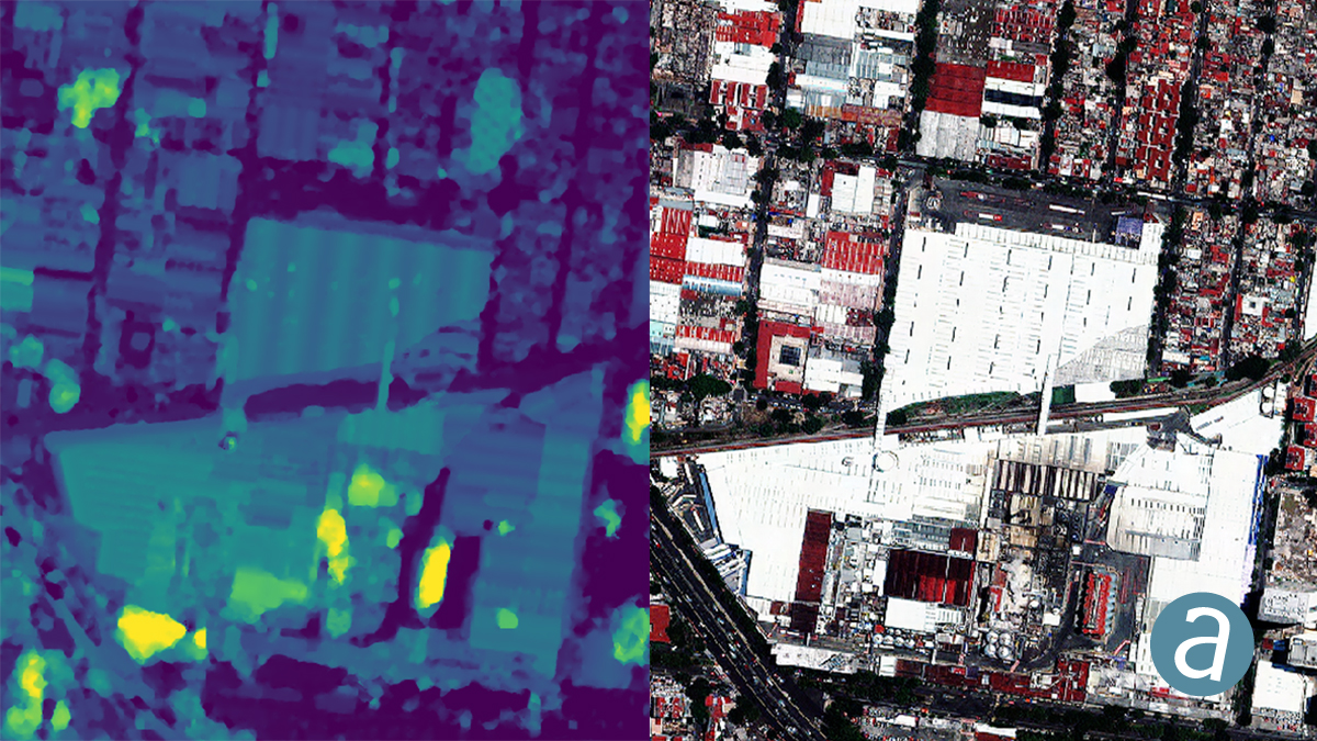
In a recent press release,  SimActive Inc., a world-leading developer of photogrammetry software, announces that their Correlator3D™ product is being used by Dutch company NEO B.V. to assess solar potential in multiple cities.  Digital surface models (DSMs) are generated from WorldView and GeoEye satellite stereo images and serve to calculate solar panel capacity.

DSMs covering hundreds of square kilometres are quickly generated by the software.  Key metrics to estimate solar potential are then derived, including roof orientation, pitch and shaded areas.

“We have been impressed by the quality of SimActive’s DSMs, especially considering the limited spatial resolution of the imagery”, said Rob Beck, Managing Director at NEO B.V. “Another definite advantage of Correlator3D is the simplicity of the workflow, making it easy to use by our team.”

About NEO B.V.

NEO is an innovative independent Dutch company established in 1996. The focus has always been on the automated production of image-based Calls-to-Action for customers, enabling better decisions and increasing efficiency. NEO operates in markets for information services in agriculture, environment, infrastructure management (pipelines, etc.) and the updating of map-based registrations. Most of our turnover is created in The Netherlands, but NEO works on 4 continents. See www.neo.nl. There is a scoop: NEO is the first company on the planet to assimilate multiple VHR-satellite coverages per year for an entire country (The Netherlands). The imagery is used to detect changes in all buildings, trees, roads, water courses and sometimes smaller objects as solar panels. From the detected spatial changes CtA’s are produced for hundreds of customers. See www.neo.nl/SIG4EO.

About SimActive

SimActive is the developer of Correlator3D™ software, a patented end-to-end photogrammetry solution for the generation of high-quality geospatial data from satellite and aerial imagery, including UAVs. Correlator3D™ performs aerial triangulation (AT) and produces dense digital surface models (DSM), digital terrain models (DTM), point clouds, orthomosaics, 3D models and vectorized 3D features. Powered by GPU technology and multi-core CPUs, Correlator3D™ ensures matchless processing speed to support rapid production of large datasets. SimActive has been selling Correlator3D™ to leading mapping firms and government organizations around the world, offering cutting-edge photogrammetry software backed by exceptional customer support. For more information, visit www.simactive.com.

Harry McNabb
Harry McNabb

CEO DroneLife.com, DroneRacingLife.com, and CMO of Jobfordrones.com. Principle at Spalding Barker Strategies. Has enjoyed working with and around the commercial drone industry for the last 10 years.   Attendance and speaker at Industry Events such as Commercial UAV, InterGeo, Interdrone and others.   Proud father of two. Enjoys karate, Sherlock Holmes, and interesting things.  Subscribe to all things drone at DroneLife here. Email is Harry@dronelife.com.   Make Sure that you WhiteList us in your email to make sure you get our Newsletter.  Editor1@dronelife.com.

Filed Under: Applications, News Tagged With: 3d correlator, NEO, SimActive

Reader Interactions

Trackbacks

  1. » SimActive Used to Determine Solar Potential from Satellite Imagery – DroneLifesolarequipmentinstaller.com says:
    April 8, 2020 at 5:24 pm

    […] Source: https://dronelife.com/2020/04/08/simactive-used-to-determine-solar-potential-from-satellite-imagery/ […]

    Reply
  2. SimActive Used to Decide Photo voltaic Potential from Satellite tv for pc Imagery - Drone Stuff Pro says:
    April 8, 2020 at 5:04 pm

    […] Supply hyperlink […]

    Reply
  3. SimActive Used to Determine Solar Potential from Satellite Imagery | Drone Magazine says:
    April 8, 2020 at 3:17 pm

    […] Source […]

    Reply
  4. SimActive Used to Determine Solar Potential from Satellite Imagery | Gadgets says:
    April 8, 2020 at 2:57 pm

    […] Source link […]

    Reply

Leave a Reply Cancel reply

Your email address will not be published. Required fields are marked *

Primary Sidebar

LATEST

Michigan’s Bet on the Low Altitude Economy: How M Air Connects Aerospace Innovation and Detroit Manufacturing

At XPONENTIAL 2026 this week, leaders from University of Michigan outlined an ambitious vision for the future of drones and…

Continue Reading Michigan’s Bet on the Low Altitude Economy: How M Air Connects Aerospace Innovation and Detroit Manufacturing

CVS, SkyfireAI, and Thales Outline Drone-Based Healthcare Response Network at XPONENTIAL 2026

Panel highlights healthcare logistics, emergency response, and disaster resilience as key drone use cases At the XPONENTIAL 2026 conference in…

Continue Reading CVS, SkyfireAI, and Thales Outline Drone-Based Healthcare Response Network at XPONENTIAL 2026

Drone Dominance: The Defense Department’s Push to Build a Scalable U.S. Drone Supply Chain

At this morning’s keynote roundtable at XPONENTIAL 2026, government and industry leaders outlined a new phase in the effort to…

Continue Reading Drone Dominance: The Defense Department’s Push to Build a Scalable U.S. Drone Supply Chain

From The Floor of XPONENTIAL: AIRO and Jaunt Reveal Dual-Use VTOL Aircraft for Defense and Cargo Missions

Jaunt Air Mobility’s autonomous slowed-rotor platform targets defense ISR, cargo logistics, and remote operations in two mission variants. AIRO Group…

Continue Reading From The Floor of XPONENTIAL: AIRO and Jaunt Reveal Dual-Use VTOL Aircraft for Defense and Cargo Missions

SkyDrive Signs First Japanese Helicopter Operator for SD-05 eVTOL

Tohoku Air Service, owned by Tohoku Electric Power, signs a letter of intent for one SKYDRIVE SD-05 with delivery targeted…

Continue Reading SkyDrive Signs First Japanese Helicopter Operator for SD-05 eVTOL

At XPONENTIAL 2026, AUVSI Signals a New Phase for the Drone Industry

AUVSI’s XPONENTIAL 2026 Message: The Drone Industry Moves From Innovation to Integration At XPONENTIAL 2026 in Detroit this week, President…

Continue Reading At XPONENTIAL 2026, AUVSI Signals a New Phase for the Drone Industry

Gaussian Splatting Meets Photogrammetry: SimActive Integrates New Capability in Correlator3D

From Industry Buzz to Practical Workflow Gaussian splatting has quickly become one of the most talked-about developments in 3D reconstruction.…

Continue Reading Gaussian Splatting Meets Photogrammetry: SimActive Integrates New Capability in Correlator3D

Saildrone Deploys 16 Voyager USVs for Coast Guard Great Lakes Mission

The Bay Area autonomous maritime company brings persistent surveillance to the Great Lakes and Northeast under a $15.5 million Coast…

Continue Reading Saildrone Deploys 16 Voyager USVs for Coast Guard Great Lakes Mission

Indiana Scores First Drone Deer Hunting Conviction in Landmark UAV Poaching Case

Indiana’s first drone deer hunting conviction sets legal precedent By DRONELIFE Features Editor Jim Magill As hunters find new ways…

Continue Reading Indiana Scores First Drone Deer Hunting Conviction in Landmark UAV Poaching Case

Beyond Pizza Delivery: How AI Agents and Drones Are Building the Next Commerce Infrastructure

Papa Johns, Wing, and Google Cloud offer a glimpse of a future where AI systems, autonomous logistics, and drone delivery…

Continue Reading Beyond Pizza Delivery: How AI Agents and Drones Are Building the Next Commerce Infrastructure

Secondary Sidebar

Footer

SPONSORED

Inspired Flight Gremsy IF800 VIO F1 drones geo week

What Will It Take to Strengthen U.S. Drone Manufacturing? A Conversation with Inspired Flight’s CEO

Global Mapper Mobile data collection

Collection Ground Control Points with Global Mapper Mobile

Military Drone Mapping Solutions

How SimActive’s Correlator3D™ is Revolutionizing Military Mapping: An Exclusive Interview with CEO Philippe Simard

Photogrammetry Accuracy Standards

SimActive Photogrammetry Software: Enabling Users to Meet Accuracy Standards for Over 20 Years

NACT Engineering Parrot ANAFI tether indoor shot

Smart Tether for Parrot ANAFI USA from NACT Engineering

Blue Marble, features global mapper, features Blue Marble

Check Out These New Features in Global Mapper v25 from Blue Marble

About Us | Contact Us | Advertise With Us | Write for Us | Privacy Policy | Terms of Service

The Trusted Source for the Business of Drones.

This website uses cookies and third party services. By clicking OK, you are agreeing to our privacy policy. ACCEPT

Manage consent

Privacy Overview

This website uses cookies to improve your experience while you navigate through the website. Out of these, the cookies that are categorized as necessary are stored on your browser as they are essential for the working of basic functionalities of the website. We also use third-party cookies that help us analyze and understand how you use this website. These cookies will be stored in your browser only with your consent. You also have the option to opt-out of these cookies. But opting out of some of these cookies may affect your browsing experience.
Necessary
Always Enabled
Necessary cookies are absolutely essential for the website to function properly. These cookies ensure basic functionalities and security features of the website, anonymously.
CookieDurationDescription
cookielawinfo-checkbox-analytics11 monthsThis cookie is set by GDPR Cookie Consent plugin. The cookie is used to store the user consent for the cookies in the category "Analytics".
cookielawinfo-checkbox-functional11 monthsThe cookie is set by GDPR cookie consent to record the user consent for the cookies in the category "Functional".
cookielawinfo-checkbox-necessary11 monthsThis cookie is set by GDPR Cookie Consent plugin. The cookies is used to store the user consent for the cookies in the category "Necessary".
cookielawinfo-checkbox-others11 monthsThis cookie is set by GDPR Cookie Consent plugin. The cookie is used to store the user consent for the cookies in the category "Other.
cookielawinfo-checkbox-performance11 monthsThis cookie is set by GDPR Cookie Consent plugin. The cookie is used to store the user consent for the cookies in the category "Performance".
viewed_cookie_policy11 monthsThe cookie is set by the GDPR Cookie Consent plugin and is used to store whether or not user has consented to the use of cookies. It does not store any personal data.
Functional
Functional cookies help to perform certain functionalities like sharing the content of the website on social media platforms, collect feedbacks, and other third-party features.
Performance
Performance cookies are used to understand and analyze the key performance indexes of the website which helps in delivering a better user experience for the visitors.
Analytics
Analytical cookies are used to understand how visitors interact with the website. These cookies help provide information on metrics the number of visitors, bounce rate, traffic source, etc.
Advertisement
Advertisement cookies are used to provide visitors with relevant ads and marketing campaigns. These cookies track visitors across websites and collect information to provide customized ads.
Others
Other uncategorized cookies are those that are being analyzed and have not been classified into a category as yet.
SAVE & ACCEPT