• Skip to main content
  • Skip to secondary menu
  • Skip to primary sidebar
  • Skip to secondary sidebar
  • Skip to footer
  • DroneRacingLife
  • DroneFlyers
  • Newsletter
DroneLife

DRONELIFE

Stay up to date on all the latest Drone News

  • News
  • Products
  • Industries
    • Agriculture
    • Construction
    • Delivery
    • Dual Use
    • Inspection
    • Public Safety
    • Surveying
  • Enthusiasts
  • Regulations
  • Business
  • Video
  • Podcasts

An Insider Look at an Edinburgh University Researcher’s Drone Project in the Andes – the Drones, the Sensors, and the Software

March 11, 2020 by Harry McNabb 5 Comments

Researchers from Edinburgh University are using drones to study and demarcate global warming, and to determine how it is affecting glaciers in the Andes, a recent BBC article reports.

DRONELIFE reached out to the makers of the drones to learn more about the project – but first, the research.

Researches from a variety of sources have estimated that the glaciers have decreased in size by 30% over the last several decades.  As a quick geology refresher,  The Andes are the longest continental mountain range in the world,  with an average height of about 13,000 feet (4,000 meters) and is 4,300 miles (7,000 km) long. The range goes through seven South American countries:  Argentina, Bolivia, Chile, Columbia, Ecuador, Peru, and Venezuela.

Image from Rosie Bisset

With an average height of 13,000 feet, conditions make both breathing and flying a drone challenging.

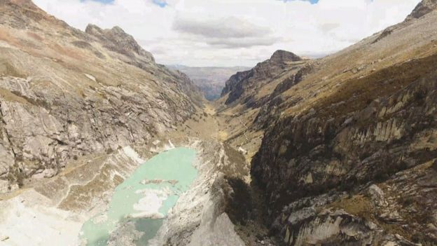
Edinburgh University doctoral student Rosie Bisset led the team that hiked high into the mountains of the Andes with her customized drones in order to get aerial images that would allow the team to create an accurate 3D model of the Llaca glacier.

“At that altitude the air is really thin, making it difficult to operate many drones,” she said.

“So we collaborated with a local company called Skytech Aerial to help us build a drone that would cope with the high altitude but also have the sensors we needed.”

As with many research projects, the team had to get creative to come up with the tools required. Edinburgh-based Skytech Aerial’s owner, Dr. David Redpath, provided the ingenuity and expertise that provided customized drones for the project.  Dr. Redpath told the BBC that he was able to customize the propellers need to spin faster in thinner air to create lift, running down the battery faster.  “We were able to merge ideas and customise one of the drones,” Redpath said.

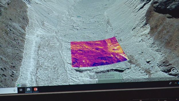
We contacted Redpath for more details on the mission – the hardware, software, and sensors.  “What Rosie specifically was looking for was a drone with a thermal camera underneath that would be able to do the thermal imaging of the glacier.  I happened to have a FLIR Vue 640R I could rent and she had a couple of DJI drones from other departments,” Redpath tells DRONELIFE.  “Because of cash and time limitations we decided to make a payload for the DJI Phantom Pro she had rather than build a custom drone. The DJI app ecosystem was very limiting as only UgCS allowed terrain following (to maintain even GSD of the surface) and we couldn’t get it to work even after paying the subscription fee.”

“In the end we selected Drone Deploy  risking the downloaded mission plan would work away from internet,” Redpath explains.

Reprinted with Permission

When it came to payload, the team faced more challenges – but an accident eventually led to a workable solution.

“I managed to engineer a mount for the bottom of the Phantom with the FLIR 640 on a fixed mount along with a geotagger and battery pack,” Redpath says. “However, I had many concerns over weight.”

“Sadly Rosie had a drone crash during practice, crashing into a field, luckily not with the FLIR,” said Redpath.

“I managed to source a new shell without a camera which turned out better in terms of weight. I managed to tap the internal battery to power the FLIR and geotagger to save a bit more weight.”

“All seemed to work well during local testing and I made an A4 ops manual for Rosie and her assistant to deal with any strange behavior: hot motor, battery warming, avoiding condors… and not falling down crevasses,” Redpath joked.

Rosie and her field assistant climbed two glaciers, each carrying a drone in a backpack, spending nights in sub-zero temps to get the images that they needed.  The researchers will use the images to build a 3D model of the Llaca glacier, and compare that model to images collected in previous years to see how the glacier is changing.

Thermal image of glacier

Image by Rosie Bisset


Harry McNabb
Harry McNabb

CEO DroneLife.com, DroneRacingLife.com, and CMO of Jobfordrones.com. Principle at Spalding Barker Strategies. Has enjoyed working with and around the commercial drone industry for the last 10 years.   Attendance and speaker at Industry Events such as Commercial UAV, InterGeo, Interdrone and others.   Proud father of two. Enjoys karate, Sherlock Holmes, and interesting things.  Subscribe to all things drone at DroneLife here. Email is Harry@dronelife.com.   Make Sure that you WhiteList us in your email to make sure you get our Newsletter.  Editor1@dronelife.com.

Filed Under: Applications, Conservation, Data analytics, Drone News, Drone News Feeds, Featured, Imaging, News, Products, Sensors, Thermal imaging Tagged With: Andes drone research, DJI, dji phantom pro, DroneDeploy, flir, flir vue, flir vue 640r, FLIR Vue Pro, global warming studies with Drones

Reader Interactions

Trackbacks

  1. An Insider Look at an Edinburgh University Researcher’s Drone Project in the Andes – the Drones, the Sensors, and the Software | Aerial Division says:
    March 16, 2020 at 10:50 pm

    […] post An Insider Look at an Edinburgh University Researcher’s Drone Project in the Andes – the… appeared first on […]

    Reply
  2. An Insider Take a look at an Edinburgh College Researcher's Drone Mission within the Andes - the Drones, the Sensors, and the Software program - Drone Stuff Pro says:
    March 11, 2020 at 6:06 pm

    […] Supply hyperlink […]

    Reply
  3. An Insider Look at an Edinburgh University Researcher's Drone Project in the Andes - the Drones, the Sensors, and the Software ⋆ says:
    March 11, 2020 at 5:26 pm

    […] The complete article is here […]

    Reply
  4. DRONELIFE Exclusive: An Insider Look at an Edinburgh University Researcher’s Drone Project in the Andes – the Drones, the Sensors, and the Software | Drone Magazine says:
    March 11, 2020 at 3:59 pm

    […] Source […]

    Reply
  5. DRONELIFE Exclusive: An Insider Look at an Edinburgh University Researcher’s Drone Project in the Andes – the Drones, the Sensors, and the Software | Gadgets says:
    March 11, 2020 at 3:53 pm

    […] Source link […]

    Reply

Leave a Reply Cancel reply

Your email address will not be published. Required fields are marked *

Primary Sidebar

LATEST

Titan Protection Receives FAA Approval for One-to-Many Drone Operations

Titan Protection has secured FAA approval to conduct one-to-many drone operations, enabling a single remote pilot to oversee up to…

Continue Reading Titan Protection Receives FAA Approval for One-to-Many Drone Operations

DroneOD Joins Space Park Leicester to Advance Cross-Platform Drone Technologies

DroneOD, a UK start-up developing universal connectivity solutions for unmanned aerial systems, has joined Space Park Leicester at its £100…

Continue Reading DroneOD Joins Space Park Leicester to Advance Cross-Platform Drone Technologies

Autoflight Unveils First 5-Ton Heavy Lift eVTOL Aircraft

AutoFlight has introduced Matrix, the world’s first 5-ton eVTOL aircraft, successfully completing a public full transition flight demonstration at its…

Continue Reading Autoflight Unveils First 5-Ton Heavy Lift eVTOL Aircraft

FAA Signals Tougher Stance on Unauthorized Drone Operations

Agency issues fines, license suspensions, and revocations for unsafe and unauthorized drone operations The Federal Aviation Administration (FAA) took enforcement…

Continue Reading FAA Signals Tougher Stance on Unauthorized Drone Operations

New DIU Project Targets Scalable, Containerized Drone Launch and Recovery Systems

DoD Seeks Automated Infrastructure to Support Large-Scale Autonomous Drone Operations The U.S. Department of Defense (DoD), through the Defense Innovation…

Continue Reading New DIU Project Targets Scalable, Containerized Drone Launch and Recovery Systems

The Companies Tapped for the Pentagon’s Drone Dominance Push

U.S. Department of War Launches Industry Competition for Drone Dominance Program Phase I The U.S. Department of War has formally…

Continue Reading The Companies Tapped for the Pentagon’s Drone Dominance Push

MatrixSpace Expands AI Software Platform to Enable Multi-Sensor, Real-Time Counter-Drone Detection

Updated edge-to-cloud architecture supports early warning, threat assessment, and unified airspace awareness MatrixSpace has announced a major update to its…

Continue Reading MatrixSpace Expands AI Software Platform to Enable Multi-Sensor, Real-Time Counter-Drone Detection

Why “Best-in-Class” Components Aren’t Enough Anymore

How sourcing expectations are changing how drones are engineered Amprius’ newly announced U.S.-based manufacturing partnership with Nanotech Energy is more…

Continue Reading Why “Best-in-Class” Components Aren’t Enough Anymore

SkyDrive to Demonstrate Remotely Piloted eVTOL Operations in Tokyo

Japan-based eVTOL developer SkyDrive Inc. will conduct demonstration flights of its Model SD-05 in Tokyo between February 24 and February…

Continue Reading SkyDrive to Demonstrate Remotely Piloted eVTOL Operations in Tokyo

Chemitek Solar Develops Drone-Compatible Cleaning Solution for Agrivoltaic Systems

Portuguese manufacturer Chemitek Solar has announced the development of its Drone AgroPV Cleaning Agent, a specialized biodegradable cleaning solution engineered…

Continue Reading Chemitek Solar Develops Drone-Compatible Cleaning Solution for Agrivoltaic Systems

Secondary Sidebar

Footer

SPONSORED

Inspired Flight Gremsy IF800 VIO F1 drones geo week

What Will It Take to Strengthen U.S. Drone Manufacturing? A Conversation with Inspired Flight’s CEO

Global Mapper Mobile data collection

Collection Ground Control Points with Global Mapper Mobile

Military Drone Mapping Solutions

How SimActive’s Correlator3D™ is Revolutionizing Military Mapping: An Exclusive Interview with CEO Philippe Simard

Photogrammetry Accuracy Standards

SimActive Photogrammetry Software: Enabling Users to Meet Accuracy Standards for Over 20 Years

NACT Engineering Parrot ANAFI tether indoor shot

Smart Tether for Parrot ANAFI USA from NACT Engineering

Blue Marble, features global mapper, features Blue Marble

Check Out These New Features in Global Mapper v25 from Blue Marble

About Us | Contact Us | Advertise With Us | Write for Us | Privacy Policy | Terms of Service

The Trusted Source for the Business of Drones.

This website uses cookies and third party services. By clicking OK, you are agreeing to our privacy policy. ACCEPT

Manage consent

Privacy Overview

This website uses cookies to improve your experience while you navigate through the website. Out of these, the cookies that are categorized as necessary are stored on your browser as they are essential for the working of basic functionalities of the website. We also use third-party cookies that help us analyze and understand how you use this website. These cookies will be stored in your browser only with your consent. You also have the option to opt-out of these cookies. But opting out of some of these cookies may affect your browsing experience.
Necessary
Always Enabled
Necessary cookies are absolutely essential for the website to function properly. These cookies ensure basic functionalities and security features of the website, anonymously.
CookieDurationDescription
cookielawinfo-checkbox-analytics11 monthsThis cookie is set by GDPR Cookie Consent plugin. The cookie is used to store the user consent for the cookies in the category "Analytics".
cookielawinfo-checkbox-functional11 monthsThe cookie is set by GDPR cookie consent to record the user consent for the cookies in the category "Functional".
cookielawinfo-checkbox-necessary11 monthsThis cookie is set by GDPR Cookie Consent plugin. The cookies is used to store the user consent for the cookies in the category "Necessary".
cookielawinfo-checkbox-others11 monthsThis cookie is set by GDPR Cookie Consent plugin. The cookie is used to store the user consent for the cookies in the category "Other.
cookielawinfo-checkbox-performance11 monthsThis cookie is set by GDPR Cookie Consent plugin. The cookie is used to store the user consent for the cookies in the category "Performance".
viewed_cookie_policy11 monthsThe cookie is set by the GDPR Cookie Consent plugin and is used to store whether or not user has consented to the use of cookies. It does not store any personal data.
Functional
Functional cookies help to perform certain functionalities like sharing the content of the website on social media platforms, collect feedbacks, and other third-party features.
Performance
Performance cookies are used to understand and analyze the key performance indexes of the website which helps in delivering a better user experience for the visitors.
Analytics
Analytical cookies are used to understand how visitors interact with the website. These cookies help provide information on metrics the number of visitors, bounce rate, traffic source, etc.
Advertisement
Advertisement cookies are used to provide visitors with relevant ads and marketing campaigns. These cookies track visitors across websites and collect information to provide customized ads.
Others
Other uncategorized cookies are those that are being analyzed and have not been classified into a category as yet.
SAVE & ACCEPT