• Skip to main content
  • Skip to secondary menu
  • Skip to primary sidebar
  • Skip to secondary sidebar
  • Skip to footer
  • DroneRacingLife
  • DroneFlyers
  • Newsletter
DroneLife

DRONELIFE

Stay up to date on all the latest Drone News

  • News
  • Products
  • Industries
    • Agriculture
    • Construction
    • Delivery
    • Dual Use
    • Inspection
    • Public Safety
    • Surveying
  • Enthusiasts
  • Regulations
  • Business
  • Video
  • Podcasts

Lessons from Hurricane Helene: How UAVs Supported Emergency Response in Western North Carolina

March 11, 2025 by Miriam McNabb Leave a Comment

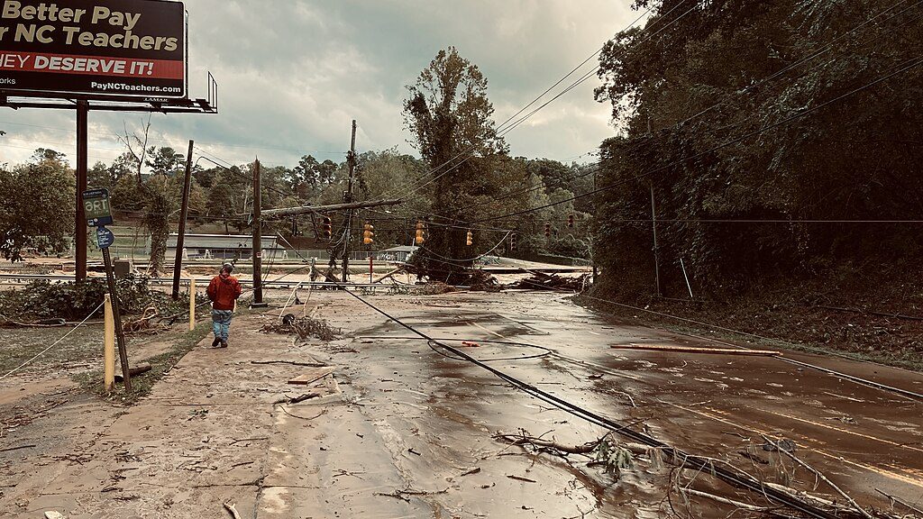
The response to Hurricane Helene demonstrated both the challenges and opportunities of using uncrewed aerial vehicles (UAVs) in disaster management. As a Category 4 hurricane, Helene caused massive devastation across Florida, Georgia, North Carolina, and other southeastern states, leaving more than 230 dead and causing an estimated $200 billion in damages. The storm’s record-breaking rainfall led to landslides, widespread flooding, and infrastructure failures, leaving many communities cut off from communication and critical resources.

Bill McMannis, CC BY 2.0 

At the National Public Safety UAS Conference hosted by DRONERESPONDERS, Captain Brandon Moore of the Asheville Police Department (APD) shared insights from their UAV operations during Hurricane Helene’s aftermath in Western North Carolina, highlighting both successes and critical lessons learned.

The Role of UAVs in Disaster Response

Despite having a patrol-based drone program, APD and its partners quickly realized the limitations of their connectivity infrastructure. With cellular and fiber connections down, radio systems failing, and SD cards becoming the only way to transfer data, UAV teams had to adapt rapidly.

The New Jersey Task Force 1 (NJ-TF1) was dispatched on September 25, followed by Asheville’s search and rescue (S&R) operations on September 27. APD’s UAV unit played a key role in:

  • Aerial overwatch and advanced search operations
  • Surveying impacted areas and documenting damages
  • Coordinating missions across agencies using flight planning tools

The teams faced significant challenges. The loss of city water infrastructure, impassable roadways, and repeated surveying requests from various agencies, including the Army Corps of Engineers, meant UAV teams needed to return to the same sites multiple times. The sheer volume of data required careful coordination to ensure that all imagery and insights were effectively shared with emergency management teams.

Critical Lessons and the Role of Industry Support

One of the biggest lessons learned was the need for robust connectivity solutions. UAV teams found that without Starlink systems or alternative satellite communication tools, real-time data sharing was nearly impossible. The experience reinforced the importance of a well-trained, proficient UAV program that anticipates the demands of large-scale disasters.

Another key takeaway was the importance of collaboration between public safety agencies and industry partners. More than 850 drone flights were conducted by 13 UAV teams from four states, with major contributions from vendors and volunteers who showed up to help without expecting payment.

Companies like Skydio arrived on-site, installed Starlink systems, and offered their support without compensation. Other industry leaders, including DJI, Autel, Axon Air, and Avionix contributed equipment, software, and expertise to keep operations running. Paladin provided remote drone flight support from Houston for three days, showcasing the potential for long-distance UAV coordination. Dronesense provided one of the most critical capabilities of UAVs during the response: the ability to aggregate and visualize multiple live drone feeds at once, providing emergency management teams with a comprehensive real-time view of the crisis.

Future Considerations for UAV Disaster Response

The experience of Hurricane Helene reinforced the critical role of UAVs in emergency management. However, agencies need to be sure that they are preparing in advance for the significant challenges that disasters pose.

  • Reliable connectivity: Ensuring UAV teams have satellite communication options like Starlink to maintain real-time data transfer.
  • Proactive coordination: Establishing clear agreements with industry partners and volunteer groups ahead of time to streamline disaster response.
  • Cross-agency budgeting: Exploring creative funding solutions that allow police, fire departments, city departments and emergency management teams to share drone program resources.
  • Advanced UAV training: Expanding UAV operator training in disaster response scenarios, particularly in search and rescue operations.

With continued investment in UAV technology and operational planning, future disaster response efforts can be even more effective, ensuring that communities receive faster, better-coordinated relief in the wake of major storms.

Want DRONELIFE news delivered to your inbox every weekday?  Sign up here.

Read more:

  • Drone Technology Aids Hurricane Helene Recovery in North Carolina
  • Unity in Crisis: How Drone Teams Mobilized to Aid Hurricane Helene Disaster Relief in Eastern Tennessee
  • Drones Aid Disaster Recovery: Mapping and Photogrammetry Support Hurricane Helene Relief Efforts


Miriam McNabb

Miriam McNabb is the Editor-in-Chief of DRONELIFE and CEO of JobForDrones, a professional drone services marketplace, and a fascinated observer of the emerging drone industry and the regulatory environment for drones. Miriam has penned over 3,000 articles focused on the commercial drone space and is an international speaker and recognized figure in the industry.  Miriam has a degree from the University of Chicago and over 20 years of experience in high tech sales and marketing for new technologies.
For drone industry consulting or writing, Email Miriam.

TWITTER:@spaldingbarker

Subscribe to DroneLife here.

Filed Under: Applications, Drone News, Drone News Feeds, Drones in the News, News Tagged With: aerial survey hurricane response, drone emergency management, drone industry collaboration, drone technology in disasters, Hurricane Helene drones, Public Safety Drones, Skydio disaster relief, UAV connectivity solutions, UAV disaster response, UAV search and rescue

Reader Interactions

Leave a Reply Cancel reply

Your email address will not be published. Required fields are marked *

Primary Sidebar

LATEST

NPSA Launches 2026 Counter-UAS Equipment Evaluations for UK Manufacturers

The National Protective Security Authority (NPSA) has opened expressions of interest for manufacturers and suppliers to participate in its independent…

Continue Reading NPSA Launches 2026 Counter-UAS Equipment Evaluations for UK Manufacturers

ISight Drone Services Achieves Statewide BVLOS Authorization for Vantis System in North Dakota

ISight Drone Services has received FAA approval to conduct beyond-visual-line-of-sight (BVLOS) operations across all four operational volumes of Vantis, North…

Continue Reading ISight Drone Services Achieves Statewide BVLOS Authorization for Vantis System in North Dakota

Unifly Completes FAA-Led Detect-and-Avoid Safety Standards Project

Terra Drone’s subsidiary Unifly has completed validation of “Well Clear Requirements” for drone Detect-and-Avoid (DAA) systems under the FAA’s ASSURE…

Continue Reading Unifly Completes FAA-Led Detect-and-Avoid Safety Standards Project

Meteodrones Provide New Data to National Weather Service

Switzerland-based meteorology data company Meteomatics has announced a partnership with NOAA’s National Mesonet Program (NMP) to integrate operational weather drone…

Continue Reading Meteodrones Provide New Data to National Weather Service

AURA Network Systems Conducts BVLOS Communications Tests

In collaboration with the Northern Plains UAS Test Site (NPUASTS) and the Federal Aviation Administration (FAA), AURA Network Systems has…

Continue Reading AURA Network Systems Conducts BVLOS Communications Tests

JIATF Awards First Replicator 2 Contract for C-UAS System

The Joint Interagency Task Force 401 (JIATF 401) has awarded its first contract under the Replicator 2 initiative, procuring two…

Continue Reading JIATF Awards First Replicator 2 Contract for C-UAS System

FAA Adds Two New UAS Test Sites to Advance Drone Integration

The U.S. Department of Transportation and the Federal Aviation Administration have announced two new UAS Test Sites in partnership with…

Continue Reading FAA Adds Two New UAS Test Sites to Advance Drone Integration

Kansas, Missouri Funding Counter-UAS at World Cup Events

By Dronelife Features Editor Jim Magill (Editor’s note: This is the second in a series of stories on efforts to…

Continue Reading Kansas, Missouri Funding Counter-UAS at World Cup Events

Electric UAS Demonstrates Relay-Extended Connectivity and Tactical Cross-Country Flights

Kraus Hamdani Aerospace (KHA) has completed a series of cross-country electric unmanned operations at Pendleton UAS Range (PUR) using its…

Continue Reading Electric UAS Demonstrates Relay-Extended Connectivity and Tactical Cross-Country Flights

Hirth Engines, ePropelled Partner For Hybrid UAV Power Systems

Hirth Engines and ePropelled announced a strategic collaboration to develop hybrid propulsion solutions targeting the UAV, aerospace, and defence markets.…

Continue Reading Hirth Engines, ePropelled Partner For Hybrid UAV Power Systems

Secondary Sidebar

Footer

SPONSORED

Inspired Flight Gremsy IF800 VIO F1 drones geo week

What Will It Take to Strengthen U.S. Drone Manufacturing? A Conversation with Inspired Flight’s CEO

Global Mapper Mobile data collection

Collection Ground Control Points with Global Mapper Mobile

Military Drone Mapping Solutions

How SimActive’s Correlator3D™ is Revolutionizing Military Mapping: An Exclusive Interview with CEO Philippe Simard

Photogrammetry Accuracy Standards

SimActive Photogrammetry Software: Enabling Users to Meet Accuracy Standards for Over 20 Years

NACT Engineering Parrot ANAFI tether indoor shot

Smart Tether for Parrot ANAFI USA from NACT Engineering

Blue Marble, features global mapper, features Blue Marble

Check Out These New Features in Global Mapper v25 from Blue Marble

About Us | Contact Us | Advertise With Us | Write for Us | Privacy Policy | Terms of Service

The Trusted Source for the Business of Drones.

This website uses cookies and third party services. By clicking OK, you are agreeing to our privacy policy. ACCEPT

Manage consent

Privacy Overview

This website uses cookies to improve your experience while you navigate through the website. Out of these, the cookies that are categorized as necessary are stored on your browser as they are essential for the working of basic functionalities of the website. We also use third-party cookies that help us analyze and understand how you use this website. These cookies will be stored in your browser only with your consent. You also have the option to opt-out of these cookies. But opting out of some of these cookies may affect your browsing experience.
Necessary
Always Enabled
Necessary cookies are absolutely essential for the website to function properly. These cookies ensure basic functionalities and security features of the website, anonymously.
CookieDurationDescription
cookielawinfo-checkbox-analytics11 monthsThis cookie is set by GDPR Cookie Consent plugin. The cookie is used to store the user consent for the cookies in the category "Analytics".
cookielawinfo-checkbox-functional11 monthsThe cookie is set by GDPR cookie consent to record the user consent for the cookies in the category "Functional".
cookielawinfo-checkbox-necessary11 monthsThis cookie is set by GDPR Cookie Consent plugin. The cookies is used to store the user consent for the cookies in the category "Necessary".
cookielawinfo-checkbox-others11 monthsThis cookie is set by GDPR Cookie Consent plugin. The cookie is used to store the user consent for the cookies in the category "Other.
cookielawinfo-checkbox-performance11 monthsThis cookie is set by GDPR Cookie Consent plugin. The cookie is used to store the user consent for the cookies in the category "Performance".
viewed_cookie_policy11 monthsThe cookie is set by the GDPR Cookie Consent plugin and is used to store whether or not user has consented to the use of cookies. It does not store any personal data.
Functional
Functional cookies help to perform certain functionalities like sharing the content of the website on social media platforms, collect feedbacks, and other third-party features.
Performance
Performance cookies are used to understand and analyze the key performance indexes of the website which helps in delivering a better user experience for the visitors.
Analytics
Analytical cookies are used to understand how visitors interact with the website. These cookies help provide information on metrics the number of visitors, bounce rate, traffic source, etc.
Advertisement
Advertisement cookies are used to provide visitors with relevant ads and marketing campaigns. These cookies track visitors across websites and collect information to provide customized ads.
Others
Other uncategorized cookies are those that are being analyzed and have not been classified into a category as yet.
SAVE & ACCEPT