• Skip to main content
  • Skip to secondary menu
  • Skip to primary sidebar
  • Skip to secondary sidebar
  • Skip to footer
  • DroneRacingLife
  • DroneFlyers
  • Newsletter
DroneLife

DRONELIFE

Stay up to date on all the latest Drone News

  • News
  • Products
  • Industries
    • Agriculture
    • Construction
    • Delivery
    • Dual Use
    • Inspection
    • Public Safety
    • Surveying
  • Enthusiasts
  • Regulations
  • Business
  • Video
  • Podcasts

The Best Pairing for Wine May be a Drone

March 6, 2020 by Miriam McNabb 4 Comments

License: cc0

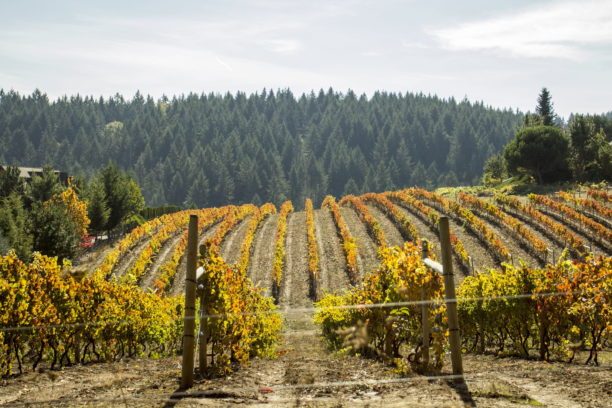
With a wide and global customer base, drone mapping platform DroneDeploy is continually identifying new uses for drone technology.  Precision agriculture was one of the early adopters of drone technology: and now, more vineyards are adopting drones to make better wine.

It’s not the romantic view of the wine industry pictured on travel brochures, but drones are helping growers to identify and flag  diseased plants before they are able to spread and infect the rest of the crop.

Using drones to gather data is a huge time saver – what could take workers a week walking up and down the rows takes a drone only minutes to achieve with 95% accuracy.  Gathering the data quickly also ensures that diseases are dealt with quickly – and that’s an enormous savings for the industry.  While there are many diseases that commonly attack wine grapes, research published in California Agriculture says that just one of these – Pierce’s disease – costs California growers over $100 million a year: a few years ago, Wine Spectator called the spread of vine disease “A Dire Threat to Grapevines and Wine.”

Viticulture, and agriculture in general, can be a challenging business, requiring expert analysis to meet challenges like disease. “In agriculture broadly, we’re seeing greatest adoption from service providers – from agronomists who go on site to provide information to growers,” says DroneDeploy co-founder and CEO, Mike Winn.  “And they’re starting that whole process with a drone.”  Winn explains that agronomists will start a consultation by flying over the fields and using DroneDeploy’s LiveMap product to get an instant aerial view of the area.

“The key component of this is efficiency,” says Winn.  “People are busy – there is always time pressure. Speed is of critical importance: not just how long it takes to get the data, but how long it takes to process and use it.”  LiveMap has been a game changer.  Instead of traditional full processing, which is extremely detailed but can take time, LiveMap processes as you fly.  “This is a product we’ve been building for almost three years,” says Winn.  “We can build a map and update literally every second.  It’s the fastest way to get an idea of what’s going on on the ground – to see immediately what’s going on.”

Growers are looking for variances in color that could indicate an issue.  “Customers can spot variances immediately,” says Winn, “and some of them start walking out to the affected area while the drone is still in the air.”  Winn says that the majority of agricultural data that DroneDeploy processes is through LiveMap, which has progressed to the point that it can be hard to distinguish between LiveMap and fully processed data.

“We’re able to leverage continued advancements in mobile technology and computer vision,” says Winn. “That’s enabling LiveMap to become a really powerful.”  In addition to instant processing, the company introduced two more new features in January which are helping agronomists to be even more effective.  Terrain following automatically adjusts the altitude of the drone to follow the terrain: which makes the flight safer and the data more accurate.    DroneDeploy also partnered with drone manufacturer DJI and sensor experts MicaSense to introduce multispectral processing capability. “That’s really important to the research communities in agriculture,” says Winn. “Multispectral allows you to capture scientifically calibrated data and from that we can pull out detailed insights that allow you to detect health problems more easily.”

In all areas of agriculture, including viticulture, drones are becoming a standard part of the agronomist’s toolkit.  One reason is that drone data has become so much easier to access; another is simply a question of exposure. “We’re seeing adoption of the technology create more adoption,” says Winn.  “We’re now seeing very large deployments of drones – our biggest agricultural customer has over 1,000 pilots.  That’s exposing more and more people to drone data, and that’s creating more demand.”

“Agriculture has always been thought of as a big opportunity for drones – but now we are seeing drones used by the largest agriculture companies.  That’s because drones have become very efficient and cost effective tools,” Winn says.

Miriam McNabb

Miriam McNabb is the Editor-in-Chief of DRONELIFE and CEO of JobForDrones, a professional drone services marketplace, and a fascinated observer of the emerging drone industry and the regulatory environment for drones. Miriam has penned over 3,000 articles focused on the commercial drone space and is an international speaker and recognized figure in the industry.  Miriam has a degree from the University of Chicago and over 20 years of experience in high tech sales and marketing for new technologies.
For drone industry consulting or writing, Email Miriam.

TWITTER:@spaldingbarker

Subscribe to DroneLife here.

Filed Under: Drone News Feeds, Featured, Featured - Agriculture, News Tagged With: drone mapping, DroneDeploy, drones and wine, drones in agriculture, Precision Agriculture

Reader Interactions

Trackbacks

  1. The Best Pairing for Wine May be a Drone – Best Drone Company says:
    March 7, 2020 at 12:32 pm

    […] Source link […]

    Reply
  2. The Best Pairing for Wine May be a Drone | Drone Magazine says:
    March 6, 2020 at 5:01 pm

    […] Source […]

    Reply
  3. The Best Pairing for Wine May be a Drone - taktik(z) Staging says:
    March 6, 2020 at 4:27 pm

    […] Source: DroneLife […]

    Reply
  4. The Best Pairing for Wine May be a Drone | Gadgets says:
    March 6, 2020 at 4:25 pm

    […] Source link […]

    Reply

Leave a Reply Cancel reply

Your email address will not be published. Required fields are marked *

Primary Sidebar

LATEST

Blue Innovation Deploys Drones for Nighttime Wildfire Imaging in Japan

This article published in collaboration with JUIDA, the Japan UAS Industrial Development Association.     Blue Innovation Co., Ltd. deployed drones…

Continue Reading Blue Innovation Deploys Drones for Nighttime Wildfire Imaging in Japan

University of Kentucky Researcher Wins NSF Award for Drone Fleet Safety Research

A University of Kentucky researcher has received a National Science Foundation (NSF) CAREER Award worth $534,264 over five years to develop safer…

Continue Reading University of Kentucky Researcher Wins NSF Award for Drone Fleet Safety Research

Canada Bets Big on Sovereign Drone Power with New National Innovation Hub

Canada to establish Drone Innovation Hub By DRONELIFE Features Editor Jim Magill Canada, which has become a world leader in…

Continue Reading Canada Bets Big on Sovereign Drone Power with New National Innovation Hub

Drones Support World-First Mouse Eradication Project on Remote Australian Island

Aerial baiting effort aims to restore seabird populations and fragile ecosystems A remote island off the coast of Western Australia…

Continue Reading Drones Support World-First Mouse Eradication Project on Remote Australian Island

Who Gets to Fly? ACLU Paper Examines the Future of Drone Access

Access, Regulation, and the Future of Drone Use Analysis raises questions about how policy decisions may shape who benefits from…

Continue Reading Who Gets to Fly? ACLU Paper Examines the Future of Drone Access

New DJI Avata 360 Brings 8K 360-Degree FPV Flying to Creators

DJI today launched the DJI Avata 360, a new 8K 360-degree FPV drone built for immersive aerial content creation. The…

Continue Reading New DJI Avata 360 Brings 8K 360-Degree FPV Flying to Creators

Michigan Pushes Sweeping Drone Legislation Package Through State Legislature

By Dronelife Features Editor Jim Magill An extensive package of drone-related legislation, ranging from bills that would restrict the use…

Continue Reading Michigan Pushes Sweeping Drone Legislation Package Through State Legislature

AirData Launches 3D Flight Player for Advanced Drone Flight Review

New tool converts flight logs into interactive 3D visualizations for training and analysis AirData has introduced a new tool designed…

Continue Reading AirData Launches 3D Flight Player for Advanced Drone Flight Review

Lucid Bots Raises $20M to Scale Autonomous Exterior Cleaning Drone Platform

Funding supports expansion of robotics, AI, and subscription-based service model for cleaning operators Lucid Bots has raised $20 million in…

Continue Reading Lucid Bots Raises $20M to Scale Autonomous Exterior Cleaning Drone Platform

Drones Transform Warehouse Operations at Southern Glazer’s

Corvus Robotics rollout supports supply chain transformation and improved warehouse performance Southern Glazer’s Wine & Spirits has expanded its use…

Continue Reading Drones Transform Warehouse Operations at Southern Glazer’s

Secondary Sidebar

Footer

SPONSORED

Inspired Flight Gremsy IF800 VIO F1 drones geo week

What Will It Take to Strengthen U.S. Drone Manufacturing? A Conversation with Inspired Flight’s CEO

Global Mapper Mobile data collection

Collection Ground Control Points with Global Mapper Mobile

Military Drone Mapping Solutions

How SimActive’s Correlator3D™ is Revolutionizing Military Mapping: An Exclusive Interview with CEO Philippe Simard

Photogrammetry Accuracy Standards

SimActive Photogrammetry Software: Enabling Users to Meet Accuracy Standards for Over 20 Years

NACT Engineering Parrot ANAFI tether indoor shot

Smart Tether for Parrot ANAFI USA from NACT Engineering

Blue Marble, features global mapper, features Blue Marble

Check Out These New Features in Global Mapper v25 from Blue Marble

About Us | Contact Us | Advertise With Us | Write for Us | Privacy Policy | Terms of Service

The Trusted Source for the Business of Drones.

This website uses cookies and third party services. By clicking OK, you are agreeing to our privacy policy. ACCEPT

Manage consent

Privacy Overview

This website uses cookies to improve your experience while you navigate through the website. Out of these, the cookies that are categorized as necessary are stored on your browser as they are essential for the working of basic functionalities of the website. We also use third-party cookies that help us analyze and understand how you use this website. These cookies will be stored in your browser only with your consent. You also have the option to opt-out of these cookies. But opting out of some of these cookies may affect your browsing experience.
Necessary
Always Enabled
Necessary cookies are absolutely essential for the website to function properly. These cookies ensure basic functionalities and security features of the website, anonymously.
CookieDurationDescription
cookielawinfo-checkbox-analytics11 monthsThis cookie is set by GDPR Cookie Consent plugin. The cookie is used to store the user consent for the cookies in the category "Analytics".
cookielawinfo-checkbox-functional11 monthsThe cookie is set by GDPR cookie consent to record the user consent for the cookies in the category "Functional".
cookielawinfo-checkbox-necessary11 monthsThis cookie is set by GDPR Cookie Consent plugin. The cookies is used to store the user consent for the cookies in the category "Necessary".
cookielawinfo-checkbox-others11 monthsThis cookie is set by GDPR Cookie Consent plugin. The cookie is used to store the user consent for the cookies in the category "Other.
cookielawinfo-checkbox-performance11 monthsThis cookie is set by GDPR Cookie Consent plugin. The cookie is used to store the user consent for the cookies in the category "Performance".
viewed_cookie_policy11 monthsThe cookie is set by the GDPR Cookie Consent plugin and is used to store whether or not user has consented to the use of cookies. It does not store any personal data.
Functional
Functional cookies help to perform certain functionalities like sharing the content of the website on social media platforms, collect feedbacks, and other third-party features.
Performance
Performance cookies are used to understand and analyze the key performance indexes of the website which helps in delivering a better user experience for the visitors.
Analytics
Analytical cookies are used to understand how visitors interact with the website. These cookies help provide information on metrics the number of visitors, bounce rate, traffic source, etc.
Advertisement
Advertisement cookies are used to provide visitors with relevant ads and marketing campaigns. These cookies track visitors across websites and collect information to provide customized ads.
Others
Other uncategorized cookies are those that are being analyzed and have not been classified into a category as yet.
SAVE & ACCEPT