• Skip to main content
  • Skip to secondary menu
  • Skip to primary sidebar
  • Skip to secondary sidebar
  • Skip to footer
  • DroneRacingLife
  • DroneFlyers
  • Newsletter
DroneLife

DRONELIFE

Stay up to date on all the latest Drone News

  • News
  • Products
  • Industries
    • Agriculture
    • Construction
    • Delivery
    • Dual Use
    • Inspection
    • Public Safety
    • Surveying
  • Enthusiasts
  • Regulations
  • Business
  • Video
  • Podcasts

Kittyhawk and the FAA Introduce the New Version of B4UFLY, Free App for Drone Operators

July 31, 2019 by Miriam McNabb 5 Comments

It’s a complex problem: how to ensure that all drone operators have up-to-date information on airspace before they fly.  It isn’t just a question of publishing NOTAMS and maps: drone flyers are a diverse group, ranging from professioal pilots to kids exploring the airspace for the first time.  The information has to be readily available, easy to use, up-to-date – and free.

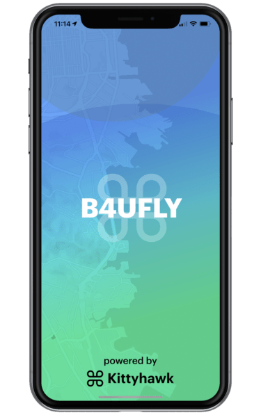
So when the FAA partnered with drone software leaders Kittyhawk to update B4UFLY, the FAA’s free app, it was great news.  Better and easier to use airspace information means better access for all flyers – and fewer mistakes that damage the public perception of drones.  Today, Kittyhawk and the FAA announced the new version is available.

The following is a joint press release from Kittyhawk and the FAA.

SAN FRANCISCO AND WASHINGTON ​- July 31, 2019 -​ ​Kittyhawk​ the market leader in drone software and the U.S. Department of Transportation’s Federal Aviation Administration (FAA) today introduced a new version of B4UFLY, the free mobile app that lets drone operators check the status of airspace prior to flight. Available now for iOS and Android, the app determines what airspace restrictions are in effect at any location in the United States, in real-time.

B4UFLY is a key tool in the safe integration of unmanned aircraft systems (UAS) into the National Airspace System (NAS) that empowers recreational, commercial, and government drone operators with the situational awareness to fly safely and responsibly every time. More than 700,000 people have used B4UFLY since its original launch in 2016. B4UFLY is provided through a partnership between the FAA and Kittyhawk at no cost to taxpayers.

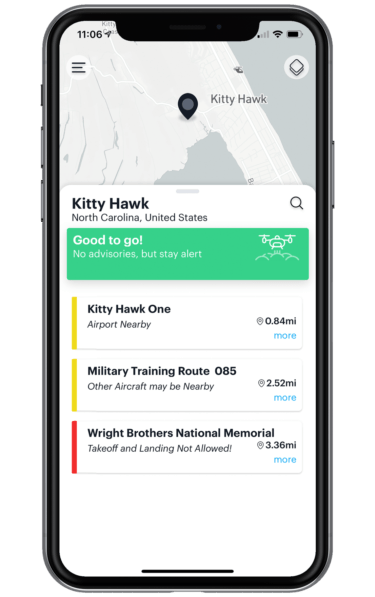
The new app leverages Dynamic Airspace, Kittyhawk’s patented airspace controller for managing real-time flight restrictions, authorizations, and guidance. B4UFLY programmatically consumes FAA data sources for controlled airspace, special use airspace, critical infrastructure, airports, national parks, military training routes, and temporary flight restrictions.

Based on location, B4UFLY provides simple, easy to understand airspace guidance that includes Good to Go, Warning and Do Not Fly. The app also provides links to helpful UAS educational content, safety resources, and LAANC, the FAA’s Low Altitude Authorization and Notification Capability for obtaining authorizations to fly in controlled airspace.

“B4UFLY is a hallmark of our commitment to ensuring drones are safely integrated into the NAS. Our partnership on B4UFLY with Kittyhawk represents the kind of public-private partnership that is essential to advance this burgeoning industry. As the skies become more crowded and UAS operations become more complex, basic airspace situational awareness, especially for the newest of fliers, will be essential,” said Jay Merkle, Executive Director, FAA UAS Integration Office.

“Kittyhawk was the birthplace of manned aviation and we’re proud to continue that legacy of innovation with the new B4UFLY app,” said Jon Hegranes, Kittyhawk CEO and Founder. “While the Wright brothers had a vast and soft landing area, drone pilots face sometimes complex rules and restrictions that can change quickly. Our goal with B4UFLY is to make knowing when and how you should fly simple, quick, and reliable.”

Future development of B4UFLY will include new capabilities for weather, Remote ID and additional data layers for uses in public safety, natural disasters and emergency response.

About Kittyhawk

Kittyhawk unifies the mission, aircraft and data to empower safe and effective drone operations. Based in San Francisco, the company develops full stack enterprise drone solutions for professional pilots and fleet managers in energy, insurance, media, transportation, and public safety. Founded in 2015, the company has received $9.5 million in aggregate funding from Travelers, Bonfire Ventures, Boeing HorizonX Ventures, Freestyle Ventures, and The Flying Object (TFO). Learn more at​ https://kittyhawk.io​.

About B4UFLY

B4UFLY is the simple, easy-to-understand way for drone operators to check airspace before taking flight. Stay compliant, and contribute to a safer national airspace by making yourself aware of advisories and restrictions in the airspace around you. With B4UFLY, you simply open the app and select where you want to fly to see the status of the airspace selected, as well as details regarding surrounding advisories. B4UFLY is provided through a partnership between the FAA and Kittyhawk IO. Visit ​https://kittyhawk.io/b4ufly/​ to download the app and learn more.

Miriam McNabb

Miriam McNabb is the Editor-in-Chief of DRONELIFE and CEO of JobForDrones, a professional drone services marketplace, and a fascinated observer of the emerging drone industry and the regulatory environment for drones. Miriam has penned over 3,000 articles focused on the commercial drone space and is an international speaker and recognized figure in the industry.  Miriam has a degree from the University of Chicago and over 20 years of experience in high tech sales and marketing for new technologies.
For drone industry consulting or writing, Email Miriam.

TWITTER:@spaldingbarker

Subscribe to DroneLife here.

Filed Under: Drone News Feeds, Featured - FAA and Regulations, Legal, News Tagged With: B4UFLY, b4ufly app, FAA, Kittyhawk

Reader Interactions

Trackbacks

  1. Kittyhawk Changes Its Name but Not Its Mission: Introducing Aloft Technologies Inc. - The Drone Page says:
    June 3, 2021 at 8:18 am

    […] formed a partnership with the FAA in 2019, reworking the B4UFly app in a public private partnership that benefited the drone community.  But as Kittyhawk changes its […]

    Reply
  2. Kittyhawk and the FAA Introduce the New Version of B4UFLY, Free App for Drone Operators – DroneLife says:
    August 1, 2019 at 12:12 pm

    […] Kittyhawk and the FAA Introduce the New Version of B4UFLY, Free App for Drone Operators  DroneLife […]

    Reply
  3. Kittyhawk and the FAA Introduce the New Version of B4UFLY, Free App for Drone Operators | MyDroneWorld says:
    July 31, 2019 at 9:08 pm

    […] Source link […]

    Reply
  4. Kittyhawk and the FAA Introduce the New Version of B4UFLY, Free App for Drone Operators - Drones Crunch says:
    July 31, 2019 at 8:34 pm

    […] DRONELIFE […]

    Reply
  5. Kittyhawk and the FAA Introduce the New Version of B4UFLY, Free App for Drone Operators | Drone Magazine says:
    July 31, 2019 at 4:52 pm

    […] Source […]

    Reply

Leave a Reply Cancel reply

Your email address will not be published. Required fields are marked *

Primary Sidebar

LATEST

Rogue Drone Detected. Now What?

SkySafe and Motorola Solutions integration highlights the next step in managing low-altitude airspace At the Motorola Solutions Summit 2026 this…

Continue Reading Rogue Drone Detected. Now What?

New DJI Drones Launch Globally, But Not in the U.S.

Court filing highlights FCC restrictions as new products debut without U.S. availability Drone giant DJI has introduced new consumer drones,…

Continue Reading New DJI Drones Launch Globally, But Not in the U.S.

NYC Tests Cargo Drones to Cut Traffic and Speed Medical Deliveries

Port Authority Launches Yearlong Cargo Drone Trial Over East River. Skyports partnership aims to test middle-mile delivery, reduce congestion, and…

Continue Reading NYC Tests Cargo Drones to Cut Traffic and Speed Medical Deliveries

AirData and BRINC Integration Brings Automated Flight Records to Public Safety Drone Programs

New integration captures flight data automatically, supporting scalable and auditable drone operations AirData has announced a new integration with BRINC,…

Continue Reading AirData and BRINC Integration Brings Automated Flight Records to Public Safety Drone Programs

Sentrycs Lands Major Counter-Drone Contracts Across World Cup Cities

Sentrycs systems to protect skies in U.S., Mexico, Canada By DRONELIFE Features Editor Jim Magill (Editor’s note: This is part…

Continue Reading Sentrycs Lands Major Counter-Drone Contracts Across World Cup Cities

Kraus Hamdani Aerospace Demonstrates Wireless Power Beaming to K1000ULE at Shaw AFB

Kraus Hamdani Aerospace and PowerLight Technologies sustain the K1000ULE in flight using laser-based wireless power beaming, maintaining continuous ISR operations…

Continue Reading Kraus Hamdani Aerospace Demonstrates Wireless Power Beaming to K1000ULE at Shaw AFB

Sion Power Launches Two High Energy Density Batteries for Military Drones

Sion Power’s Licerion Strike and Echo cells exceed 500 Wh/kg, enabling combat drones to fly two to three times longer…

Continue Reading Sion Power Launches Two High Energy Density Batteries for Military Drones

UNOS and NASA Partner to Study Drone Organ Transport

UNOS and NASA launch a joint study to examine how UAV flights affect organ viability and how drones could improve…

Continue Reading UNOS and NASA Partner to Study Drone Organ Transport

A Day in the Life in Ouachita Parish: Inside a Real-Time Crime Center Where Drones Shape the Response

From first call to final decision, how aerial intelligence is helping Ouachita Parish deputies arrive informed, and safer. A System…

Continue Reading A Day in the Life in Ouachita Parish: Inside a Real-Time Crime Center Where Drones Shape the Response

Amusement Parks Push FAA for Drone Flight Restrictions Before Summer

Amusement parks push for FAA drone flight restrictions to protect summer crowds from unauthorized UAV overflights this season. By Dronelife…

Continue Reading Amusement Parks Push FAA for Drone Flight Restrictions Before Summer

Secondary Sidebar

Footer

SPONSORED

Inspired Flight Gremsy IF800 VIO F1 drones geo week

What Will It Take to Strengthen U.S. Drone Manufacturing? A Conversation with Inspired Flight’s CEO

Global Mapper Mobile data collection

Collection Ground Control Points with Global Mapper Mobile

Military Drone Mapping Solutions

How SimActive’s Correlator3D™ is Revolutionizing Military Mapping: An Exclusive Interview with CEO Philippe Simard

Photogrammetry Accuracy Standards

SimActive Photogrammetry Software: Enabling Users to Meet Accuracy Standards for Over 20 Years

NACT Engineering Parrot ANAFI tether indoor shot

Smart Tether for Parrot ANAFI USA from NACT Engineering

Blue Marble, features global mapper, features Blue Marble

Check Out These New Features in Global Mapper v25 from Blue Marble

About Us | Contact Us | Advertise With Us | Write for Us | Privacy Policy | Terms of Service

The Trusted Source for the Business of Drones.

This website uses cookies and third party services. By clicking OK, you are agreeing to our privacy policy. ACCEPT

Manage consent

Privacy Overview

This website uses cookies to improve your experience while you navigate through the website. Out of these, the cookies that are categorized as necessary are stored on your browser as they are essential for the working of basic functionalities of the website. We also use third-party cookies that help us analyze and understand how you use this website. These cookies will be stored in your browser only with your consent. You also have the option to opt-out of these cookies. But opting out of some of these cookies may affect your browsing experience.
Necessary
Always Enabled
Necessary cookies are absolutely essential for the website to function properly. These cookies ensure basic functionalities and security features of the website, anonymously.
CookieDurationDescription
cookielawinfo-checkbox-analytics11 monthsThis cookie is set by GDPR Cookie Consent plugin. The cookie is used to store the user consent for the cookies in the category "Analytics".
cookielawinfo-checkbox-functional11 monthsThe cookie is set by GDPR cookie consent to record the user consent for the cookies in the category "Functional".
cookielawinfo-checkbox-necessary11 monthsThis cookie is set by GDPR Cookie Consent plugin. The cookies is used to store the user consent for the cookies in the category "Necessary".
cookielawinfo-checkbox-others11 monthsThis cookie is set by GDPR Cookie Consent plugin. The cookie is used to store the user consent for the cookies in the category "Other.
cookielawinfo-checkbox-performance11 monthsThis cookie is set by GDPR Cookie Consent plugin. The cookie is used to store the user consent for the cookies in the category "Performance".
viewed_cookie_policy11 monthsThe cookie is set by the GDPR Cookie Consent plugin and is used to store whether or not user has consented to the use of cookies. It does not store any personal data.
Functional
Functional cookies help to perform certain functionalities like sharing the content of the website on social media platforms, collect feedbacks, and other third-party features.
Performance
Performance cookies are used to understand and analyze the key performance indexes of the website which helps in delivering a better user experience for the visitors.
Analytics
Analytical cookies are used to understand how visitors interact with the website. These cookies help provide information on metrics the number of visitors, bounce rate, traffic source, etc.
Advertisement
Advertisement cookies are used to provide visitors with relevant ads and marketing campaigns. These cookies track visitors across websites and collect information to provide customized ads.
Others
Other uncategorized cookies are those that are being analyzed and have not been classified into a category as yet.
SAVE & ACCEPT