• Skip to main content
  • Skip to secondary menu
  • Skip to primary sidebar
  • Skip to secondary sidebar
  • Skip to footer
  • DroneRacingLife
  • DroneFlyers
  • Newsletter
DroneLife

DRONELIFE

Stay up to date on all the latest Drone News

  • News
  • Products
  • Industries
    • Agriculture
    • Construction
    • Delivery
    • Dual Use
    • Inspection
    • Public Safety
    • Surveying
  • Enthusiasts
  • Regulations
  • Business
  • Video
  • Podcasts

This is Cool: Echodyne Demonstrates Augmented Reality for Airspace Awareness

May 2, 2019 by Miriam McNabb 11 Comments

Echodyne Hololens
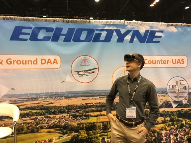
This is one of the coolest things we got to experience at this year’s AUVSI Xponential: finding a drone in the sky through Hololens augmented reality glasses.

Here it is: imagine that you’ve secured an area of airspace around your drone operation.  The Echodyne system has identified a drone in the airspace.  Now, you need to find it in the sky – and learn all there is to know about the aircraft, identifying it as friend or foe.

With this reference architecture displayed by Echodyne, you just turn your head.  Wearing the Hololens augmented reality headset, you follow the arrows in your field of vision until you find the drone in the sky – then twitch your fingers and see all of the data the system holds on that aircraft.  It’s a stunning demonstration of the possiblities of data visualization.

Echodyne is an airspace security firm established in 2014, with blue chip investment from Bill Gates, among others.  They use a combination of sensors, combined with a sophisticated software platform to allow stakeholders like law enforcement, federal agencies or enterprise companies to see exactly what is in their airspace, including drones.   While small, lightweight radar systems are a main component of the detection system, they aren’t the only piece.  “Radar is a great primary sensor,” says Leo McCloskey, Echodyne’s VP of Marketing. “But you need other sensors, like cameras, to be able to positively identify objects in the airspace.”

While they provide ready to deploy systems, they’re a technology company: applying AI and machine learning to process airspace data and classify objects – to distinguish, for example, between a bird and a Mavic-sized drone.  The first generation machine learning platform can differentiate between drone and bird at 300-400 meters, but that’s just a start.  “As the machine learning improves,” explains McCloskey, “the system should be able to detect and differentiate at full range.”

This week, Echodyne brought the Hololens to the exhibit floor to demonstrate a ground-breaking way of understanding the airspace information that the system provides.  It’s augmented reality, with a layer of interactive data – for example, the system might identify a drone in the airspace by providing a green pointer around a drone that is part of your secure commercial operation, and a red pointer around an aircraft that is not authorized in the space.

Echodyne is partnering with law enforcement and security agencies to secure major events all around the country, but the system has many civil applications too.  With an evidence-based detection and security platform, law enforcement agencies or corporations have the tools they need for prosecution, which is currently the primary legal means of drone mitigation.  “Airspace Security” has emerged as a major theme of this year’s conference – and the Echodyne platform is ready to go.

The following is from an Echodyne press release.

Company that is Reinventing Radar Takes Airspace Safety to a New Level

CHICAGO, IL – April 29, 2019 – Echodyne, the manufacturer of innovative, high- performance, small electronically scanned array (ESA) radars for government and commercial markets, announced today that it will demonstrate enhanced airspace situational awareness by visualizing EchoGuard sensor data through augmented reality at AUVSI XPONENTIAL 2019 in Chicago, IL. The Company will showcase the technology at Booth #2805 on April 30th-May 2nd.

During the conference, Echodyne will display how its EchoGuard radar offers superior performance for both primary UAS use cases: commercial mission safety, and counter- UAS. The demonstration will feature an AR interactive experience using Microsoft’s Hololens and allows participants to experience unprecedented airspace situational awareness.

Echodyne has quickly emerged as the preferred airspace situational awareness provider with its small, commercially-priced ESA radar– the first of its kind in the industry. Recently, the Company affirmed its participation in a number of initiatives at UAS Centers of Excellence across the country, including NASA’s Unmanned Traffic Management (UTM) Technical Capability Level (TCL), FAA’s UTM Pilot Program (UPP) and FAA’s UAS Integration Pilot Program (IPP).

“Having the ability to demonstrate how our EchoGuard radar contributes to airspace safety at the premier conference for the unmanned systems industry is just another exciting step for Echodyne,” said Eben Frankenberg, CEO of Echodyne. “This is another example of Echodyne delivering innovation that enhances both mission and public safety.”

Miriam McNabb

Miriam McNabb is the Editor-in-Chief of DRONELIFE and CEO of JobForDrones, a professional drone services marketplace, and a fascinated observer of the emerging drone industry and the regulatory environment for drones. Miriam has penned over 3,000 articles focused on the commercial drone space and is an international speaker and recognized figure in the industry.  Miriam has a degree from the University of Chicago and over 20 years of experience in high tech sales and marketing for new technologies.
For drone industry consulting or writing, Email Miriam.

TWITTER:@spaldingbarker

Subscribe to DroneLife here.

Filed Under: Drone News Feeds, Featured, News Tagged With: airspace awareness, Augmented Reality, counter drone technology, Echodyne

Reader Interactions

Trackbacks

  1. Parrot and Rapid Imaging Offer AR for ANAFI Drones - kameratalk.com says:
    April 28, 2021 at 9:29 pm

    […] Augmented reality functionality helps provide drone operators with additional situational awareness.  “SmartCam3D® overlays valuable geospatial data such as Street Vectors, Road Names, Points of Interest, Polygons, and other pertinent map entities onto real-time, full-motion-video (FMV) provided by the ANAFI USA’s powerful 4K HDR video, 32x zoom, and live video streaming capabilities – providing mission personnel with advanced situational awareness as they perform critical drone operations,” says the release. “SmartCam3D® also allows end-users to interact with live drone video in the same ways they would a map display, such as dropping a pin to mark a location or geocoding a selection from the real-time video stream. These powerful situational awareness capabilities present opportunities across a variety of mission-sets ranging from Airborne Law Enforcement, Insurance, and Industrial Inspections, to natural disaster response, Real Estate, and search and rescue operations.” […]

    Reply
  2. Parrot and Rapid Imaging Offer AR for ANAFI Drones - MyWealth -OptimismArcher says:
    April 28, 2021 at 9:12 pm

    […] Augmented reality functionality helps provide drone operators with additional situational awareness.  “SmartCam3D® overlays valuable geospatial data such as Street Vectors, Road Names, Points of Interest, Polygons, and other pertinent map entities onto real-time, full-motion-video (FMV) provided by the ANAFI USA’s powerful 4K HDR video, 32x zoom, and live video streaming capabilities – providing mission personnel with advanced situational awareness as they perform critical drone operations,” says the release. “SmartCam3D® also allows end-users to interact with live drone video in the same ways they would a map display, such as dropping a pin to mark a location or geocoding a selection from the real-time video stream. These powerful situational awareness capabilities present opportunities across a variety of mission-sets ranging from Airborne Law Enforcement, Insurance, and Industrial Inspections, to natural disaster response, Real Estate, and search and rescue operations.” […]

    Reply
  3. Parrot and Rapid Imaging: Augmented Reality for the ANAFI Platform - Summer Of Drones News says:
    April 28, 2021 at 10:35 am

    […] Augmented reality functionality helps present drone operators with further situational consciousness.  “SmartCam3D® overlays useful geospatial knowledge reminiscent of Street Vectors, Road Names, Points of Interest, Polygons, and different pertinent map entities onto real-time, full-motion-video (FMV) supplied by the ANAFI USA’s highly effective 4K HDR video, 32x zoom, and dwell video streaming capabilities – offering mission personnel with superior situational consciousness as they carry out vital drone operations,” says the discharge. “SmartCam3D® additionally permits end-users to work together with dwell drone video in the identical methods they might a map show, reminiscent of dropping a pin to mark a location or geocoding a variety from the real-time video stream. These highly effective situational consciousness capabilities current alternatives throughout quite a lot of mission-sets starting from Airborne Law Enforcement, Insurance, and Industrial Inspections, to pure catastrophe response, Real Estate, and search and rescue operations.” […]

    Reply
  4. Parrot and Rapid Imaging: Augmented Reality for the ANAFI Platform | Drone Films Limited says:
    April 28, 2021 at 10:16 am

    […] Augmented reality functionality helps provide drone operators with additional situational awareness.  “SmartCam3D® overlays valuable geospatial data such as Street Vectors, Road Names, Points of Interest, Polygons, and other pertinent map entities onto real-time, full-motion-video (FMV) provided by the ANAFI USA’s powerful 4K HDR video, 32x zoom, and live video streaming capabilities – providing mission personnel with advanced situational awareness as they perform critical drone operations,” says the release. “SmartCam3D® also allows end-users to interact with live drone video in the same ways they would a map display, such as dropping a pin to mark a location or geocoding a selection from the real-time video stream. These powerful situational awareness capabilities present opportunities across a variety of mission-sets ranging from Airborne Law Enforcement, Insurance, and Industrial Inspections, to natural disaster response, Real Estate, and search and rescue operations.” […]

    Reply
  5. Parrot and Rapid Imaging: Augmented Reality for the ANAFI Platform - The Drone Page says:
    April 28, 2021 at 10:03 am

    […] Augmented reality functionality helps provide drone operators with additional situational awareness.  “SmartCam3D® overlays valuable geospatial data such as Street Vectors, Road Names, Points of Interest, Polygons, and other pertinent map entities onto real-time, full-motion-video (FMV) provided by the ANAFI USA’s powerful 4K HDR video, 32x zoom, and live video streaming capabilities – providing mission personnel with advanced situational awareness as they perform critical drone operations,” says the release. “SmartCam3D® also allows end-users to interact with live drone video in the same ways they would a map display, such as dropping a pin to mark a location or geocoding a selection from the real-time video stream. These powerful situational awareness capabilities present opportunities across a variety of mission-sets ranging from Airborne Law Enforcement, Insurance, and Industrial Inspections, to natural disaster response, Real Estate, and search and rescue operations.” […]

    Reply
  6. This is Cool: Echodyne Demonstrates Augmented Reality for Airspace Awareness | Drone Veracruz - servicios de topografía y cartografía aérea, fotografía, videografía para su proyecto o propiedad says:
    May 3, 2019 at 3:00 am

    […] post This is Cool: Echodyne Demonstrates Augmented Reality for Airspace Awareness appeared first on […]

    Reply
  7. This is Cool: Echodyne Demonstrates Augmented Reality for Airspace Awareness - Drones Crunch says:
    May 2, 2019 at 11:33 pm

    […] DRONELIFE […]

    Reply
  8. This is Cool: Echodyne Demonstrates Augmented Reality for Airspace Awareness says:
    May 2, 2019 at 5:23 pm

    […] post This is Cool: Echodyne Demonstrates Augmented Reality for Airspace Awareness appeared first on […]

    Reply
  9. This is Cool: Echodyne Demonstrates Augmented Reality for Airspace Awareness ⋆ www.Droni4k.com says:
    May 2, 2019 at 4:19 pm

    […] Link sorgente originale […]

    Reply
  10. This is Cool: Echodyne Demonstrates Augmented Reality for Airspace Awareness – DroneLife – Premium Domains for Sale says:
    May 2, 2019 at 3:39 pm

    […] This is Cool: Echodyne Demonstrates Augmented Reality for Airspace Awareness  DroneLife […]

    Reply
  11. This is Cool: Echodyne Demonstrates Augmented Reality for Airspace Awareness | Drone Magazine says:
    May 2, 2019 at 2:17 pm

    […] Source […]

    Reply

Leave a Reply Cancel reply

Your email address will not be published. Required fields are marked *

Primary Sidebar

LATEST

Robodex and Tokyu Land Open Japan’s First Hydrogen Drone Port in Hiroshima

This article published in collaboration with JUIDA, the Japan UAS Industrial Development Association.     Robodex and Tokyu Land Corporation are…

Continue Reading Robodex and Tokyu Land Open Japan’s First Hydrogen Drone Port in Hiroshima

Designed to Fly Like a Falcon, RoBird Takes Aim at Crop-Damaging Birds

From Airports to Agriculture: RoBird Finds New Role Protecting Crops Flapping-wing drone technology expands from bird-strike prevention to agricultural crop…

Continue Reading Designed to Fly Like a Falcon, RoBird Takes Aim at Crop-Damaging Birds

DHS Secretary: U.S. Still Building Counter-Drone Defenses for World Cup

Mullin says feds still ‘a little behind’ in counter-UAS prep By DRONELIFE Features Editor Jim Magill (Editor’s note: This story…

Continue Reading DHS Secretary: U.S. Still Building Counter-Drone Defenses for World Cup

Ondas Unveils New Autonomous Counter-Drone and Robotic Combat Systems

MODUS and IRON WAVE aim to help military forces counter drone threats and deploy robotic systems ahead of frontline troop…

Continue Reading Ondas Unveils New Autonomous Counter-Drone and Robotic Combat Systems

Congress Introduces GUARD Act, Extending FCC Covered List Framework to Robotics

Proposed legislation would require national security review of certain foreign-made humanoid and quadruped robots A bipartisan group of lawmakers has…

Continue Reading Congress Introduces GUARD Act, Extending FCC Covered List Framework to Robotics

Blueflite Added to FAA Section 44807 Approved UAS List: Why it Matters

Cargo drone platform joins FAA-reviewed aircraft list, potentially streamlining future operator approvals Michigan-based drone manufacturer blueflite announced that its Cobalt…

Continue Reading Blueflite Added to FAA Section 44807 Approved UAS List: Why it Matters

Aeronext Unveils ActiveWing Logistics Drone Prototype for Long-Range Delivery

This article published in collaboration with JUIDA, the Japan UAS Industrial Development Association.     The Tokyo company’s new multicopter pairs…

Continue Reading Aeronext Unveils ActiveWing Logistics Drone Prototype for Long-Range Delivery

FBI, Atlanta PD Stress Need for ‘No-Drone Zone’ Compliance

By Dronelife Features Editor Jim Magill (Editor’s note: This story is part of a series of reports on efforts to…

Continue Reading FBI, Atlanta PD Stress Need for ‘No-Drone Zone’ Compliance

Building a Resilient Supply Chain: Regional Security Leaders Focus on Industrial Readiness

Northeast National Security Conference examines how the U.S. can strengthen its defense industrial base Supply chain security has become a…

Continue Reading Building a Resilient Supply Chain: Regional Security Leaders Focus on Industrial Readiness

Defense Leaders Call for Faster Paths from Innovation to the Field

Remarks at the Northeast National Security Conference highlight growing demand for rapid, commercially informed defense solutions The 2026 Northeast National…

Continue Reading Defense Leaders Call for Faster Paths from Innovation to the Field

Secondary Sidebar

Footer

SPONSORED

Inspired Flight Gremsy IF800 VIO F1 drones geo week

What Will It Take to Strengthen U.S. Drone Manufacturing? A Conversation with Inspired Flight’s CEO

Global Mapper Mobile data collection

Collection Ground Control Points with Global Mapper Mobile

Military Drone Mapping Solutions

How SimActive’s Correlator3D™ is Revolutionizing Military Mapping: An Exclusive Interview with CEO Philippe Simard

Photogrammetry Accuracy Standards

SimActive Photogrammetry Software: Enabling Users to Meet Accuracy Standards for Over 20 Years

NACT Engineering Parrot ANAFI tether indoor shot

Smart Tether for Parrot ANAFI USA from NACT Engineering

Blue Marble, features global mapper, features Blue Marble

Check Out These New Features in Global Mapper v25 from Blue Marble

About Us | Contact Us | Advertise With Us | Write for Us | Privacy Policy | Terms of Service

The Trusted Source for the Business of Drones.

This website uses cookies and third party services. By clicking OK, you are agreeing to our privacy policy. ACCEPT

Manage consent

Privacy Overview

This website uses cookies to improve your experience while you navigate through the website. Out of these, the cookies that are categorized as necessary are stored on your browser as they are essential for the working of basic functionalities of the website. We also use third-party cookies that help us analyze and understand how you use this website. These cookies will be stored in your browser only with your consent. You also have the option to opt-out of these cookies. But opting out of some of these cookies may affect your browsing experience.
Necessary
Always Enabled
Necessary cookies are absolutely essential for the website to function properly. These cookies ensure basic functionalities and security features of the website, anonymously.
CookieDurationDescription
cookielawinfo-checkbox-analytics11 monthsThis cookie is set by GDPR Cookie Consent plugin. The cookie is used to store the user consent for the cookies in the category "Analytics".
cookielawinfo-checkbox-functional11 monthsThe cookie is set by GDPR cookie consent to record the user consent for the cookies in the category "Functional".
cookielawinfo-checkbox-necessary11 monthsThis cookie is set by GDPR Cookie Consent plugin. The cookies is used to store the user consent for the cookies in the category "Necessary".
cookielawinfo-checkbox-others11 monthsThis cookie is set by GDPR Cookie Consent plugin. The cookie is used to store the user consent for the cookies in the category "Other.
cookielawinfo-checkbox-performance11 monthsThis cookie is set by GDPR Cookie Consent plugin. The cookie is used to store the user consent for the cookies in the category "Performance".
viewed_cookie_policy11 monthsThe cookie is set by the GDPR Cookie Consent plugin and is used to store whether or not user has consented to the use of cookies. It does not store any personal data.
Functional
Functional cookies help to perform certain functionalities like sharing the content of the website on social media platforms, collect feedbacks, and other third-party features.
Performance
Performance cookies are used to understand and analyze the key performance indexes of the website which helps in delivering a better user experience for the visitors.
Analytics
Analytical cookies are used to understand how visitors interact with the website. These cookies help provide information on metrics the number of visitors, bounce rate, traffic source, etc.
Advertisement
Advertisement cookies are used to provide visitors with relevant ads and marketing campaigns. These cookies track visitors across websites and collect information to provide customized ads.
Others
Other uncategorized cookies are those that are being analyzed and have not been classified into a category as yet.
SAVE & ACCEPT