• Skip to main content
  • Skip to secondary menu
  • Skip to primary sidebar
  • Skip to secondary sidebar
  • Skip to footer
  • DroneRacingLife
  • DroneFlyers
  • Newsletter
DroneLife

DRONELIFE

Stay up to date on all the latest Drone News

  • News
  • Products
  • Industries
    • Agriculture
    • Construction
    • Delivery
    • Dual Use
    • Inspection
    • Public Safety
    • Surveying
  • Enthusiasts
  • Regulations
  • Business
  • Video
  • Podcasts

California: Drones Stitch Helpful Aerial Maps in Wake of Deadly Camp Fire

January 8, 2019 by Jason Reagan 5 Comments

While California’s Camp Fire has earned the infamous title of costliest world disaster of 2018, the aftermath could have been worse, say fire experts, had it not been for drones.

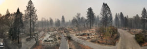
The series of wildfires claimed more than 80 lives and destroyed thousands of buildings across Butte County. However, thanks to UAV companies DJI and DroneDeploy, county and state agencies were able to maximize both disaster response and damage assessment over some 17,000 acres of ravaged landscape.

A cadre of 16 drone teams, led by Alameda County Sheriff’s Office, Stockton Police, Contra Costa County Sheriff’s Office and other agencies, launched 516 flights using DJI Phantom 4 platforms coupled with software analysis by DroneDeploy to collect 70,000 images resulting in 1.4 trillion pixels of data over a two-day period.

Following collection, the data was transported to DroneDeploy’s San Francisco headquarters office for processing. Given the lack of cell and data networks at the fire sites, teams delivered the data via old-school physical disk.  DroneDeploy’s team created a detailed, interactive map within a day after receiving the drone images and data.

After the imagery was georeferenced and stitched into a map format, Butte County officials posted a public fire map to help residents and officials assess the damage.

The detailed footage and maps help determine the condition of homes, which in turn can expedite insurance claims. The data also assists recovery crews, demolition crews, city planners, scientists and researchers, and the general public, to get a better understanding of the situation.

“We’re hoping that one, it will help people understand the devastation that we’re dealing with, understand the very difficult task that we have,” said Butte County Sheriff Kory Honea. “We’re hoping it’ll provide them information that will help them get their insurance claims started.”

“Wildfire victims also made good use of the maps. With entire neighborhoods mapped, homeowners were able to submit the imagery to insurance providers to process claims immediately — a process that traditionally can take days or weeks. Many have used the imagery to gain access to FEMA relief funds for the families affected by the fires.”

Jason Reagan
Jason Reagan

Jason is a longstanding contributor to DroneLife with an avid interest in all things tech. He focuses on anti-drone technologies and the public safety sector; police, fire, and search and rescue.

Beginning his career as a journalist in 1996, Jason has since written and edited thousands of engaging news articles, blog posts, press releases and online content.

Email Jason
TWITTER:@JasonPReagan

LinkedIn 

Subscribe to DroneLife here.

Filed Under: Drone News, Drone News Feeds, Fire and Police, News, safety and security Tagged With: Camp Fire, DJI, DroneDeploy, search and rescue drones

Reader Interactions

Trackbacks

  1. DroneDeploy Gives Free Software program for Hurricane Reduction – Get Best Drone says:
    November 25, 2022 at 10:06 pm

    […] program was utilized in catastrophe response and harm evaluation efforts following the lethal Camp Fire in California. The corporate’s nonprofit department has partnered with greater than 200 universities, in […]

    Reply
  2. DroneDeploy Gives Free Software Program For Hurricane Reduction says:
    January 10, 2022 at 1:54 pm

    […] program was utilized in catastrophe response and harm evaluation efforts following the lethal Camp Fire in California. The corporate’s nonprofit department has partnered with greater than 200 universities, in […]

    Reply
  3. California: Drones Stitch Helpful Aerial Maps in Wake of Deadly Camp Fire – DroneLife says:
    January 9, 2019 at 12:39 pm

    […] California: Drones Stitch Helpful Aerial Maps in Wake of Deadly Camp Fire DroneLife […]

    Reply
  4. California: Drones Stitch Helpful Aerial Maps in Wake of Deadly Camp Fire | Drone Magazine says:
    January 8, 2019 at 6:46 pm

    […] Source […]

    Reply
  5. California: Drones Stitch Helpful Aerial Maps in Wake of Deadly Camp Fire | News and Reviews about Drones, Quadcopter, Camera says:
    January 8, 2019 at 2:30 pm

    […] Source link […]

    Reply

Leave a Reply Cancel reply

Your email address will not be published. Required fields are marked *

Primary Sidebar

LATEST

UK Firm Unveils New High Speed Drone Interceptor

Drone Defence, a UK-based technology firm, has introduced AeroStrike, a high-speed drone interceptor designed to physically counter hostile or unauthorized unmanned…

Continue Reading UK Firm Unveils New High Speed Drone Interceptor

FAA and FBI Establish Comprehensive Drone Restrictions for Super Bowl LX

The Federal Aviation Administration (FAA), in coordination with the Federal Bureau of Investigation (FBI), has established extensive drone restrictions for…

Continue Reading FAA and FBI Establish Comprehensive Drone Restrictions for Super Bowl LX

Draganfly FPV Drones Selected for U.S. Air Force Special Operations Training

Draganfly Inc. has been awarded a contract to supply Flex FPV drones and comprehensive training to U.S. Air Force Special…

Continue Reading Draganfly FPV Drones Selected for U.S. Air Force Special Operations Training

The Companies and Technologies Capturing the Counter-Drone Funding Surge

Governments around the world are no longer debating whether counter-drone systems are necessary. They are deciding which technologies, architectures, and…

Continue Reading The Companies and Technologies Capturing the Counter-Drone Funding Surge

February Public Safety Drone Review: Gemma Alcock of SkyBound Joins the Conversation

Register here to join the live broadcast on Tuesday, February 3 at 3 p.m. EST. The next edition of the…

Continue Reading February Public Safety Drone Review: Gemma Alcock of SkyBound Joins the Conversation

News Media Coalition Letter Challenges FAA’s Expansive NOTAM

By Dronelife Features Editor Jim Magill A coalition of news media associations has sent a letter to the FAA, raising…

Continue Reading News Media Coalition Letter Challenges FAA’s Expansive NOTAM

Ondas Unveils Integrated C-UAS System at Singapore Airshow

Ondas Holdings Inc. (Nasdaq: ONDS) has launched its unified Defence and Security portfolio at the Singapore Airshow 2026, featuring an…

Continue Reading Ondas Unveils Integrated C-UAS System at Singapore Airshow

UAVOS Tests Stratospheric Drone Payload for Earth Observation

UAVOS has announced successful flight testing of an advanced optoelectronic payload system integrated aboard the ApusNeo 18, a solar-powered high-altitude…

Continue Reading UAVOS Tests Stratospheric Drone Payload for Earth Observation

The Drone Industry’s Next Bottleneck Isn’t the Aircraft

Why Networks, Chips, and Trusted Infrastructure Will Decide Who Scales (News and commentary.) Commercial drones are increasingly shaped by forces…

Continue Reading The Drone Industry’s Next Bottleneck Isn’t the Aircraft

UK MOD Selects Seven Partners for Project NYX Apache Wingman Drone Project

The UK Ministry of Defence has invited seven industry partners to advance designs for autonomous drones designed to operate alongside…

Continue Reading UK MOD Selects Seven Partners for Project NYX Apache Wingman Drone Project

Secondary Sidebar

Footer

SPONSORED

Inspired Flight Gremsy IF800 VIO F1 drones geo week

What Will It Take to Strengthen U.S. Drone Manufacturing? A Conversation with Inspired Flight’s CEO

Global Mapper Mobile data collection

Collection Ground Control Points with Global Mapper Mobile

Military Drone Mapping Solutions

How SimActive’s Correlator3D™ is Revolutionizing Military Mapping: An Exclusive Interview with CEO Philippe Simard

Photogrammetry Accuracy Standards

SimActive Photogrammetry Software: Enabling Users to Meet Accuracy Standards for Over 20 Years

NACT Engineering Parrot ANAFI tether indoor shot

Smart Tether for Parrot ANAFI USA from NACT Engineering

Blue Marble, features global mapper, features Blue Marble

Check Out These New Features in Global Mapper v25 from Blue Marble

About Us | Contact Us | Advertise With Us | Write for Us | Privacy Policy | Terms of Service

The Trusted Source for the Business of Drones.

This website uses cookies and third party services. By clicking OK, you are agreeing to our privacy policy. ACCEPT

Manage consent

Privacy Overview

This website uses cookies to improve your experience while you navigate through the website. Out of these, the cookies that are categorized as necessary are stored on your browser as they are essential for the working of basic functionalities of the website. We also use third-party cookies that help us analyze and understand how you use this website. These cookies will be stored in your browser only with your consent. You also have the option to opt-out of these cookies. But opting out of some of these cookies may affect your browsing experience.
Necessary
Always Enabled
Necessary cookies are absolutely essential for the website to function properly. These cookies ensure basic functionalities and security features of the website, anonymously.
CookieDurationDescription
cookielawinfo-checkbox-analytics11 monthsThis cookie is set by GDPR Cookie Consent plugin. The cookie is used to store the user consent for the cookies in the category "Analytics".
cookielawinfo-checkbox-functional11 monthsThe cookie is set by GDPR cookie consent to record the user consent for the cookies in the category "Functional".
cookielawinfo-checkbox-necessary11 monthsThis cookie is set by GDPR Cookie Consent plugin. The cookies is used to store the user consent for the cookies in the category "Necessary".
cookielawinfo-checkbox-others11 monthsThis cookie is set by GDPR Cookie Consent plugin. The cookie is used to store the user consent for the cookies in the category "Other.
cookielawinfo-checkbox-performance11 monthsThis cookie is set by GDPR Cookie Consent plugin. The cookie is used to store the user consent for the cookies in the category "Performance".
viewed_cookie_policy11 monthsThe cookie is set by the GDPR Cookie Consent plugin and is used to store whether or not user has consented to the use of cookies. It does not store any personal data.
Functional
Functional cookies help to perform certain functionalities like sharing the content of the website on social media platforms, collect feedbacks, and other third-party features.
Performance
Performance cookies are used to understand and analyze the key performance indexes of the website which helps in delivering a better user experience for the visitors.
Analytics
Analytical cookies are used to understand how visitors interact with the website. These cookies help provide information on metrics the number of visitors, bounce rate, traffic source, etc.
Advertisement
Advertisement cookies are used to provide visitors with relevant ads and marketing campaigns. These cookies track visitors across websites and collect information to provide customized ads.
Others
Other uncategorized cookies are those that are being analyzed and have not been classified into a category as yet.
SAVE & ACCEPT