
• Skip to main content
  • Skip to secondary menu
  • Skip to primary sidebar
  • Skip to secondary sidebar
  • Skip to footer
  • DroneRacingLife
  • DroneFlyers
  • Newsletter
DroneLife

DRONELIFE

Stay up to date on all the latest Drone News

  • News
  • Products
  • Industries
    • Agriculture
    • Construction
    • Delivery
    • Dual Use
    • Inspection
    • Public Safety
    • Surveying
  • Enthusiasts
  • Regulations
  • Business
  • Video
  • Podcasts

Insitu’s Photogrammetry Payload Pushes Theoretical Limits of Accuracy

July 25, 2018 by staff 2 Comments

Boeing subsidiary Insitu has revealed that its latest advancements in High Accuracy Photogrammetry (HAP) are pushing the theoretical limits of aerial photography at altitude.

Last month Insitu’s latest prototype carried a HAP payload that can capture images accurate to within five centimeters (cm) horizontally and 10cm vertically. Insitu describes this new capability as “ground-breaking”, and says it “now leads the industry in accuracy that can be obtained without ground control from a fixed-wing Unmanned Aerial System traveling more than 100km (62.1 miles) per hour from higher than 1,000 ft.”

Read more: DroneBase & Airbus Aerial Partner to Combine Drone and Satellite Imagery
insitu hap scaneagle photogrammetry

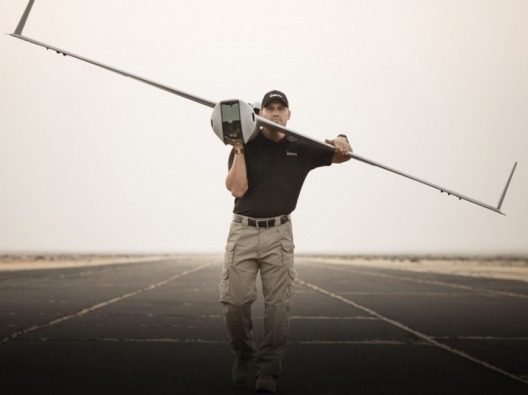
ScanEagle gets an upgrade?

Insitu’s ScanEagle is an ideal platform for the latest HAP technology. More than 150 square kilometers (nearly 60 square miles) can be covered in a single flight, and with the latest HAP payload, imagery with greater accuracy than ever before can be captured.

A HAP payload can be integrated with a Phase One 50 or 100-megapixel camera onto UAS platforms operating as part of Insitu’s INEXATM suite of remote sensing products, information delivery services and solutions for enterprise customers.

The focus for Insitu’s HAP technology is to support mining, oil or gas operations. HAP is ideal for large area surveys required over open cut mining tenements, distributed oil and gas infrastructure, large-scale construction operations, road, rail and pipeline corridors and more.

In remote sensing, the Ground Sampling Distance (GSD) — in a digital photo of the ground from above — is the distance between pixel centers measured on the ground. With recent improvements to Insitu’s HAP payload, accuracies to within two-to-three pixels have been validated.

That means that a 3cm GSD will result in a 3D global accuracy of 6-to-9cm.

HAP provides persistent monitoring

Insitu’s HAP capability provides persistent monitoring and cost-effective inspection of critical assets, capturing the data needed to analyze asset condition. Utilizing HAP, customers optimize operations, and significantly reduce costs through eliminating the need for survey ground control points to achieve survey level accuracy.

The improved positional accuracy derived from the HAP payload provides even better input into data analytics. In the mining industry, HAP will allow fast production of more accurate orthomosaics over a wide area, enabling precise volumetric and stockpile measurements.

In environments with bare earth and limited vegetation, Insitu argue that their HAP payload now represents an alternative to LiDAR, with the ability to produce imagery data as accurate as most LiDAR payloads at a lower cost.

HAP also is available in a multi-spectral format which gives machine learning algorithms the information needed for automated asset inspection, including vegetation encroachment, standing water, infrastructure anomalies, and more.

“Insitu is geared to provide turnkey solutions in aerial data collection and remote sensing, and the increased HAP accuracy we have achieved is an exciting addition to our suite of solutions to drive efficiencies in our customers’ resource sector operations,” said Andrew Duggan, vice president, Insitu Commercial.

“We are excited by the possibilities these innovations in aerial imagery will bring to our customers”.


Filed Under: Business and Finance, Drone News Feeds, Fixed wing, Imaging, Mining and Aggregates, News, Sensors Tagged With: Andrew Duggan, Boeing, Insitu, LIDAR, photogrammetry, ScanEagle

Reader Interactions

Trackbacks

  1. Amazon Patents Aerial Fulfillment Centers for Improved Drone Delivery | Drone "Ki" says:
    August 25, 2018 at 12:55 am

    […] Boeing subsidiary Insitu has revealed that its latest advancements in High Accuracy Photogrammetry (HAP) are pushing the theoretical limits of aerial photography at altitude. Last month Insitu’s latest prototype carried a HAP payload that can capture images accurate to within five centimeters (cm) horizontally and 10cm vertically. Insitu describes this new capability as “ground-breaking”, and […] The post Insitu’s Photogrammetry Payload Pushes Theoretical Limits of Accuracy appeared fiSee Original Article […]

    Reply
  2. Insitu’s Photogrammetry Payload Pushes Theoretical Limits of Accuracy - Drones Crunch says:
    July 26, 2018 at 5:43 am

    […] DRONELIFE […]

    Reply

Leave a Reply Cancel reply

Your email address will not be published. Required fields are marked *

Primary Sidebar

LATEST

From Power Lines to Mine Shafts: Lidar Expands the Reach of Drone Mapping

Ouster partnerships with GeoCue and Flyability show how next-generation lidar is supporting applications above infrastructure and deep inside confined spaces…

Continue Reading From Power Lines to Mine Shafts: Lidar Expands the Reach of Drone Mapping

SimActive Adds Interactive Mode to Correlator3D for Faster Photogrammetry Workflows

The new interactive mode runs multiple scripts in a single session, cutting delays between operations for repetitive photogrammetry pipelines. SimActive…

Continue Reading SimActive Adds Interactive Mode to Correlator3D for Faster Photogrammetry Workflows

Texas Senators Call for Drone-Powered “Smart Wall”

By Dronelife Features Editor Jim Magill Facing threats from the federal government to build a border wall or other physical…

Continue Reading Texas Senators Call for Drone-Powered “Smart Wall”

When Drones Generate 6,000 Images, Who Looks at Them? AI’s Real Role in Commercial Drone Operations

Commercial UAV Expo panelists point to data analysis, scale and human oversight as the near-term value of artificial intelligence. As…

Continue Reading When Drones Generate 6,000 Images, Who Looks at Them? AI’s Real Role in Commercial Drone Operations

Bechtel and Cyberhawk Expand Eight-Year Collaboration on AI-Driven Drone Construction Monitoring

The two companies formalize their partnership to scale iHawk drone analytics, autonomous data capture and AI-assisted site analysis on live…

Continue Reading Bechtel and Cyberhawk Expand Eight-Year Collaboration on AI-Driven Drone Construction Monitoring

Powerus Signs $22.3M Counter-UAS Deal With Private Middle East Oil Firm

By Dronelife Features Editor Jim Magill Powerus counter-UAS deal signals a new private sector paradigm. In what might be the…

Continue Reading Powerus Signs $22.3M Counter-UAS Deal With Private Middle East Oil Firm

Robinson’s “Era of Both” Expands from Tactical Drones to Heavy-Lift UAS

Full-size unmanned helicopter demonstrates deck landings and cargo operations as Robinson shows off range: from small tactical drones to heavy-lift…

Continue Reading Robinson’s “Era of Both” Expands from Tactical Drones to Heavy-Lift UAS

TSA Seeks Drone Industry Input on Security Requirements for Part 108 BVLOS Operations

Technical roundtables will examine how existing BVLOS security practices could help operators comply with new requirements For years, the drone…

Continue Reading TSA Seeks Drone Industry Input on Security Requirements for Part 108 BVLOS Operations

FCC “Military-Grade” Drone Proposal Draws Overwhelming Opposition in Public Comments

Pilot Institute analysis finds 98.6% of readable filings opposed the proposed restrictions as writte Review of 3,824 readable filings finds…

Continue Reading FCC “Military-Grade” Drone Proposal Draws Overwhelming Opposition in Public Comments

Open Platform Strategy Offers Flexibility as the U.S. Drone Market Shifts: DRONELIFE Exclusive Interview

Blue UAS manufacturer Inspired Flight sees an open payload ecosystem as a way to extend aircraft value and give operators…

Continue Reading Open Platform Strategy Offers Flexibility as the U.S. Drone Market Shifts: DRONELIFE Exclusive Interview

Secondary Sidebar

Footer

SPONSORED

What Is the Best Commercial Cleaning Drone in 2026? Specs, Prices, and a Head-to-Head Comparison

Inspired Flight Gremsy IF800 VIO F1 drones geo week

What Will It Take to Strengthen U.S. Drone Manufacturing? A Conversation with Inspired Flight’s CEO

Global Mapper Mobile data collection

Collection Ground Control Points with Global Mapper Mobile

Military Drone Mapping Solutions

How SimActive’s Correlator3D™ is Revolutionizing Military Mapping: An Exclusive Interview with CEO Philippe Simard

Photogrammetry Accuracy Standards

SimActive Photogrammetry Software: Enabling Users to Meet Accuracy Standards for Over 20 Years

NACT Engineering Parrot ANAFI tether indoor shot

Smart Tether for Parrot ANAFI USA from NACT Engineering

About Us | Contact Us | Advertise With Us | Write for Us | Privacy Policy | Terms of Service

The Trusted Source for the Business of Drones.

This website uses cookies and third party services. By clicking OK, you are agreeing to our privacy policy. ACCEPT

Manage consent

Privacy Overview

This website uses cookies to improve your experience while you navigate through the website. Out of these, the cookies that are categorized as necessary are stored on your browser as they are essential for the working of basic functionalities of the website. We also use third-party cookies that help us analyze and understand how you use this website. These cookies will be stored in your browser only with your consent. You also have the option to opt-out of these cookies. But opting out of some of these cookies may affect your browsing experience.
Necessary
Always Enabled
Necessary cookies are absolutely essential for the website to function properly. These cookies ensure basic functionalities and security features of the website, anonymously.
CookieDurationDescription
cookielawinfo-checkbox-analytics11 monthsThis cookie is set by GDPR Cookie Consent plugin. The cookie is used to store the user consent for the cookies in the category "Analytics".
cookielawinfo-checkbox-functional11 monthsThe cookie is set by GDPR cookie consent to record the user consent for the cookies in the category "Functional".
cookielawinfo-checkbox-necessary11 monthsThis cookie is set by GDPR Cookie Consent plugin. The cookies is used to store the user consent for the cookies in the category "Necessary".
cookielawinfo-checkbox-others11 monthsThis cookie is set by GDPR Cookie Consent plugin. The cookie is used to store the user consent for the cookies in the category "Other.
cookielawinfo-checkbox-performance11 monthsThis cookie is set by GDPR Cookie Consent plugin. The cookie is used to store the user consent for the cookies in the category "Performance".
viewed_cookie_policy11 monthsThe cookie is set by the GDPR Cookie Consent plugin and is used to store whether or not user has consented to the use of cookies. It does not store any personal data.
Functional
Functional cookies help to perform certain functionalities like sharing the content of the website on social media platforms, collect feedbacks, and other third-party features.
Performance
Performance cookies are used to understand and analyze the key performance indexes of the website which helps in delivering a better user experience for the visitors.
Analytics
Analytical cookies are used to understand how visitors interact with the website. These cookies help provide information on metrics the number of visitors, bounce rate, traffic source, etc.
Advertisement
Advertisement cookies are used to provide visitors with relevant ads and marketing campaigns. These cookies track visitors across websites and collect information to provide customized ads.
Others
Other uncategorized cookies are those that are being analyzed and have not been classified into a category as yet.
SAVE & ACCEPT



