• Skip to main content
  • Skip to secondary menu
  • Skip to primary sidebar
  • Skip to secondary sidebar
  • Skip to footer
  • DroneRacingLife
  • DroneFlyers
  • Newsletter
DroneLife

DRONELIFE

Stay up to date on all the latest Drone News

  • News
  • Products
  • Industries
    • Agriculture
    • Construction
    • Delivery
    • Dual Use
    • Inspection
    • Public Safety
    • Surveying
  • Enthusiasts
  • Regulations
  • Business
  • Video
  • Podcasts

High Resolution Thermal Imaging for Drones: Changing the Game on Building Inspections

July 25, 2018 by Miriam McNabb 3 Comments

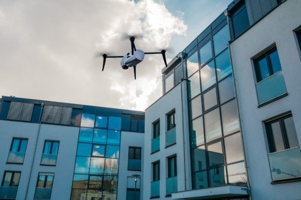
 Kespry, the leading drone-based aerial intelligence solution provider, today announced new high-resolution thermal inspection capabilities for commercial property and industrial facilities.

It’s a technology that may mean inspections by drone become standard operating procedure.  Drones already provide efficiencies in thermal inspections, but only go halfway – they can’t always eliminate the need for a manual inspection.  With this new solution, Kespry is raising the ROI for drone inspections – and meeting the needs of enterprise customers.

“Where other commercial drone vendors go wrong is that they believe simply providing a thermal overlay is sufficient,” George Mathew, CEO of Kespry, tells DRONELIFE. “We know from our work with insurers and roofers that for thermal data to be valuable, it has to integrated into the inspection workflow with dimensional data and highly accurate to prevent a drone inspection being followed up by a long manual inspection to pinpoint the location of issues.”

The following is taken from a Kespry press release:

Thermal building inspection is critical for organizations as they look to reduce investment risk in the $750 billion combined commercial real estate, insurance, and management industry. Until today, property managers, owners, and insurers were forced to rely on expensive and inaccurate manual inspections or low-resolution, first-generation drones to determine the health of a roof. By providing a fully-autonomous, simple-to-use, and high-resolution drone inspection solution, Kespry is reducing the cost of inspections for large-scale commercial buildings and delivering more accurate damage assessment.

For the commercial property industry, drone roof inspections including thermal imaging solve two critical problems. First, they identify previously-unseen damage to roofs, mechanical elements, piping, and other infrastructure unapparent in traditionally-infrequent manual inspections. This enables proactive and preventative maintenance, and uncovers minor issues before they can turn into highly-costly, impactful problems. Secondly, they enable fast and safe inspections to support insurance underwriting and risk mitigation during property ownership transactions.

“Accuracy really matters when billions of dollars of property and facilities are at risk,” said George Mathew, CEO of Kespry. “Manual inspections and first-generation drone flights are slow and inaccurate ways of attempting to understand the state of a roof and the risk that issues may have on organizations’ productivity. These earlier approaches leave surveyors, risk assessors, and roof inspectors guessing at the specific location of leaks, blocked drains, or damage to building infrastructure, all of which can have serious impacts on assets inside. The new Kespry solution for commercial roof inspection solves these problems.”

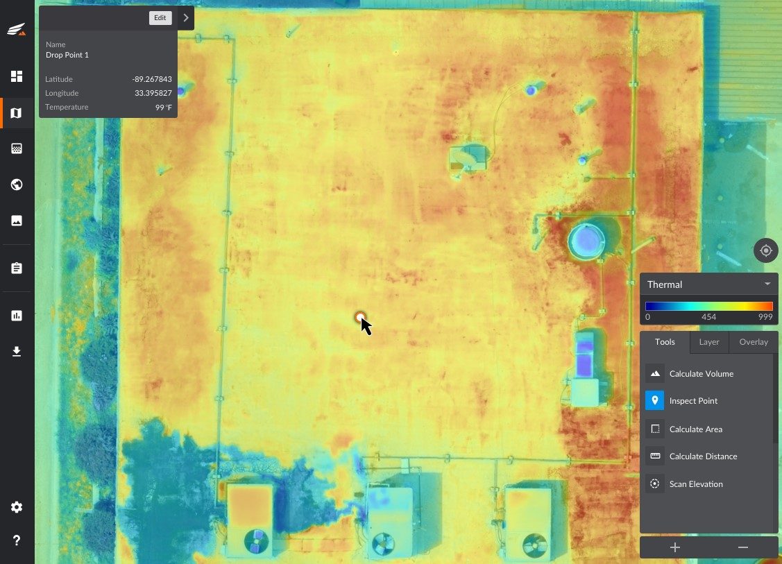
Kespry’s thermal inspection solution is based on radiometric temperature analysis, providing actionable data to people inspecting roofs. Radiometric analysis means that a specific temperature is displayed for a specific point on a roof. In contrast, non-radiometric thermal drone data simply shows general temperature differences and changes in an area, making it hard to determine whether there is a specific point of damage or concern.

Additionally, Kespry uniquely creates thermal inspection views that combines pixel-level thermal data with high-resolution imagery. This enables users to granularly determine the specific location of heat damage rather than rely on the grainy, poorly-defined visual cues of earlier drone-based solutions. With Kespry, more accurate damage assessments can be conducted, reducing the need for follow-up manual inspections once a thermal anomaly is identified.

The Kespry commercial roof solution also incorporates accurate roof dimensional analysis. With this feature, users can get the dimensional data they need to complete an inspection report or pinpoint areas of concern faster and at lower costs.

“For too long, commercial property firms have relied on randomly-conducted, dangerous manual roof inspections to protect billions of dollars of property,” said Mathew. “We know commercial property professionals must juggle multiple responsibilities. By providing actionable, radiometric-thermal data integrated with high-resolution visual data, and delivering roof dimension data, Kespry’s commercial roof inspection solution gives owners and insurers less to worry about, while saving them millions of dollars  in repair and lost productivity costs.”


Miriam McNabb

Miriam McNabb is the Editor-in-Chief of DRONELIFE and CEO of JobForDrones, a professional drone services marketplace, and a fascinated observer of the emerging drone industry and the regulatory environment for drones. Miriam has penned over 3,000 articles focused on the commercial drone space and is an international speaker and recognized figure in the industry.  Miriam has a degree from the University of Chicago and over 20 years of experience in high tech sales and marketing for new technologies.
For drone industry consulting or writing, Email Miriam.

TWITTER:@spaldingbarker

Subscribe to DroneLife here.

Filed Under: Drone News Feeds, Inspection, Insurance, News Tagged With: commercial drone applications, Commercial Drones, drone inspections, drone thermal imaging, Drones for Insurance, George Mathew, industrial drones, Kespry, roof inspections, Thermal Imaging

Reader Interactions

Trackbacks

  1. Top benefits of inspecting Cell Towers with drones – Mira Spatial says:
    May 8, 2025 at 2:10 pm

    […] High-Resolution Imagery: Drones can provide images with incredible clarity, allowing for the detection of minute structural issues that may go unnoticed during manual inspections. […]

    Reply
  2. High Resolution Thermal Imaging for Drones: Changing the Game on Building Inspections | Drone Flying Law says:
    July 27, 2018 at 11:00 am

    […] post High Resolution Thermal Imaging for Drones: Changing the Game on Building Inspections appeared first on […]

    Reply
  3. High Resolution Thermal Imaging for Drones: Changing the Game on Building Inspections | My Blog says:
    July 25, 2018 at 9:56 am

    […] Original Article […]

    Reply

Leave a Reply Cancel reply

Your email address will not be published. Required fields are marked *

Primary Sidebar

LATEST

SimActive Integrates Phase One iXM-FS130 for High-Resolution Aerial Mapping

Correlator3D enables sub-centimeter processing for fixed-wing survey missions SimActive has announced full support for the Phase One iXM-FS130 sensor in…

Continue Reading SimActive Integrates Phase One iXM-FS130 for High-Resolution Aerial Mapping

WISPR Systems’ SkyScout 2+ Achieves Green UAS Certification

WISPR Systems announced that its SkyScout 2+ has earned Green UAS Certification from the Association for Uncrewed Vehicle Systems International (AUVSI). The designation confirms…

Continue Reading WISPR Systems’ SkyScout 2+ Achieves Green UAS Certification

EagleNXT Expands in Europe as Defense Drone Market Demand Grows

European Market for Defense Drones, Counter-UAS Grows By Dronelife Features Editor Jim Magill As western European nations contend with the…

Continue Reading EagleNXT Expands in Europe as Defense Drone Market Demand Grows

AeroDefense Launches No-Cost Drone Detection Access Program for Law Enforcement

AirWarden Essentials customers can now share drone detection data with SLTT, DHS, and FBI partners at no added cost AeroDefense…

Continue Reading AeroDefense Launches No-Cost Drone Detection Access Program for Law Enforcement

Versaterm Acquires Aloft to Expand Drone Capabilities for Public Safety

Deal adds FAA-approved airspace intelligence to DroneSense platform Versaterm has announced the acquisition of Aloft, an FAA-approved provider of airspace…

Continue Reading Versaterm Acquires Aloft to Expand Drone Capabilities for Public Safety

Trojan Horse or Trade Dispute? Texas Attorney General Targets Anzu in High-Stakes Drone Lawsuit

Texas AG sues Anzu, claims company sells DJI clones By DRONELIFE Features Editor Jim Magill Claiming that the company is…

Continue Reading Trojan Horse or Trade Dispute? Texas Attorney General Targets Anzu in High-Stakes Drone Lawsuit

Geo Week to Relocate to Salt Lake City in 2027

Leading Geospatial Event Moves to Utah’s Expanding Technology Hub Geo Week will relocate to Salt Lake City, Utah in 2027,…

Continue Reading Geo Week to Relocate to Salt Lake City in 2027

Eric Trump Invests in XTEND as Israeli Drone Firm Announces Plan to Go Public via Nasdaq Merger

AI-powered robotics company targets $1.5B valuation in U.S. listing Israeli drone and robotics company XTEND has announced plans to go…

Continue Reading Eric Trump Invests in XTEND as Israeli Drone Firm Announces Plan to Go Public via Nasdaq Merger

New Partnership Building Farming Drone Batteries in Texas

KULR Technology Group and Hylio have entered a joint collaboration to produce NDAA-compliant battery systems for agricultural drones built in…

Continue Reading New Partnership Building Farming Drone Batteries in Texas

FlytBase Unveils FlytBase One Management System

FlytBase has introduced FlytBase One, a unified control platform built to connect autonomous drones, robots, and physical infrastructure. The company also…

Continue Reading FlytBase Unveils FlytBase One Management System

Secondary Sidebar

Footer

SPONSORED

Inspired Flight Gremsy IF800 VIO F1 drones geo week

What Will It Take to Strengthen U.S. Drone Manufacturing? A Conversation with Inspired Flight’s CEO

Global Mapper Mobile data collection

Collection Ground Control Points with Global Mapper Mobile

Military Drone Mapping Solutions

How SimActive’s Correlator3D™ is Revolutionizing Military Mapping: An Exclusive Interview with CEO Philippe Simard

Photogrammetry Accuracy Standards

SimActive Photogrammetry Software: Enabling Users to Meet Accuracy Standards for Over 20 Years

NACT Engineering Parrot ANAFI tether indoor shot

Smart Tether for Parrot ANAFI USA from NACT Engineering

Blue Marble, features global mapper, features Blue Marble

Check Out These New Features in Global Mapper v25 from Blue Marble

About Us | Contact Us | Advertise With Us | Write for Us | Privacy Policy | Terms of Service

The Trusted Source for the Business of Drones.

This website uses cookies and third party services. By clicking OK, you are agreeing to our privacy policy. ACCEPT

Manage consent

Privacy Overview

This website uses cookies to improve your experience while you navigate through the website. Out of these, the cookies that are categorized as necessary are stored on your browser as they are essential for the working of basic functionalities of the website. We also use third-party cookies that help us analyze and understand how you use this website. These cookies will be stored in your browser only with your consent. You also have the option to opt-out of these cookies. But opting out of some of these cookies may affect your browsing experience.
Necessary
Always Enabled
Necessary cookies are absolutely essential for the website to function properly. These cookies ensure basic functionalities and security features of the website, anonymously.
CookieDurationDescription
cookielawinfo-checkbox-analytics11 monthsThis cookie is set by GDPR Cookie Consent plugin. The cookie is used to store the user consent for the cookies in the category "Analytics".
cookielawinfo-checkbox-functional11 monthsThe cookie is set by GDPR cookie consent to record the user consent for the cookies in the category "Functional".
cookielawinfo-checkbox-necessary11 monthsThis cookie is set by GDPR Cookie Consent plugin. The cookies is used to store the user consent for the cookies in the category "Necessary".
cookielawinfo-checkbox-others11 monthsThis cookie is set by GDPR Cookie Consent plugin. The cookie is used to store the user consent for the cookies in the category "Other.
cookielawinfo-checkbox-performance11 monthsThis cookie is set by GDPR Cookie Consent plugin. The cookie is used to store the user consent for the cookies in the category "Performance".
viewed_cookie_policy11 monthsThe cookie is set by the GDPR Cookie Consent plugin and is used to store whether or not user has consented to the use of cookies. It does not store any personal data.
Functional
Functional cookies help to perform certain functionalities like sharing the content of the website on social media platforms, collect feedbacks, and other third-party features.
Performance
Performance cookies are used to understand and analyze the key performance indexes of the website which helps in delivering a better user experience for the visitors.
Analytics
Analytical cookies are used to understand how visitors interact with the website. These cookies help provide information on metrics the number of visitors, bounce rate, traffic source, etc.
Advertisement
Advertisement cookies are used to provide visitors with relevant ads and marketing campaigns. These cookies track visitors across websites and collect information to provide customized ads.
Others
Other uncategorized cookies are those that are being analyzed and have not been classified into a category as yet.
SAVE & ACCEPT