• Skip to main content
  • Skip to secondary menu
  • Skip to primary sidebar
  • Skip to secondary sidebar
  • Skip to footer
  • DroneRacingLife
  • DroneFlyers
  • Newsletter
DroneLife

DRONELIFE

Stay up to date on all the latest Drone News

  • News
  • Products
  • Industries
    • Agriculture
    • Construction
    • Delivery
    • Dual Use
    • Inspection
    • Public Safety
    • Surveying
  • Enthusiasts
  • Regulations
  • Business
  • Video
  • Podcasts

AirMap to Test UTM System in New Zealand

December 14, 2017 by Frank Schroth 6 Comments

AirMap

Unmanned Traffic Management (UTM), a comprehensive system for managing and monitoring drone flights beyond visual line of sight (BVLS), is something of a regulatory Wild West show here in the states with a number of technologies and players vying to be part of the eventual solution. One of those players is AirMap. In what may prove to be an excellent test case for a broader deployment, AirMap is working with Airways New Zealand to deploy a UTM system that enables safe and compliant drone flights for a three-month trial in the Canterbury and Queenstown regions of New Zealand.

Drone flights in New Zealand, like everywhere else, are growing at a rapid rate. Over the past three years, weekly recorded drone flights in the country’s controlled airspace have increased 20-fold.

In a release, AirMap writes:

The Airways-AirMap trial brings digital authorization capabilities first deployed in the U.S. for the LAANC program to New Zealand. Using AirMap’s free iOS and Android apps, drone operators can request digital airspace and public land owner approvals required by New Zealand’s Civil Aviation Authority. Digital authorization is available from the Christchurch, Queenstown, and Wanaka airports and on public lands in the Christchurch City, Selwyn, and Queenstown Lakes District Councils, including parks and reserves. Commercial and recreational drone operators are invited to take part in the trial, which is currently underway and will significantly simplify and streamline the authorization process.

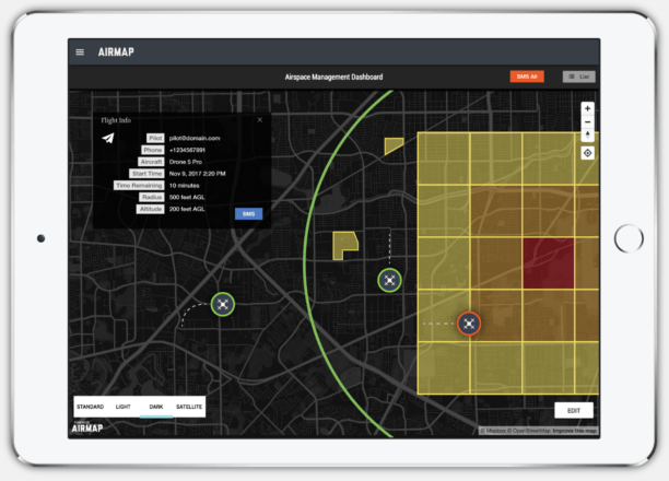
Airspace managers participating in the trial are using the AirMap airspace management dashboard to provide digital flight authorizations and share real-time updates about the location of events, community gatherings, emergencies, and other areas to avoid. This information is delivered immediately to the AirMap app to enable safer flights and more comprehensive situational awareness.

Airways New Zealand is the key enabler of the region’s aviation system and a leading provider of air traffic management services worldwide, serving more than 65 countries and managing more than 1 million air traffic movements each year. “The trial is an important step in investigating how Airways could develop a nationwide UTM system that safely integrates UAVs into New Zealand’s wider air traffic control network,” said Airways Chief Executive Graeme Sumner. “There is potential for New Zealand to become a test-bed for the UAV industry through the implementation of a system that supports growth and development in a safe manner.”

“We’re very excited to help New Zealand’s drone pilots more easily and safely access the airspace,” said Ben Marcus, AirMap CEO. “With the world watching, Airways and AirMap are demonstrating how UTM technologies can safely open the skies to high-scale drone operations, today.”

Frank Schroth
Frank Schroth

Frank Schroth is editor in chief of DroneLife, the authoritative source for news and analysis on the drone industry: it’s people, products, trends, and events.
Email Frank
TWITTER:@fschroth


Filed Under: Applications, UTM Tagged With: AirMap, BVLOS, LAANC

Reader Interactions

Trackbacks

  1. AirMap to Test UTM System in New Zealand | News and Reviews about Drones, Quadcopter, Camera says:
    December 18, 2017 at 2:53 am

    […] Source link […]

    Reply
  2. AirMap to Test UTM System in New Zealand - Drone Services Company | Aerial Photo and Video | Miami Florida says:
    December 17, 2017 at 8:03 pm

    […] post AirMap to Test UTM System in New Zealand appeared first on […]

    Reply
  3. AirMap to Test UTM System in New Zealand | Drone Magazine says:
    December 16, 2017 at 4:30 pm

    […] Source […]

    Reply
  4. AirMap to Test UTM System in New Zealand – c says:
    December 15, 2017 at 10:20 am

    […] Posted on December 15, 2017 by Benjamin Chao AirMap to Test UTM System in New Zealand […]

    Reply
  5. AirMap to Test UTM System in New Zealand – Dronegram says:
    December 15, 2017 at 9:08 am

    […] post AirMap to Test UTM System in New Zealand appeared first on […]

    Reply
  6. AirMap to Test UTM System in New Zealand - Latest & Breaking News says:
    December 13, 2017 at 8:27 am

    […] (adsbygoogle = window.adsbygoogle || []).push({});Source link […]

    Reply

Leave a Reply Cancel reply

Your email address will not be published. Required fields are marked *

Primary Sidebar

LATEST

SimActive Correlator3D Supports Large-Scale Green Hydrogen Mapping in Chile

Geo4D used the photogrammetry platform to process high-resolution aerial imagery covering more than 100,000 hectares in Patagonia. SimActive’s Correlator3D photogrammetry…

Continue Reading SimActive Correlator3D Supports Large-Scale Green Hydrogen Mapping in Chile

Michigan Drone Lawsuit Challenges Restrictions on Flights Near Police Operations

Michigan man sues sheriff’s department over state’s drone law By DRONELIFE Features Editor Jim Magill A Michigan-based freelance journalist has…

Continue Reading Michigan Drone Lawsuit Challenges Restrictions on Flights Near Police Operations

Michigan Awards $2 Million for Five Advanced Air Mobility Projects

State agencies will test drones and aerial technologies for environmental monitoring, wildfire response, infrastructure, public safety and agriculture. Michigan has…

Continue Reading Michigan Awards $2 Million for Five Advanced Air Mobility Projects

FCC Revokes Drone Approvals After U.S. Assembler Denies Any Connection

Odyssey Robot claimed its equipment was made and assembled in the U.S.; an FCC investigation found otherwis The Federal Communications…

Continue Reading FCC Revokes Drone Approvals After U.S. Assembler Denies Any Connection

FlybyOps Launches Enterprise Platform for Scaling BVLOS and Autonomous Drone Operations

Finland-based platform aims to help operators manage compliance, risk and operational oversight as drone programs grow in size and complexity…

Continue Reading FlybyOps Launches Enterprise Platform for Scaling BVLOS and Autonomous Drone Operations

With Nexus, Airwise Solutions Champions “Free and Open” Sensor Integration

New airspace-awareness platform brings radar, RF, Remote ID, ADS-B and other operational data into a unified operating pictur Airwise Solutions…

Continue Reading With Nexus, Airwise Solutions Champions “Free and Open” Sensor Integration

ePropelled Secures $60 Million in U.S. Government Funding to Expand Drone Propulsion Manufacturing

New Hampshire expansion will quadruple production capacity as the U.S. works to build a domestic supply chain for critical drone…

Continue Reading ePropelled Secures $60 Million in U.S. Government Funding to Expand Drone Propulsion Manufacturing

From Border Security to Biosecurity: Drones Join the Fight Against New World Screwworm

USDA has conducted more than 1,000 drone surveillance flights in Texas, while the Department of Homeland Security brings border surveillance…

Continue Reading From Border Security to Biosecurity: Drones Join the Fight Against New World Screwworm

BRINC Brings Wildfire and Smoke Tracking Into Drone Operations

New LiveOps layers integrate NOAA fire and smoke data to give public safety agencies a more complete operational picture BRINC…

Continue Reading BRINC Brings Wildfire and Smoke Tracking Into Drone Operations

Drones Bring Whole Blood Directly to Trauma Scenes

Hillsborough County program aims to deliver blood to first responders in under three minutes Archer First Response Systems (ArcherFRS) is…

Continue Reading Drones Bring Whole Blood Directly to Trauma Scenes

Secondary Sidebar

Footer

SPONSORED

Inspired Flight Gremsy IF800 VIO F1 drones geo week

What Will It Take to Strengthen U.S. Drone Manufacturing? A Conversation with Inspired Flight’s CEO

Global Mapper Mobile data collection

Collection Ground Control Points with Global Mapper Mobile

Military Drone Mapping Solutions

How SimActive’s Correlator3D™ is Revolutionizing Military Mapping: An Exclusive Interview with CEO Philippe Simard

Photogrammetry Accuracy Standards

SimActive Photogrammetry Software: Enabling Users to Meet Accuracy Standards for Over 20 Years

NACT Engineering Parrot ANAFI tether indoor shot

Smart Tether for Parrot ANAFI USA from NACT Engineering

Blue Marble, features global mapper, features Blue Marble

Check Out These New Features in Global Mapper v25 from Blue Marble

About Us | Contact Us | Advertise With Us | Write for Us | Privacy Policy | Terms of Service

The Trusted Source for the Business of Drones.

This website uses cookies and third party services. By clicking OK, you are agreeing to our privacy policy. ACCEPT

Manage consent

Privacy Overview

This website uses cookies to improve your experience while you navigate through the website. Out of these, the cookies that are categorized as necessary are stored on your browser as they are essential for the working of basic functionalities of the website. We also use third-party cookies that help us analyze and understand how you use this website. These cookies will be stored in your browser only with your consent. You also have the option to opt-out of these cookies. But opting out of some of these cookies may affect your browsing experience.
Necessary
Always Enabled
Necessary cookies are absolutely essential for the website to function properly. These cookies ensure basic functionalities and security features of the website, anonymously.
CookieDurationDescription
cookielawinfo-checkbox-analytics11 monthsThis cookie is set by GDPR Cookie Consent plugin. The cookie is used to store the user consent for the cookies in the category "Analytics".
cookielawinfo-checkbox-functional11 monthsThe cookie is set by GDPR cookie consent to record the user consent for the cookies in the category "Functional".
cookielawinfo-checkbox-necessary11 monthsThis cookie is set by GDPR Cookie Consent plugin. The cookies is used to store the user consent for the cookies in the category "Necessary".
cookielawinfo-checkbox-others11 monthsThis cookie is set by GDPR Cookie Consent plugin. The cookie is used to store the user consent for the cookies in the category "Other.
cookielawinfo-checkbox-performance11 monthsThis cookie is set by GDPR Cookie Consent plugin. The cookie is used to store the user consent for the cookies in the category "Performance".
viewed_cookie_policy11 monthsThe cookie is set by the GDPR Cookie Consent plugin and is used to store whether or not user has consented to the use of cookies. It does not store any personal data.
Functional
Functional cookies help to perform certain functionalities like sharing the content of the website on social media platforms, collect feedbacks, and other third-party features.
Performance
Performance cookies are used to understand and analyze the key performance indexes of the website which helps in delivering a better user experience for the visitors.
Analytics
Analytical cookies are used to understand how visitors interact with the website. These cookies help provide information on metrics the number of visitors, bounce rate, traffic source, etc.
Advertisement
Advertisement cookies are used to provide visitors with relevant ads and marketing campaigns. These cookies track visitors across websites and collect information to provide customized ads.
Others
Other uncategorized cookies are those that are being analyzed and have not been classified into a category as yet.
SAVE & ACCEPT