• Skip to main content
  • Skip to secondary menu
  • Skip to primary sidebar
  • Skip to secondary sidebar
  • Skip to footer
  • DroneRacingLife
  • DroneFlyers
  • Newsletter
DroneLife

DRONELIFE

Stay up to date on all the latest Drone News

  • News
  • Products
  • Industries
    • Agriculture
    • Construction
    • Delivery
    • Dual Use
    • Inspection
    • Public Safety
    • Surveying
  • Enthusiasts
  • Regulations
  • Business
  • Video
  • Podcasts

PrecisionHawk and Corning Collaborate to Provide Hyperspectral Data via Drone

April 12, 2017 by Frank Schroth 1 Comment

Corning Incorporated is moving into the drone industry, selling its latest hyperspectral sensor in partnership with leading drone platform provider PrecisionHawk. In doing so, PrecisionHawk gets at least a temporary lead over competitors in delivering a high level of drone imaging data intelligence.

Historically, low-altitude data collection using hyperspectral sensors has been difficult to achieve because of operational complexities. This partnership makes it possible for novice users to properly and effectively collect high-resolution hyperspectral data using a PrecisionHawk drone package, which includes a drone coupled with processing and analytics software.

This integration will lay the groundwork for creating extensive data libraries that hone in on spectral bands to generate extremely tailored applications across enterprise verticals like agriculture, mining and energy. For example, pinpointing specific diseases in an agricultural field.

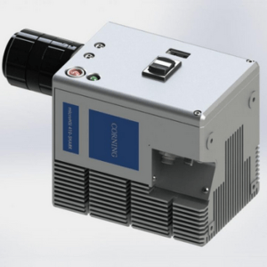
PrecisionHawk announced it will collaborate with Corning Incorporated (NYSE: GLW) to sell the Corning microHSI 410-SHARK hyperspectral camera coupled with PrecisionHawk’s platform for collection and analysis of drone data. The sensor is capable of on-board processing which produces calibrated, geo-referenced hyper-cubes post flight.

The massive research potential brought to light by these low-altitude remote sensing capabilities will allow for the creation of new spectral libraries that can generate extremely tailored applications across enterprise verticals including agriculture, mining, construction, energy, and insurance industries.

“Historically, low-altitude data collection using hyperspectral sensors has been very difficult to achieve due to operational complexities,” said Richard Zacaroli, commercial business development manager, Hyperspectral Imaging Products, Corning Incorporated. “Due to the integration between Corning’s revolutionary sensors and PrecisionHawk’s drone and data suite, it’s now possible for novice users to properly and effectively collect high-resolution hyperspectral data.”

The microHSI 410-SHARK visible to near-infrared (VNIR) hyperspectral imager is equipped with 154 spectral bands and a spectral range of 400-1,000 nanometers.

The sensor can be mounted on several of PrecisionHawk’s drone platforms for simplified data collection, which can be purchased starting at $7,100.

“Hyperspectral imagery is a tremendously rich dataset that helps researchers pick up vital information over a detailed spectrum for analysis,” said Thomas Haun, senior vice president of Partnerships at PrecisionHawk. “With Corning’s 154-band hyperspectral product, researchers can obtain and create a wide variety of spectral maps to hone in on specific problems the customer is trying to solve that would otherwise not be identifiable with visual or multispectral sensors.”

The sensor joins PrecisionHawk’s robust sensor line and will be offered as an optional add-on to drone data packages featuring DJI’S M100 and M600, which are integrated with PrecisionHawk’s flight planning, processing and analysis tools. At low altitudes, data obtained through the microHSIâ„¢ 410-SHARK creates high-resolution maps not available through traditional collection methodologies.

PrecisionHawk and Corning’s combined offering puts the power of advanced science into a high- performance and cost-effective package that could drive the future of commercial drones.

PercisionHawk is the first drone firm to adopt and integrate the Corning sensor; but it is unlikely to the the only one.

Frank Schroth
Frank Schroth

Frank Schroth is editor in chief of DroneLife, the authoritative source for news and analysis on the drone industry: it’s people, products, trends, and events.
Email Frank
TWITTER:@fschroth

Filed Under: Applications, Drone News Feeds, Imaging, News, Products Tagged With: Corning, Hyperspectral imaging, PrecisionHawk, Sensore

Reader Interactions

Trackbacks

  1. PrecisionHawk and Corning Collaborate to Provide Hyperspectral Data via Drone – İnsansız Hava Araçları (İHA) Platformu says:
    April 13, 2017 at 9:39 am

    […] https://dronelife.com/2017/04/12/precisionhawk-corning-collaborate-hyperspectral-data-via-drone/ […]

    Reply

Leave a Reply Cancel reply

Your email address will not be published. Required fields are marked *

Primary Sidebar

LATEST

Unprepared for Drone War? Europe and the US Face Procurement Crisis

Military drone procurement is becoming one of the defining defense challenges of this decade. Europe is confronting a paradox at…

Continue Reading Unprepared for Drone War? Europe and the US Face Procurement Crisis

Designing Resilient Roads on Java’s Southern Coast: A Blue Marble Geographics Case Study

As governments invest in infrastructure to unlock tourism and regional growth, the challenge is no longer just building roads. It…

Continue Reading Designing Resilient Roads on Java’s Southern Coast: A Blue Marble Geographics Case Study

Woolpert and Saildrone Deploy Autonomous USV for NOAA Seafloor Mapping Near Mariana Islands

Woolpert and Saildrone have partnered to collect and process bathymetric survey data for NOAA’s Ocean Exploration and Office of Coast…

Continue Reading Woolpert and Saildrone Deploy Autonomous USV for NOAA Seafloor Mapping Near Mariana Islands

Canada’s Defence Industry Unites: ACDC Launches to Advocate for Autonomous and Drone Capabilities

A new trade association is giving Canadian defense technology companies — including drone and autonomous systems developers — a unified…

Continue Reading Canada’s Defence Industry Unites: ACDC Launches to Advocate for Autonomous and Drone Capabilities

March Public Safety Drone Review: NUSTL Experts to Address Counter-UAS and FIFA World Cup Security

Register here to join the live broadcast on Tuesday, March 3 at 3 p.m. EST. March Public Safety Drone Review…

Continue Reading March Public Safety Drone Review: NUSTL Experts to Address Counter-UAS and FIFA World Cup Security

Epirus and Digital Force Technologies Partner on Integrated Counter-UAS Kill Chain

Epirus and Digital Force Technologies (DFT) have announced a partnership to deliver a fully integrated counter-UAS kill chain, unifying their…

Continue Reading Epirus and Digital Force Technologies Partner on Integrated Counter-UAS Kill Chain

TV Asahi and KDDI Smart Drone Partner for Disaster News Drone Deployment

This article published in collaboration with JUIDA, the Japan UAS Industrial Development Association.     TV Asahi and KDDI Smart Drone…

Continue Reading TV Asahi and KDDI Smart Drone Partner for Disaster News Drone Deployment

House Blocks ROTOR Act; Focus Shifts to ALERT Act and ADS-B Policy

AOPA urges action on collision avoidance and pilot privacy as Congress debates next steps The U.S. House of Representatives has…

Continue Reading House Blocks ROTOR Act; Focus Shifts to ALERT Act and ADS-B Policy

Flying Lion Launches 2026 DFR Remote Pilot Training Courses

POST-Certified Program Expands Regional Access for Public Safety Agencies Flying Lion, Inc. has announced the launch of its 2026 Drone…

Continue Reading Flying Lion Launches 2026 DFR Remote Pilot Training Courses

Teledyne FLIR OEM Launches Lepton XDS Dual Thermal-Visible Camera Module

Compact MSX-Enabled System Targets Rapid OEM Integration Across Embedded and Industrial Applications Teledyne FLIR OEM has introduced the Lepton® XDS,…

Continue Reading Teledyne FLIR OEM Launches Lepton XDS Dual Thermal-Visible Camera Module

Secondary Sidebar

Footer

SPONSORED

Inspired Flight Gremsy IF800 VIO F1 drones geo week

What Will It Take to Strengthen U.S. Drone Manufacturing? A Conversation with Inspired Flight’s CEO

Global Mapper Mobile data collection

Collection Ground Control Points with Global Mapper Mobile

Military Drone Mapping Solutions

How SimActive’s Correlator3Dâ„¢ is Revolutionizing Military Mapping: An Exclusive Interview with CEO Philippe Simard

Photogrammetry Accuracy Standards

SimActive Photogrammetry Software: Enabling Users to Meet Accuracy Standards for Over 20 Years

NACT Engineering Parrot ANAFI tether indoor shot

Smart Tether for Parrot ANAFI USA from NACT Engineering

Blue Marble, features global mapper, features Blue Marble

Check Out These New Features in Global Mapper v25 from Blue Marble

About Us | Contact Us | Advertise With Us | Write for Us | Privacy Policy | Terms of Service

The Trusted Source for the Business of Drones.

This website uses cookies and third party services. By clicking OK, you are agreeing to our privacy policy. ACCEPT

Manage consent

Privacy Overview

This website uses cookies to improve your experience while you navigate through the website. Out of these, the cookies that are categorized as necessary are stored on your browser as they are essential for the working of basic functionalities of the website. We also use third-party cookies that help us analyze and understand how you use this website. These cookies will be stored in your browser only with your consent. You also have the option to opt-out of these cookies. But opting out of some of these cookies may affect your browsing experience.
Necessary
Always Enabled
Necessary cookies are absolutely essential for the website to function properly. These cookies ensure basic functionalities and security features of the website, anonymously.
CookieDurationDescription
cookielawinfo-checkbox-analytics11 monthsThis cookie is set by GDPR Cookie Consent plugin. The cookie is used to store the user consent for the cookies in the category "Analytics".
cookielawinfo-checkbox-functional11 monthsThe cookie is set by GDPR cookie consent to record the user consent for the cookies in the category "Functional".
cookielawinfo-checkbox-necessary11 monthsThis cookie is set by GDPR Cookie Consent plugin. The cookies is used to store the user consent for the cookies in the category "Necessary".
cookielawinfo-checkbox-others11 monthsThis cookie is set by GDPR Cookie Consent plugin. The cookie is used to store the user consent for the cookies in the category "Other.
cookielawinfo-checkbox-performance11 monthsThis cookie is set by GDPR Cookie Consent plugin. The cookie is used to store the user consent for the cookies in the category "Performance".
viewed_cookie_policy11 monthsThe cookie is set by the GDPR Cookie Consent plugin and is used to store whether or not user has consented to the use of cookies. It does not store any personal data.
Functional
Functional cookies help to perform certain functionalities like sharing the content of the website on social media platforms, collect feedbacks, and other third-party features.
Performance
Performance cookies are used to understand and analyze the key performance indexes of the website which helps in delivering a better user experience for the visitors.
Analytics
Analytical cookies are used to understand how visitors interact with the website. These cookies help provide information on metrics the number of visitors, bounce rate, traffic source, etc.
Advertisement
Advertisement cookies are used to provide visitors with relevant ads and marketing campaigns. These cookies track visitors across websites and collect information to provide customized ads.
Others
Other uncategorized cookies are those that are being analyzed and have not been classified into a category as yet.
SAVE & ACCEPT