• Skip to main content
  • Skip to secondary menu
  • Skip to primary sidebar
  • Skip to secondary sidebar
  • Skip to footer
  • DroneRacingLife
  • DroneFlyers
  • Newsletter
DroneLife

DRONELIFE

Stay up to date on all the latest Drone News

  • News
  • Products
  • Industries
    • Agriculture
    • Construction
    • Delivery
    • Dual Use
    • Inspection
    • Public Safety
    • Surveying
  • Enthusiasts
  • Regulations
  • Business
  • Video
  • Podcasts

5 Drone Apps Every Commercial Operator Should Know

March 28, 2017 by Miriam McNabb 1 Comment

image courtesy Verifly

Drone applications have gotten more sophisticated, easier to use, and more plentiful.  They’ve also become more focused on the commercial market: offering flight planning, flight information, flight insurance, and seamless integration into data packages that help operators deliver a professional package to their clients.  Here are 5 drone apps that professional drone operators should know.

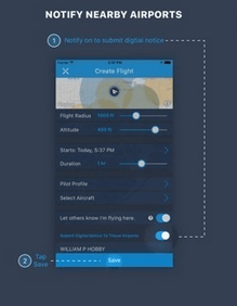
#1.  AirMap.  AirMap provides flight planning intelligence – and real time situational awareness – for pilots.  The app provides information about flight restrictions, both permanent and temporary, as well as changes in the weather.  It also provides real time information about traffic – notifying operators when manned aircraft trajectories cause a likely conflict.  Most interesting, AirMap attempts to solve a huge problem for commercial operators with their Digital Notice and Awareness System™ (D-NAS) which allows operators to communicate with airports to notify them of flight plans.  The system has been implemented by over 125 airports, and is expanding rapidly.

airnest is one of the best apps for phantom users#
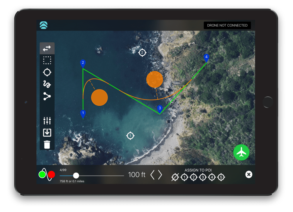
2. Airnest. Airnest offers “simple flight logging and analytics” for drones.  The app has long been a favorite of DJI pilots, but has now moved into the commercial market.  The “Plan” tool offers users the ability to intuitively plan flights; but perhaps more important for commercial pilots is the cloud-based flight logging functionality.  Flight logs that provide useful data on flight metrics including altitude, speed, location, and battery performance allow pros to learn about their drones’ performance and allow quicker diagnosis of potential problems.  The ability to share flight logs with colleagues provides a  boon to both pilots and managers of larger drone operations.

Image courtesy of DroneDeploy

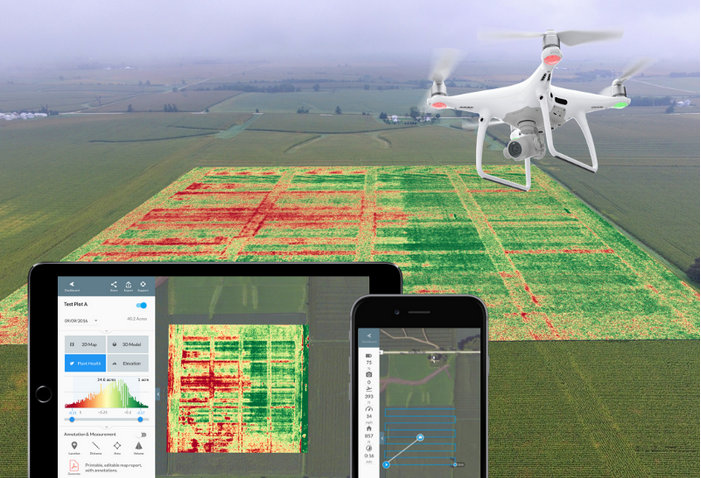
#3. DroneDeploy. DroneDeploy pulls it together for commercial drone operators offering drone mapping for their customers. A world leader in drone mapping platforms, DroneDeploy has established a broad list of partnerships – including integration with Airmap and Airnest, above.   “DroneDeploy simplifies every stage of the drone mapping process—allowing businesses to focus on customers first,” says Mike Winn, DroneDeploy’s CEO.  “Download the DroneDeploy app to plan automated flights, process and analyze imagery, and export maps and models for instant access to aerial insights anywhere, anytime.” This is a professional app that doesn’t just make the operation easier, but helps operators produce a polished, branded deliverable. DroneDeploy is designed to be “part of your day-to-day workflow to drive better business decisions –  and ultimately deliver a more professional product to your customers,” says Winn.

#4. DronePan.  For commercial operators offering photography services, DronePan takes pictures designed to be stitched together into a 360 degree panoramic view.  The app is compatible with DJI Phantom 3, Phantom 4, Inspire 1, Inspire 2 or Mavic Pro drones.  Hit the play button on the app, and DronePan will take 20 photos – in less than 2 minutes – at the necessary yaw and pitch for creating a panoramic view.  The company recommends stitching programs PT Gui and Auto Pano Pro to complete the process.  The app is currently only available for iOS devices but an Android version is currently in Beta.

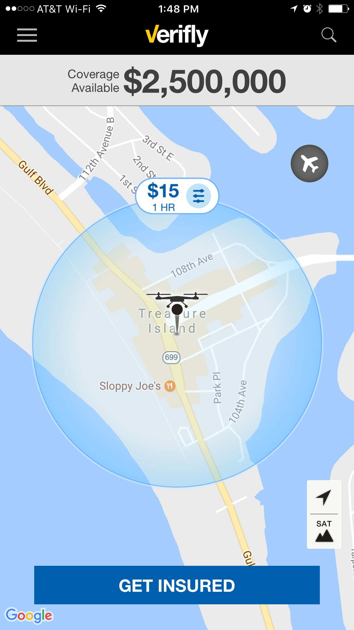
#5. Verifly.  If you haven’t heard of precision insurance yet, you are hearing it now.  In an amazingly short span of time – the company was founded in 2015 – Verifly has become an industry leader in liability insurance for drones, especially in the professional market. “Verifly is the standard for commercial operators who want insurance that works the way they do,” says Verifly CEO, Jay Bregman. “Verifly is both universal and usage-based, and lets them pass on their costs to customers via our unique per-job pricing.”  Download the Verifly app and apply for insurance for your particular job – for only a few hours, or for a longer period of time – at that particular location.  The model allows customers to feel that they are paying only for the liability insurance that their job requires.  Drone operators aren’t paying for liability insurance while they aren’t flying.  The app also allows commercial operators to bypass the hassle of applying for a larger policy with an agent.

As the drone industry expands, the complexity of drone operation – as well as the things that the technology can provide – is also expanding.   These apps, and the many being created every day, are helping operators to increase productivity without increasing the work.


Miriam McNabb

Miriam McNabb is the Editor-in-Chief of DRONELIFE and CEO of JobForDrones, a professional drone services marketplace, and a fascinated observer of the emerging drone industry and the regulatory environment for drones. Miriam has penned over 3,000 articles focused on the commercial drone space and is an international speaker and recognized figure in the industry.  Miriam has a degree from the University of Chicago and over 20 years of experience in high tech sales and marketing for new technologies.
For drone industry consulting or writing, Email Miriam.

TWITTER:@spaldingbarker

Subscribe to DroneLife here.

Filed Under: DL Exclusive, News, Top 5 Tagged With: commercial drone applications, Drone Apps, Drone Deploy, Skyward, Verifly

Reader Interactions

Trackbacks

  1. 5 “Must Have” Apps for Commercial Operators | Icon Aerial Media says:
    March 30, 2017 at 10:22 pm

    […] 5 Drone Apps Every Commercial Operator Should Know […]

    Reply

Leave a Reply Cancel reply

Your email address will not be published. Required fields are marked *

Primary Sidebar

LATEST

National Resilience Strategy Connects the Dots Behind U.S. Drone Policy

New White House strategy frames commercial drones as part of a broader effort to strengthen U.S. manufacturing, infrastructure, and supply…

Continue Reading National Resilience Strategy Connects the Dots Behind U.S. Drone Policy

Beyond the Drone: Percepto’s New Platform Brings AI to Infrastructure Inspections

Percepto launches next-gen inspection software By DRONELIFE Features Editor Jim Magill For energy companies, producing actionable data is almost as…

Continue Reading Beyond the Drone: Percepto’s New Platform Brings AI to Infrastructure Inspections

Danish Investigation Finds No Proof Drones Caused Copenhagen Airport Shutdown

Nine-month investigation underscores the need for better airspace awareness, not just more speculation News and Commentary.  A nine-month investigation into…

Continue Reading Danish Investigation Finds No Proof Drones Caused Copenhagen Airport Shutdown

Flytrex and Wing Report Zero Airspace Conflicts for Multi-Operator Drone Delivery

Flytrex says automated UTM coordination with Wing has deconflicted 100% of operations in Dallas–Fort Worth shared airspace, with zero conflicts.…

Continue Reading Flytrex and Wing Report Zero Airspace Conflicts for Multi-Operator Drone Delivery

BRINC Partnership Gives Public Safety Agencies an “Immediate Upgrade” in Incident Intelligence

BRINC and Nova Partner to Add Advanced Mapping and Thermal Intelligence for Public Safet Public safety drone manufacturer BRINC has…

Continue Reading BRINC Partnership Gives Public Safety Agencies an “Immediate Upgrade” in Incident Intelligence

Prodrone Debuts All-Japanese Industrial Drone

This article published in collaboration with JUIDA, the Japan UAS Industrial Development Association.     Aichi-based Prodrone introduces the PD4B-MS prototype,…

Continue Reading Prodrone Debuts All-Japanese Industrial Drone

Uruguayan Government Announces New Drone Dispatch Program

The Montevideo deployment, run in partnership with Uruguayan technology firm Timerix, ties gunshot-detection alerts to automated drone dispatch and live…

Continue Reading Uruguayan Government Announces New Drone Dispatch Program

Utilities Prepare for BVLOS While Navigating the Post-DJI Transition

Utilities face challenges in establishing drone programs By DRONELIFE Features Editor Jim Magill While the owners of electric utility assets…

Continue Reading Utilities Prepare for BVLOS While Navigating the Post-DJI Transition

FCC Drone Exemption List Offers Clues to Trusted Supplier Requirements

Six months of conditional approvals reveal a broad range of accepted drone applications, while key details of the review process…

Continue Reading FCC Drone Exemption List Offers Clues to Trusted Supplier Requirements

China’s Export Restrictions on Red Cat Highlight a Bigger Challenge for U.S. Drone Manufacturing

Recent Chinese export controls targeting Red Cat may have limited immediate impact, but they underscore why U.S. drone manufacturers are…

Continue Reading China’s Export Restrictions on Red Cat Highlight a Bigger Challenge for U.S. Drone Manufacturing

Secondary Sidebar

Footer

SPONSORED

Inspired Flight Gremsy IF800 VIO F1 drones geo week

What Will It Take to Strengthen U.S. Drone Manufacturing? A Conversation with Inspired Flight’s CEO

Global Mapper Mobile data collection

Collection Ground Control Points with Global Mapper Mobile

Military Drone Mapping Solutions

How SimActive’s Correlator3D™ is Revolutionizing Military Mapping: An Exclusive Interview with CEO Philippe Simard

Photogrammetry Accuracy Standards

SimActive Photogrammetry Software: Enabling Users to Meet Accuracy Standards for Over 20 Years

NACT Engineering Parrot ANAFI tether indoor shot

Smart Tether for Parrot ANAFI USA from NACT Engineering

Blue Marble, features global mapper, features Blue Marble

Check Out These New Features in Global Mapper v25 from Blue Marble

About Us | Contact Us | Advertise With Us | Write for Us | Privacy Policy | Terms of Service

The Trusted Source for the Business of Drones.

This website uses cookies and third party services. By clicking OK, you are agreeing to our privacy policy. ACCEPT

Manage consent

Privacy Overview

This website uses cookies to improve your experience while you navigate through the website. Out of these, the cookies that are categorized as necessary are stored on your browser as they are essential for the working of basic functionalities of the website. We also use third-party cookies that help us analyze and understand how you use this website. These cookies will be stored in your browser only with your consent. You also have the option to opt-out of these cookies. But opting out of some of these cookies may affect your browsing experience.
Necessary
Always Enabled
Necessary cookies are absolutely essential for the website to function properly. These cookies ensure basic functionalities and security features of the website, anonymously.
CookieDurationDescription
cookielawinfo-checkbox-analytics11 monthsThis cookie is set by GDPR Cookie Consent plugin. The cookie is used to store the user consent for the cookies in the category "Analytics".
cookielawinfo-checkbox-functional11 monthsThe cookie is set by GDPR cookie consent to record the user consent for the cookies in the category "Functional".
cookielawinfo-checkbox-necessary11 monthsThis cookie is set by GDPR Cookie Consent plugin. The cookies is used to store the user consent for the cookies in the category "Necessary".
cookielawinfo-checkbox-others11 monthsThis cookie is set by GDPR Cookie Consent plugin. The cookie is used to store the user consent for the cookies in the category "Other.
cookielawinfo-checkbox-performance11 monthsThis cookie is set by GDPR Cookie Consent plugin. The cookie is used to store the user consent for the cookies in the category "Performance".
viewed_cookie_policy11 monthsThe cookie is set by the GDPR Cookie Consent plugin and is used to store whether or not user has consented to the use of cookies. It does not store any personal data.
Functional
Functional cookies help to perform certain functionalities like sharing the content of the website on social media platforms, collect feedbacks, and other third-party features.
Performance
Performance cookies are used to understand and analyze the key performance indexes of the website which helps in delivering a better user experience for the visitors.
Analytics
Analytical cookies are used to understand how visitors interact with the website. These cookies help provide information on metrics the number of visitors, bounce rate, traffic source, etc.
Advertisement
Advertisement cookies are used to provide visitors with relevant ads and marketing campaigns. These cookies track visitors across websites and collect information to provide customized ads.
Others
Other uncategorized cookies are those that are being analyzed and have not been classified into a category as yet.
SAVE & ACCEPT