Guest post by DroneDeploy —
As one ag industry expert put it, using a drone on the farm is like being able to see your field from a 10,000-foot altitude, but also being able to zoom in to two inches above the plants. Growers are increasingly discovering that drone mapping is an invaluable tool, both for its ease of use, and for its many applications on the farm.
“It’s like being able to see your farm from a 10,000-foot altitude, but also being able to zoom in to two inches above the plants. There’s no other system that can do that.” — Rob Eggert, TDS fertilizer.
With the growing season fast approaching, we’ve put together a list of some of the most popular ways growers are using drones to improve their processes and make informed decisions about their crops.
1. Crop Scout to Detect Parasites and Fungi
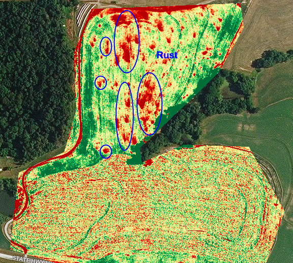
Growers like Brent Gerke are using drone mapping to pinpoint plant health issues such as parasites and fungi. The very first time he used drone mapping software, Brent realized that by switching to the plant health map in his DroneDeploy dashboard, he could see areas of rust fungus in his wheat crop. Clear sections of red coloration on the map enabled him to quickly and easily identify the extent of the rust in the field.
Similarly, Tyler Smith in the Imperial Basin of California uses drone mapping to check alfalfa fields for dodder, a spaghetti-shaped parasitic plant that renders alfalfa seed virtually worthless. The only way to kill dodder is to burn it, so if a grower can catch it early, when the affected area is about the size of a table, they can contain the damage. Spotting such a small patch of dodder is difficult, but DroneDeploy’s plant health map allows growers to do just that.
“If you found a spot [of dodder] as big as the table, you could fix it right away as opposed to having it spread — big savings in terms of the amount of labor it would take to contain it.” — Tyler Smith
2. Compile Plant Counts
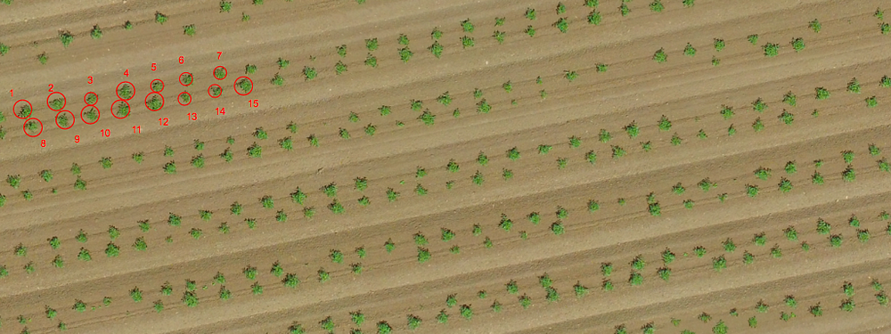
One of the most exciting uses for drone mapping in agriculture is the ability to conduct complete, accurate plant counts. Instead of relying on time-consuming manual counts taken on just a small portion of a field, growers like Toshiro Aoki are using drones to compile automated plant counts of entire fields in a matter of hours.
“The plant counting seals the deal. It saves us the trouble of having to go out and count the whole field.” -agriculture consultant Toshiro Aoki
Toshiro works for a private farm in Northern California. During last year’s growing season, hundreds of thousands of tomatoes plants were transplanted on a 74-acre field by an outside company. Toshiro wanted to make sure the company was billing them only for the established plants, so he used AgriSens, a third-party tool available right within the DroneDeploy dashboard, to quickly and easily get a plant count report that helped him hold the company accountable.
3. Analyze Stand Establishment
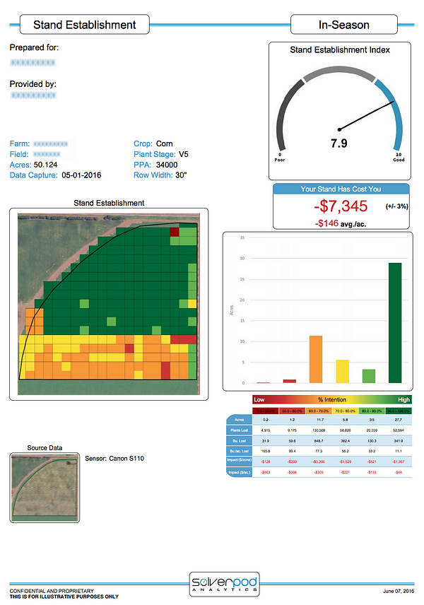
In addition to plant counts, corn and soybean growers are using drone mapping to analyze stand establishment of newly planted crops to decide whether they need to replant certain areas. From the DroneDeploy dashboard, growers can send maps of their emergent fields to ag-focused analytics company Aglytix. The company uses the data to create a report that details crop emergence throughout an entire field, providing a far more comprehensive picture than on-the-ground sampling. The report also includes a stand establishment index and a calculation of the economic loss on the field.
4. Generate Variable Rate Prescriptions for Nitrogen and Pesticides
Ag expert Landon Oldham realizes that drone maps provide him with a rich amount of data that can be used to make more informed decisions about issues like crop reseeding and targeted nutrient applications. Growers can export their drone-generated, zoned shapefiles into Ag industry software to easily generate variable rate prescriptions for nitrogen, pesticides and other applications. He is taking this even one step further.
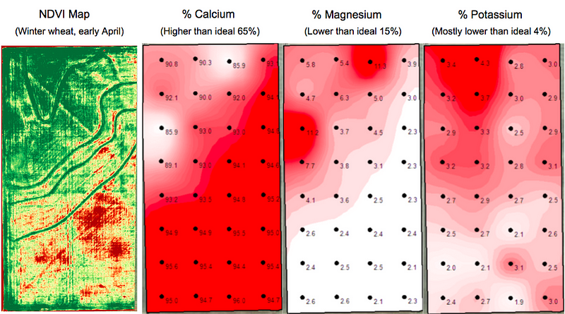
Landon owns Heartland Soil Services, a company that uses soil samples to estimate crop yields and make variable rate prescription maps. He is developing a workflow that combines drone imagery with soil samples to make even more accurate nutrient prescription maps. Instead of relying solely on data from soil samples — about one sample per two acres — Landon’s new workflow combines this sampling with the many data points on a drone-generated NDVI map to gather information at a much more granular level.
“The ROI could be tremendous because growers could further increase the site-specific application of any and all products rather than flat rate applying the entire field at the exact same rate.” — Landon Oldham, Heartland Soil Services
5. Assess and Clean-up Damage After a Storm
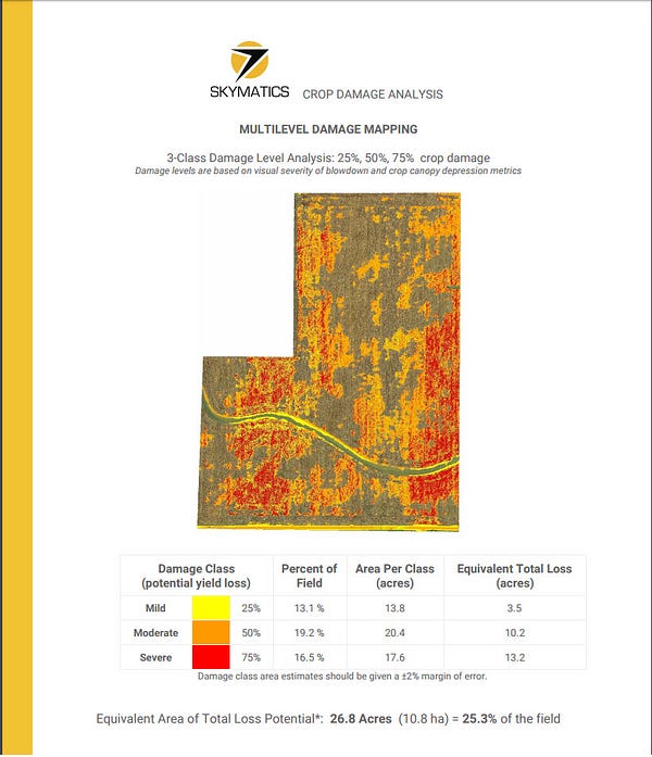
When heavy winds and exceptional rainfall downed corn on a 105-acre field in central Illinois, Jeremy Jones of Overhead Ag used DroneDeploy, paired with a detailed Skymatics report, to help the farmer and seed rep assess the extent of the damage. Instead of relying on traditional ground scouting, which could easily have missed catching large portions of downed crop, Jeremy used his drone to capture a complete picture of the field. Then, with just the click of a few buttons, he generated a detailed Skymatics crop damage report directly from his DroneDeploy dashboard.
The report included a calculation of crop loss and a categorized damage map that gave the farmer and seed rep a far greater understanding of the storm’s damage.
“It’s a nice, polished document that provides way more information on loss than I was getting by measuring certain areas.”- Jeremy Jones of Overhead Ag, on the Skymatics report he generated with his DroneDeploy map
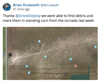
Drone maps can not only help estimate the extent of damage, but in some cases can even help when clean-up is needed. When a tornado tore through his corn and soy fields, tossing debris throughout his crops, Brian Krukewitt made a drone map to spot debris hidden by standing corn and plan to efficiently remove it, whether before or during harvest.
6. Negotiate Fair Crop Loss Percentages
As every grower knows, crop loss is always a possibility — and that’s why many choose to insure their crops. But because insurance adjustors only have time to walk small sections of a damaged field, gaining an accurate picture of the loss can be difficult. This past summer, Gregg Heath of Silicon Falcon Micro Aviation used drone mapping to help a tobacco grower recover a fair loss percentage after heavy rains decimated nearly 100 acres of his crop.
“Drone Deploy is really tailor made for when you are surveying crops,” — Gregg Health of Silicon Falcon Micro Aviation. [click-to-tweet]
Gregg’s annotated crop health map, produced in just a few short hours, convinced an insurance inspector to re-inspect the field after an initial loss estimate fell short of expectations. Thanks to the detailed information provided by Gregg’s drone map, the adjustor took a second look at targeted areas and ultimately offered a far higher loss percentage. The grower ultimately recouped an additional $110,0000 in crop losses.
7. Assess Slope and Drainage After the Harvest
Although this year’s growing season is just beginning, it’s never too early to look ahead. Curt Moore at Agflyers reminds farmers that there are many uses for drone maps even after the harvest. “Once harvest is complete and post-season field prep is complete, you’re essentially left with a blank canvas,” says Curt. “Why not produce a map of your land in this state?”
With crop cover out of the way, Curt suggests using a drone-generated elevation map to get a sense of the slope and drainage of a field. Paired with DroneDeploy’s easy-to-use volume measurement tools, growers can plan the cut and fill of future terraces and waterways.
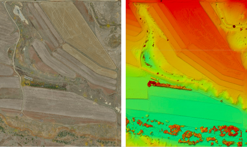
Some growers, like Sam Meeker, take this one step farther, by comparing maps of their drainage systems — in Sam’s case, a map of bare dirt where tile lines are clearly visible — to their yield maps to evaluate the effectiveness of new tiling and decide whether to invest in additional drainage tiles.
Regardless of the crop or region, growers who integrate drones into their work quickly realize that they are easy to use and offer many possibilities. This coming season, growers will continue to use drone mapping to make life on the farm more streamlined, efficient and informed.
Where to Learn More
Thinking about bringing drone mapping to your farm? Be sure to read Seven Common Questions about Drones in Agriculture. For even more tips on using drone mapping in agriculture, check out our webinar, Lessons from the Field, with ag experts Chad Colby and Jim Love.
And as always, take a look at our ag-specific support documentation, such as:
Frank Schroth is editor in chief of DroneLife, the authoritative source for news and analysis on the drone industry: it’s people, products, trends, and events.
Email Frank
TWITTER:@fschroth


[…] Guest post by DroneDeploy — As one ag industry expert put it, using a drone on the farm is like being able to see your field from a 10,000-foot altitude, but also being able to zoom in to two inches above the plants. Growers are increasingly discovering that drone mapping is an invaluable tool, both […] The post Seven Ways to Use Drone Mapping on the Farm This Season appeared first on DRONELIFE. See Original Article […]