• Skip to main content
  • Skip to secondary menu
  • Skip to primary sidebar
  • Skip to secondary sidebar
  • Skip to footer
  • DroneRacingLife
  • DroneFlyers
  • Newsletter
DroneLife

DRONELIFE

Stay up to date on all the latest Drone News

  • News
  • Products
  • Industries
    • Agriculture
    • Construction
    • Delivery
    • Dual Use
    • Inspection
    • Public Safety
    • Surveying
  • Enthusiasts
  • Regulations
  • Business
  • Video
  • Podcasts

Hivemapper’s 3D Earth Maps for Drones App

June 19, 2016 by Alan Phillips 4 Comments

It’s innovative, but will companies embed it for their mission control?

QuickTake

THE FACTS: Last week Hivemapper introduced its 3D earth maps Android app for drones. The preview I received a week earlier was impressive. Hivemapper is a mapping and navigation tool for drone operators to fly more safely and plan missions with awareness of the exact height and 3D footprint of buildings, trees, poles and other structures. Features include:

  • intelligent altitude (drone’s true height above bare earth),
  • an in-flight 3D map with collision avoidance alerts that provides distance to 3D objects,
  • and the ability to do quick object surveys.

The product has been in development since 2015 and was built using the DJI SDK – so it currently works only for DJI Phantoms and Inspire 1 drones.

Hivemapper-01

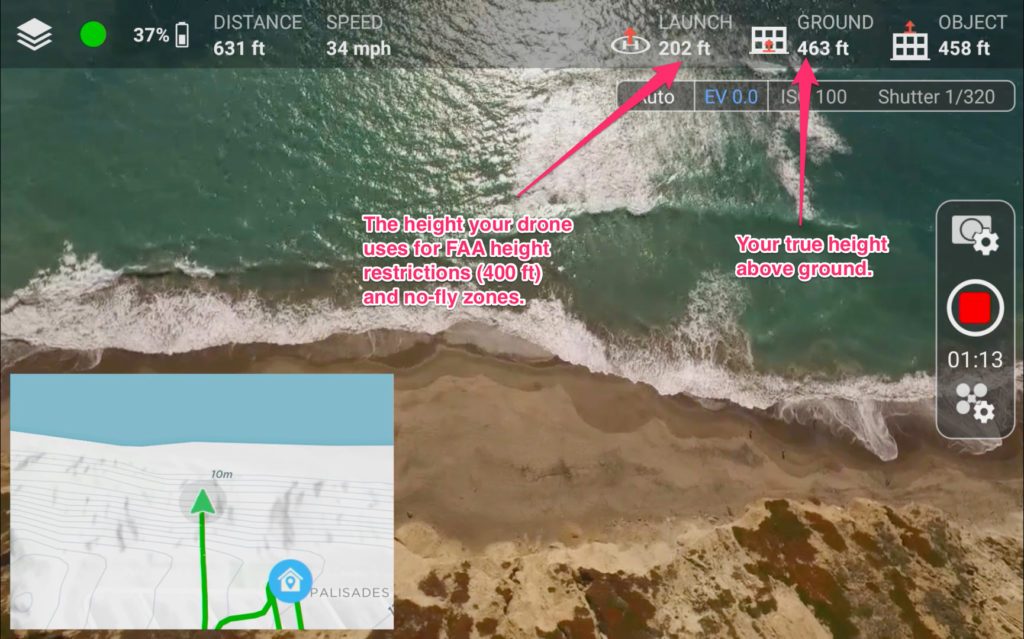
WHAT’S COOL: Product features go way beyond what you find in Google Maps, Google Earth, and intelligent no-fly zone map programs like Airmap or Mapbox. Two things make Hivemapper innovative:

  1. The object point cloud information already contained in their maps—like building, trees, and power line locations and dimensions—boasts centimeter-level accuracy from 6 trillion points with 100% of the US coverage for Intelligent altitude and 60% for 3D objects with more to come.
  2. The second innovation is the ability to collect and add new data from users with an in-app object survey tool. The tool works like a count-down game. As drones circle an object, slices of a pie disappear until none are left. This means the data is complete and can be sent back to crowdsource-update the centralized map for future use.

Other drone app and software developers should make note that Hivemapper has tapped into two very important development techniques: crowdsourcing and gamification. Original data has been captured by existing users’ drones, but ongoing the game design element fosters engagement that supports further data capture.

THE COMPETITION: To be clear, Hivemapper is not alone in their quest to “build a better mouse trap” map for drones. Angel funded Point One Navigation is on a quest to provide a similar ultra-precise location service. But the big question is whether drone mission planning and ground control vendors like 3DR, DroneDeploy, PrecisionHawk, senseFly, UgCS, and even DJI GEO will embed Hivemapper. I believe the use case is compelling. If you don’t understand where a drone is located in all three dimensions then having no-fly zones and 400 foot maximum height limits is pointless in many parts of the U.S. Hivemapper provides those features plus ones the others don’t have—like route planning around objects of unknown height and dimension, route validation, and a much better return home safety route than is provided by simple onboard object avoidance technology.

BOTTOM LINE: Watch this space—the market for maps and apps that give operators awareness of what they could collide – which is heating up. And Hivemapper has a leg up because of their unique and compelling approach with its crowdsourced gamification.

20140718_ColinSnow_0024_1x1_WebColin Snow is CEO and Founder of Skylogic Research, LLC (aka Drone Analyst®), a research, content, and advisory services firm for the commercial drone industry. Colin is a 25-year technology industry veteran with a background in market research, enterprise software, electronics, digital imaging, and mobility.


Alan Phillips
Alan Phillips

Alan is serial entrepreneur, active angel investor, and a drone enthusiast. He co-founded DRONELIFE.com to address the emerging commercial market for drones and drone technology. Prior to DRONELIFE.com, Alan co-founded Where.com, ThinkingScreen Media, and Nurse.com. Recently, Alan has co-founded Crowditz.com,  a leader in Equity Crowdfunding Data, Analytics, and Insights.  Alan can be reached at alan(at)dronelife.com

Filed Under: Applications, Colin Snow, News Tagged With: 3D, DJI GEO, drones, earth map, hivemapper

Reader Interactions

Trackbacks

  1. QuickTake: Hivemapper’s 3D Earth Maps for Drones App | AllDrones.com says:
    July 7, 2016 at 1:04 pm

    […] This post first appeared on Dronelife.com […]

    Reply
  2. Hivemapper’s 3D Earth Maps for Drones App - Drone Analyst says:
    June 22, 2016 at 2:00 pm

    […] This post first appeared on Dronelife.com […]

    Reply
  3. Hivemapper’s 3D Earth Maps for Drones App | AllDrones.com says:
    June 20, 2016 at 8:35 pm

    […] post Hivemapper’s 3D Earth Maps for Drones App appeared first on […]

    Reply
  4. Hivemapper’s 3D Earth Maps for Drones App | Drone, UAV, Quadcopter a Multi Rotor News says:
    June 20, 2016 at 1:00 pm

    […] post Hivemapper’s 3D Earth Maps for Drones App appeared first on […]

    Reply

Leave a Reply Cancel reply

Your email address will not be published. Required fields are marked *

Primary Sidebar

LATEST

If Pilots Stop Trusting Safety Broadcasts, What Happens to Universal Conspicuity?

AOPA’s opposition to ADS-B billing highlights a growing issue for both crewed and uncrewed aviation News and Commentary. A new…

Continue Reading If Pilots Stop Trusting Safety Broadcasts, What Happens to Universal Conspicuity?

The Drone Industry’s Battery Problem Has a New Challenger

Factorial Expands Solid-State Drone Battery Partnerships Across Three Continents New collaborations aim to improve drone endurance, power, and cold-weather performance…

Continue Reading The Drone Industry’s Battery Problem Has a New Challenger

Commercial UAV Expo Releases 2026 Conference Program Focused on “Actionable Insights”

Community feedback shapes event agenda centered on real-world drone operations and practical takeaways Commercial UAV Expo has announced its 2026…

Continue Reading Commercial UAV Expo Releases 2026 Conference Program Focused on “Actionable Insights”

US Drone Makers Are Building a Different Kind of Factory

Additive Manufacturing Helps Build Flexibility, Scale, and Supply Chain Resilience At AUVSI’s XPONENTIAL 2026 conference in Detroit, one theme surfaced…

Continue Reading US Drone Makers Are Building a Different Kind of Factory

Pentagon Backs AI Counter-Drone Startup with $500 Million Deal

JITF 401 signs $500 million contract with fast-growing startup By DRONELIFE Features Editor Jim Magill The Pentagon plans to acquire…

Continue Reading Pentagon Backs AI Counter-Drone Startup with $500 Million Deal

Under the Ice: New SYOS Underwater Drone Targets Maritime Security and Antarctic Exploration

SYOS Introduces SU10 Underwater Drone for Multi-Domain Operations New uncrewed underwater vehicle expands company portfolio from air, land, and sea…

Continue Reading Under the Ice: New SYOS Underwater Drone Targets Maritime Security and Antarctic Exploration

Amprius and Matternet Expand Drone Delivery Battery Partnership

Silicon anode battery technology aims to improve range, charging time, and delivery economics for commercial drone operations Battery manufacturer Amprius…

Continue Reading Amprius and Matternet Expand Drone Delivery Battery Partnership

Kansas City Builds a World Cup-Era Drone Defense Network

Airspace Link and regional public safety agencies deploy a shared drone coordination and counter-UAS platform designed to support FIFA World…

Continue Reading Kansas City Builds a World Cup-Era Drone Defense Network

Autel Challenges FCC Covered List Decision, Distances Itself from DJI

Drone maker argues FCC relied on broad assumptions instead of company-specific analysis In a sharply worded filing with the Federal…

Continue Reading Autel Challenges FCC Covered List Decision, Distances Itself from DJI

Terra Drone Deploys Terra A2 Interceptor Drone to Ukraine Frontlines

The Japanese drone company brings its long-range, wide-area air defense platform into Ukrainian service alongside Terra A1 through a joint…

Continue Reading Terra Drone Deploys Terra A2 Interceptor Drone to Ukraine Frontlines

Secondary Sidebar

Footer

SPONSORED

Inspired Flight Gremsy IF800 VIO F1 drones geo week

What Will It Take to Strengthen U.S. Drone Manufacturing? A Conversation with Inspired Flight’s CEO

Global Mapper Mobile data collection

Collection Ground Control Points with Global Mapper Mobile

Military Drone Mapping Solutions

How SimActive’s Correlator3D™ is Revolutionizing Military Mapping: An Exclusive Interview with CEO Philippe Simard

Photogrammetry Accuracy Standards

SimActive Photogrammetry Software: Enabling Users to Meet Accuracy Standards for Over 20 Years

NACT Engineering Parrot ANAFI tether indoor shot

Smart Tether for Parrot ANAFI USA from NACT Engineering

Blue Marble, features global mapper, features Blue Marble

Check Out These New Features in Global Mapper v25 from Blue Marble

About Us | Contact Us | Advertise With Us | Write for Us | Privacy Policy | Terms of Service

The Trusted Source for the Business of Drones.

This website uses cookies and third party services. By clicking OK, you are agreeing to our privacy policy. ACCEPT

Manage consent

Privacy Overview

This website uses cookies to improve your experience while you navigate through the website. Out of these, the cookies that are categorized as necessary are stored on your browser as they are essential for the working of basic functionalities of the website. We also use third-party cookies that help us analyze and understand how you use this website. These cookies will be stored in your browser only with your consent. You also have the option to opt-out of these cookies. But opting out of some of these cookies may affect your browsing experience.
Necessary
Always Enabled
Necessary cookies are absolutely essential for the website to function properly. These cookies ensure basic functionalities and security features of the website, anonymously.
CookieDurationDescription
cookielawinfo-checkbox-analytics11 monthsThis cookie is set by GDPR Cookie Consent plugin. The cookie is used to store the user consent for the cookies in the category "Analytics".
cookielawinfo-checkbox-functional11 monthsThe cookie is set by GDPR cookie consent to record the user consent for the cookies in the category "Functional".
cookielawinfo-checkbox-necessary11 monthsThis cookie is set by GDPR Cookie Consent plugin. The cookies is used to store the user consent for the cookies in the category "Necessary".
cookielawinfo-checkbox-others11 monthsThis cookie is set by GDPR Cookie Consent plugin. The cookie is used to store the user consent for the cookies in the category "Other.
cookielawinfo-checkbox-performance11 monthsThis cookie is set by GDPR Cookie Consent plugin. The cookie is used to store the user consent for the cookies in the category "Performance".
viewed_cookie_policy11 monthsThe cookie is set by the GDPR Cookie Consent plugin and is used to store whether or not user has consented to the use of cookies. It does not store any personal data.
Functional
Functional cookies help to perform certain functionalities like sharing the content of the website on social media platforms, collect feedbacks, and other third-party features.
Performance
Performance cookies are used to understand and analyze the key performance indexes of the website which helps in delivering a better user experience for the visitors.
Analytics
Analytical cookies are used to understand how visitors interact with the website. These cookies help provide information on metrics the number of visitors, bounce rate, traffic source, etc.
Advertisement
Advertisement cookies are used to provide visitors with relevant ads and marketing campaigns. These cookies track visitors across websites and collect information to provide customized ads.
Others
Other uncategorized cookies are those that are being analyzed and have not been classified into a category as yet.
SAVE & ACCEPT