
• Skip to main content
  • Skip to secondary menu
  • Skip to primary sidebar
  • Skip to secondary sidebar
  • Skip to footer
  • DroneRacingLife
  • DroneFlyers
  • Newsletter
DroneLife

DRONELIFE

Stay up to date on all the latest Drone News

  • News
  • Products
  • Industries
    • Agriculture
    • Construction
    • Delivery
    • Dual Use
    • Inspection
    • Public Safety
    • Surveying
  • Enthusiasts
  • Regulations
  • Business
  • Video
  • Podcasts

Airnest Launches ‘Plan’ – The Photoshop of Flight Planning

May 13, 2016 by Malek Murison 2 Comments

Flight app Airnest has released a new update, with a number of original features designed to make complex, precision flight plans easy to put together. The original Airnest app has become well known for its simplicity and ease of use, and now the team behind Airnest 2.0 hopes to offer more sophisticated flight planning without losing any of its intuitive feel.

Game-changing features

New and current Airnest users will find several new tools and features within ‘Plan’:

  • Create up to 5 points of interest
  • Clean up your shots with automatic and smooth camera transition between POIs
  • Say goodbye to abrupt changes in direction, with waypoint curves that can now be adjusted with a simple dragging gesture
  • Set altitudes for both waypoints and points of interest
  • Tap to add waypoints or draw your flight path
  • Save your flight plans and make adjustments later
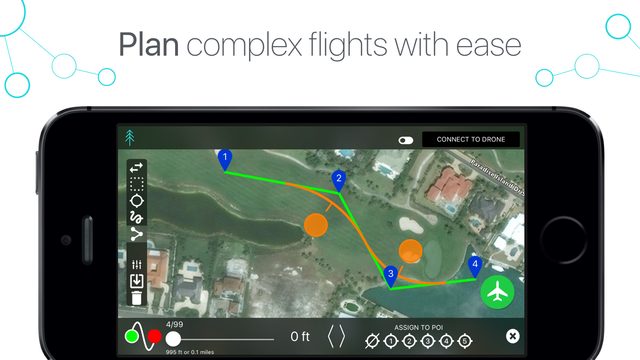
Airnest 2.0 plan tool

The Photoshop of Flight Planning

While many will appreciate the precision planning and thoroughness now offered by Airnest 2.0, arguably its biggest selling point is still its ease of use. In part this is driven by a tidy, intuitive user interface. But the usability benefits hugely from various concepts inspired by photoshop. Users can simply draw a flight path with a swipe of a finger, tap to add waypoints, use a lasso tool to select a group of waypoints, and easily adjust a corner radius just by dragging.

I spoke with the team behind Airnest to dig a little deeper into the app and the inspiration behind it. Co-founder and CEO Ben Brautigam suggested that simplicity was always at the forefront when developing the new ‘Plan’ tool. “We obsessively think about how to make complex processes and features as natural as possible,” he said. “An example is setting a corner radius on a waypoint. Rather than sort through multiple menus and sliders, in Airnest you simply drag the curve with your finger – Why should it be any other way?  We refuse to sacrifice ease of use for capability and precision. They should work in tandem.”

“Plan combines precise, detailed flight planning with a simple and clean design. The addition of Plan makes Airnest the complete solution for every drone pilot.”  – Ben Brautigam, co-founder & CEO, Airnest

One of the criticisms that could have been levelled at Airnest in the past is that its competitors offer higher levels of precision within the flight planning process. Not long ago we highlighted this in our top 5 apps article. The likes of Autopilot and Litchie did offer a significantly higher level of detail. But Airnest 2.0 does a lot to close the gap, without sacrificing the user friendliness that made it popular in the first place. We believe Airnest plays a critical role in the software landscape,” said Brautigam. “Precise flight planning without complication. We want to focus on the art of crafting a drone flight, and the tools to do that should be simple, well-designed, and straightforward.”

Airnest Maintain Philosophy of Simplicity

The aim of Airnest 2.0 is to improve the flight planning process and widen the app’s base of users to include professional pilots. Co-founder Justin Miller has a background in photography and film, so is well placed to understand the industry’s needs. “When I went to film school and then later worked as a filmmaker, the technology was vastly different than it is today and was changing constantly,” he said. “But there is one tenant about filmmaking that never changes: storytelling. At the end of the day, all of this great technology exists so that we can tell a really great and compelling story. Everything within Airnest, both now and features coming in the future, is designed to support that philosophy.”

Airnest 2.0 – Beta Testers Feedback

Airnest have provided us with some feedback from beta testers. If you’d like to try the app out for yourself, download it from iTunes, here.

“Features that competing apps haven’t even thought of yet. Well-engineered.” – Marc Hufnagel

“The simplest way to get a head start on smooth drone flying! I like the ability to edit multiple waypoints at once, and how simple it is to get graceful, sweeping shots.” – jdmbaldwin

“I like the ability to plan routes ahead of time and then be able to modify them after seeing the FPV and saving them. This is very helpful. As flights become more complicated, being able to have the basic plan worked out ahead of time and make quick modifications when time is of the essences (i.e. dusk or dawn shots and losing light) is key” – Mike Meleski

Malek Murison
Malek Murison

Malek Murison is a freelance writer and editor with a passion for tech trends and innovation. He handles product reviews, major releases and keeps an eye on the enthusiast market for DroneLife.
Email Malek
Twitter:@malekmurison

Subscribe to DroneLife here.

Filed Under: Before You Buy, DL Exclusive, Enthusiasts, Featured - Enthusiasts, Media, News, Products Tagged With: Airnest, app, flight planning, photoshop, Plan, Update

Reader Interactions

Comments

  1. Willem says

    May 16, 2016 at 5:15 am

    Would like to know if it will work with the dji f550 drone

    Reply
    • Malek Murison says

      May 16, 2016 at 9:50 am

      Hi Willem,

      I don’t think so. For a list of compatible devices you can visit http://www.airnest.com/

      Malek

      Reply

Leave a Reply Cancel reply

Your email address will not be published. Required fields are marked *

Primary Sidebar

LATEST

White House Imposes New Tariffs on Imported Drones and Components

Section 232 action sets tariffs of 25% to 100%, with lower rates for qualifying allied supply chains and incentives for…

Continue Reading White House Imposes New Tariffs on Imported Drones and Components

Pennsylvania National Guard Becomes Hub for Pentagon’s Drone Dominance Program

Fort Indiantown Gap trains soldiers on new military drones while developing hands-on counter-UAS tactics By DRONELIFE Features Editor Jim Magill…

Continue Reading Pennsylvania National Guard Becomes Hub for Pentagon’s Drone Dominance Program

Powerful Public Safety Technology Needs Powerful Guardrails: What Flock’s Camera Controversy Means for Drones

Recent cases involving misuse of automated license plate readers offer a broader lesson for public safety agencies adopting increasingly capable…

Continue Reading Powerful Public Safety Technology Needs Powerful Guardrails: What Flock’s Camera Controversy Means for Drones

Engineering Without Compromise: How HP Additive Manufacturing Helped EIVIE Build an NDAA-Compliant Drone

For one startup drone manufacturer, additive manufacturing made it possible to preserve an ambitious aerodynamic design while adapting quickly to…

Continue Reading Engineering Without Compromise: How HP Additive Manufacturing Helped EIVIE Build an NDAA-Compliant Drone

Two Shenzhen Rivals, Two Different Paths to the U.S. Market

As Insta360 expands across cameras and drones, restrictions on DJI could create an opening for its increasingly direct Chinese competitor.…

Continue Reading Two Shenzhen Rivals, Two Different Paths to the U.S. Market

SimActive Correlator3D Supports Large-Scale Green Hydrogen Mapping in Chile

Geo4D used the photogrammetry platform to process high-resolution aerial imagery covering more than 100,000 hectares in Patagonia. SimActive’s Correlator3D photogrammetry…

Continue Reading SimActive Correlator3D Supports Large-Scale Green Hydrogen Mapping in Chile

Michigan Drone Lawsuit Challenges Restrictions on Flights Near Police Operations

Michigan man sues sheriff’s department over state’s drone law By DRONELIFE Features Editor Jim Magill A Michigan-based freelance journalist has…

Continue Reading Michigan Drone Lawsuit Challenges Restrictions on Flights Near Police Operations

Michigan Awards $2 Million for Five Advanced Air Mobility Projects

State agencies will test drones and aerial technologies for environmental monitoring, wildfire response, infrastructure, public safety and agriculture. Michigan has…

Continue Reading Michigan Awards $2 Million for Five Advanced Air Mobility Projects

FCC Revokes Drone Approvals After U.S. Assembler Denies Any Connection

Odyssey Robot claimed its equipment was made and assembled in the U.S.; an FCC investigation found otherwis The Federal Communications…

Continue Reading FCC Revokes Drone Approvals After U.S. Assembler Denies Any Connection

FlybyOps Launches Enterprise Platform for Scaling BVLOS and Autonomous Drone Operations

Finland-based platform aims to help operators manage compliance, risk and operational oversight as drone programs grow in size and complexity…

Continue Reading FlybyOps Launches Enterprise Platform for Scaling BVLOS and Autonomous Drone Operations

Secondary Sidebar

Footer

SPONSORED

Inspired Flight Gremsy IF800 VIO F1 drones geo week

What Will It Take to Strengthen U.S. Drone Manufacturing? A Conversation with Inspired Flight’s CEO

Global Mapper Mobile data collection

Collection Ground Control Points with Global Mapper Mobile

Military Drone Mapping Solutions

How SimActive’s Correlator3D™ is Revolutionizing Military Mapping: An Exclusive Interview with CEO Philippe Simard

Photogrammetry Accuracy Standards

SimActive Photogrammetry Software: Enabling Users to Meet Accuracy Standards for Over 20 Years

NACT Engineering Parrot ANAFI tether indoor shot

Smart Tether for Parrot ANAFI USA from NACT Engineering

Blue Marble, features global mapper, features Blue Marble

Check Out These New Features in Global Mapper v25 from Blue Marble

About Us | Contact Us | Advertise With Us | Write for Us | Privacy Policy | Terms of Service

The Trusted Source for the Business of Drones.

This website uses cookies and third party services. By clicking OK, you are agreeing to our privacy policy. ACCEPT

Manage consent

Privacy Overview

This website uses cookies to improve your experience while you navigate through the website. Out of these, the cookies that are categorized as necessary are stored on your browser as they are essential for the working of basic functionalities of the website. We also use third-party cookies that help us analyze and understand how you use this website. These cookies will be stored in your browser only with your consent. You also have the option to opt-out of these cookies. But opting out of some of these cookies may affect your browsing experience.
Necessary
Always Enabled
Necessary cookies are absolutely essential for the website to function properly. These cookies ensure basic functionalities and security features of the website, anonymously.
CookieDurationDescription
cookielawinfo-checkbox-analytics11 monthsThis cookie is set by GDPR Cookie Consent plugin. The cookie is used to store the user consent for the cookies in the category "Analytics".
cookielawinfo-checkbox-functional11 monthsThe cookie is set by GDPR cookie consent to record the user consent for the cookies in the category "Functional".
cookielawinfo-checkbox-necessary11 monthsThis cookie is set by GDPR Cookie Consent plugin. The cookies is used to store the user consent for the cookies in the category "Necessary".
cookielawinfo-checkbox-others11 monthsThis cookie is set by GDPR Cookie Consent plugin. The cookie is used to store the user consent for the cookies in the category "Other.
cookielawinfo-checkbox-performance11 monthsThis cookie is set by GDPR Cookie Consent plugin. The cookie is used to store the user consent for the cookies in the category "Performance".
viewed_cookie_policy11 monthsThe cookie is set by the GDPR Cookie Consent plugin and is used to store whether or not user has consented to the use of cookies. It does not store any personal data.
Functional
Functional cookies help to perform certain functionalities like sharing the content of the website on social media platforms, collect feedbacks, and other third-party features.
Performance
Performance cookies are used to understand and analyze the key performance indexes of the website which helps in delivering a better user experience for the visitors.
Analytics
Analytical cookies are used to understand how visitors interact with the website. These cookies help provide information on metrics the number of visitors, bounce rate, traffic source, etc.
Advertisement
Advertisement cookies are used to provide visitors with relevant ads and marketing campaigns. These cookies track visitors across websites and collect information to provide customized ads.
Others
Other uncategorized cookies are those that are being analyzed and have not been classified into a category as yet.
SAVE & ACCEPT




