• Skip to main content
  • Skip to secondary menu
  • Skip to primary sidebar
  • Skip to secondary sidebar
  • Skip to footer
  • DroneRacingLife
  • DroneFlyers
  • Newsletter
DroneLife

DRONELIFE

Stay up to date on all the latest Drone News

  • News
  • Products
  • Industries
    • Agriculture
    • Construction
    • Delivery
    • Dual Use
    • Inspection
    • Public Safety
    • Surveying
  • Enthusiasts
  • Regulations
  • Business
  • Video
  • Podcasts

Microsoft’s Police Car to Include Drones

October 28, 2015 by Miriam McNabb 10 Comments

Microsoft's MAPP car
Microsoft’s MAPP car

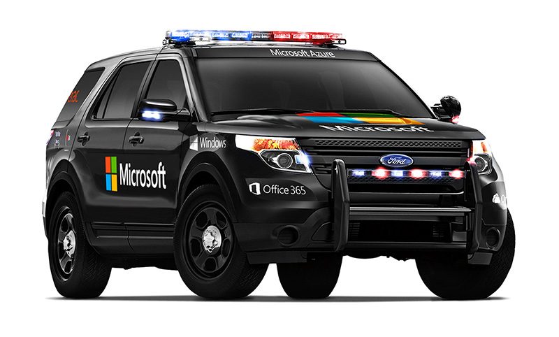
Reminiscent of KITT from the 1980’s TV series “Knight Rider,” Microsoft’s Advanced Patrol Platform (MAPP) car has it all – drone included.  The MAPP car is designed to provide police officers with all of the information that they need in one elegant interface, built into a patrol car and accessible on an officer’s mobile device.  The list of information available to police personnel through the interface is formidable: the system includes dispatch communications, driving directions, suspect histories, a voice-activated license plate reader, a missing persons list, location-based crime bulletins, and shift reports.

Now, Microsoft announced yesterday, it will include an Aeryon Labs drone to provide aerial imagery.  Canadian drone manufacturer Aeryon Labs will provide its SkyRanger™ drone to the MAPP cars, which will provide aerial views to the integrated data platform, allowing officers to assess ongoing situations in real time, or to gather forensic evidence from a crime scene.

Aeryon Labs SkyRanger

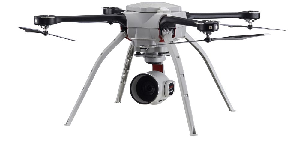
The SkyRanger is a vertical takeoff and landing drone, with a 50 minute flight time.  The product description states that it offers single-operator transport and deployment, and is ideal for government and commercial use due to its stability in high winds and adverse conditions.

“Law enforcement organizations throughout the world rely on Aeryon sUAS to collect aerial intelligence wherever and whenever they need it,” said Dave Kroetsch, president and CEO of Aeryon Labs Inc. “Including SkyRanger within the MAPP vehicle rounds out the comprehensive suite of technologies and highlights the value of aerial intelligence for ground-based personnel.”

Microsoft introduced the MAPP vehicle last July at the FBI National Academy Associates Conference.

Miriam McNabb

Miriam McNabb is the Editor-in-Chief of DRONELIFE and CEO of JobForDrones, a professional drone services marketplace, and a fascinated observer of the emerging drone industry and the regulatory environment for drones. Miriam has penned over 3,000 articles focused on the commercial drone space and is an international speaker and recognized figure in the industry.  Miriam has a degree from the University of Chicago and over 20 years of experience in high tech sales and marketing for new technologies.
For drone industry consulting or writing, Email Miriam.

TWITTER:@spaldingbarker

Subscribe to DroneLife here.

Filed Under: News, Selected – Safety and Security Tagged With: Aeryon Labs, MAPP, Microsoft, Police

Reader Interactions

Comments

  1. Apollo says

    April 25, 2016 at 9:09 am

    Since there are only a handfull of police departments in the country who have authorization to have an aviation unit and have completed their civil COA. This company has NOT serviced departments in the US other than the Michigan State Police.

    Reply

Trackbacks

  1. The Microsoft Police State: Mass Surveillance, Facial Recognition, and the Azure Cloud – RADFUNDS says:
    August 6, 2020 at 10:05 am

    […] “follow it around and see a bigger view of it.” The drones, writes DroneLife, can “provide aerial views to the integrated data platform, allowing officers to assess ongoing situations in real time, or to […]

    Reply
  2. An overview of Microsoft's various services for law enforcement, including the Domain Awareness System, a mass surveillance platform it first built for the NYPD (Michael Kwet/The Intercept) – CityInsidernews says:
    July 17, 2020 at 7:02 am

    […] it around and see a bigger view of it.” The drones, writes DroneLife, can “provide aerial views to the integrated data platform, allowing officers to assess ongoing situations in real time, or to […]

    Reply
  3. The Microsoft Police State: Mass Surveillance, Facial Recognition, and the Azure Cloud says:
    July 15, 2020 at 8:44 am

    […] drones “follow it around and see a bigger view of it.” The drones, writes DroneLife, can “provide aerial views to the integrated data platform, allowing officers to assess ongoing situations in real time, or to […]

    Reply
  4. The Microsoft Police State: Mass Surveillance, Facial Recognition, and the Azure Cloud – 5K Marketing says:
    July 15, 2020 at 4:32 am

    […] drones “follow it around and see a bigger view of it.” The drones, writes DroneLife, can “provide aerial views to the integrated data platform, allowing officers to assess ongoing situations in real time, or to […]

    Reply
  5. The Microsoft Police State: Mass Surveillance, Facial Recognition, and the Azure Cloud - G20 Intel says:
    July 14, 2020 at 4:12 pm

    […] it around and see a bigger view of it.” The drones, writes DroneLife, can “provide aerial views to the integrated data platform, allowing officers to assess ongoing situations in real time, or to […]

    Reply
  6. FLIR, 200 Milyon Dolarlık Bir Anlaşma ile Aeryon Drone Şirketinin sahibi oldu – Drone Haber says:
    March 6, 2019 at 1:44 pm

    […] eyalet çapındaki görevler için  Michigan Eyalet polisi tarafından Microsoft’un Geliştirilmiş Devriye Arabası’nın bir parçası haline getirildi. Aeryon Labs. FLIR yönetimi ve Savunma İşleri Birimi […]

    Reply
  7. FLIR Acquires Aeryon Drone Company in $200 Million Deal – UAV – DRONEENEWS.COM says:
    January 31, 2019 at 4:40 pm

    […] In fact, police agencies have already used SkyRanger to locate missing persons in Canada and North Carolina. The SkyRanger is also the standardized, statewide go-to for the Michigan State Police as well as a key part of Microsoft’s Advanced Patrol Platform car. […]

    Reply
  8. Police Car to Include Drones | UAV Expert News says:
    March 8, 2017 at 11:47 am

    […] Source: DroneLife.com […]

    Reply
  9. Drones, Microsoft Help Fly Police Data Into the Cloud - DFW FlyBy PhotograpghyDFW FlyBy Photograpghy | Drone Services & Aerial Cinematography – FAA Approved says:
    October 17, 2016 at 4:54 pm

    […] of real-time video surveillance devices and streaming body cameras, Microsoft highlighted the Microsoft Advanced Patrol Platform, a smart patrol car which debuted at last year’s IACP expo. Drones that enhance police […]

    Reply

Leave a Reply Cancel reply

Your email address will not be published. Required fields are marked *

Primary Sidebar

LATEST

Conroe Police Launch DFR Program Funded by Criminal Asset Seizures

City’s DFR program financed by asset forfeiture funds By DRONELIFE Features Editor Jim Magill Images: Jim Magill When the city…

Continue Reading Conroe Police Launch DFR Program Funded by Criminal Asset Seizures

IACLEA Launches National Campus Drone Program with Draganfly

New initiative offers colleges a framework for building compliant drone programs focused on public safety, training, and governance The International…

Continue Reading IACLEA Launches National Campus Drone Program with Draganfly

Beyond the Numbers: What 300 World Cup Drone Seizures Really Tell Us

The headline is hard to miss: more than 300 drones have been seized near FIFA World Cup venues since the…

Continue Reading Beyond the Numbers: What 300 World Cup Drone Seizures Really Tell Us

Who Builds the Sky? How Regional Partnerships Are Creating the Infrastructure for Advanced Air Mobility

On this episode of the Drone Radio Show, Lavera Alexander of the Monterey Bay Economic Partnership discusses why the future…

Continue Reading Who Builds the Sky? How Regional Partnerships Are Creating the Infrastructure for Advanced Air Mobility

FAA Moves from Planning to Building for Advanced Air Mobility

New research facility signals shift from policy development to operational readiness The Federal Aviation Administration is taking another step toward…

Continue Reading FAA Moves from Planning to Building for Advanced Air Mobility

How Skyways Quietly Built a Global Heavy-Lift Drone Business

Texas-based company expands offshore cargo operations while preparing for the next phase of U.S. BVLOS regulations By DRONELIFE Features Editor…

Continue Reading How Skyways Quietly Built a Global Heavy-Lift Drone Business

National Resilience Strategy Connects the Dots Behind U.S. Drone Policy

New White House strategy frames commercial drones as part of a broader effort to strengthen U.S. manufacturing, infrastructure, and supply…

Continue Reading National Resilience Strategy Connects the Dots Behind U.S. Drone Policy

Beyond the Drone: Percepto’s New Platform Brings AI to Infrastructure Inspections

Percepto launches next-gen inspection software By DRONELIFE Features Editor Jim Magill For energy companies, producing actionable data is almost as…

Continue Reading Beyond the Drone: Percepto’s New Platform Brings AI to Infrastructure Inspections

Danish Investigation Finds No Proof Drones Caused Copenhagen Airport Shutdown

Nine-month investigation underscores the need for better airspace awareness, not just more speculation News and Commentary.  A nine-month investigation into…

Continue Reading Danish Investigation Finds No Proof Drones Caused Copenhagen Airport Shutdown

Flytrex and Wing Report Zero Airspace Conflicts for Multi-Operator Drone Delivery

Flytrex says automated UTM coordination with Wing has deconflicted 100% of operations in Dallas–Fort Worth shared airspace, with zero conflicts.…

Continue Reading Flytrex and Wing Report Zero Airspace Conflicts for Multi-Operator Drone Delivery

Secondary Sidebar

Footer

SPONSORED

Inspired Flight Gremsy IF800 VIO F1 drones geo week

What Will It Take to Strengthen U.S. Drone Manufacturing? A Conversation with Inspired Flight’s CEO

Global Mapper Mobile data collection

Collection Ground Control Points with Global Mapper Mobile

Military Drone Mapping Solutions

How SimActive’s Correlator3D™ is Revolutionizing Military Mapping: An Exclusive Interview with CEO Philippe Simard

Photogrammetry Accuracy Standards

SimActive Photogrammetry Software: Enabling Users to Meet Accuracy Standards for Over 20 Years

NACT Engineering Parrot ANAFI tether indoor shot

Smart Tether for Parrot ANAFI USA from NACT Engineering

Blue Marble, features global mapper, features Blue Marble

Check Out These New Features in Global Mapper v25 from Blue Marble

About Us | Contact Us | Advertise With Us | Write for Us | Privacy Policy | Terms of Service

The Trusted Source for the Business of Drones.

This website uses cookies and third party services. By clicking OK, you are agreeing to our privacy policy. ACCEPT

Manage consent

Privacy Overview

This website uses cookies to improve your experience while you navigate through the website. Out of these, the cookies that are categorized as necessary are stored on your browser as they are essential for the working of basic functionalities of the website. We also use third-party cookies that help us analyze and understand how you use this website. These cookies will be stored in your browser only with your consent. You also have the option to opt-out of these cookies. But opting out of some of these cookies may affect your browsing experience.
Necessary
Always Enabled
Necessary cookies are absolutely essential for the website to function properly. These cookies ensure basic functionalities and security features of the website, anonymously.
CookieDurationDescription
cookielawinfo-checkbox-analytics11 monthsThis cookie is set by GDPR Cookie Consent plugin. The cookie is used to store the user consent for the cookies in the category "Analytics".
cookielawinfo-checkbox-functional11 monthsThe cookie is set by GDPR cookie consent to record the user consent for the cookies in the category "Functional".
cookielawinfo-checkbox-necessary11 monthsThis cookie is set by GDPR Cookie Consent plugin. The cookies is used to store the user consent for the cookies in the category "Necessary".
cookielawinfo-checkbox-others11 monthsThis cookie is set by GDPR Cookie Consent plugin. The cookie is used to store the user consent for the cookies in the category "Other.
cookielawinfo-checkbox-performance11 monthsThis cookie is set by GDPR Cookie Consent plugin. The cookie is used to store the user consent for the cookies in the category "Performance".
viewed_cookie_policy11 monthsThe cookie is set by the GDPR Cookie Consent plugin and is used to store whether or not user has consented to the use of cookies. It does not store any personal data.
Functional
Functional cookies help to perform certain functionalities like sharing the content of the website on social media platforms, collect feedbacks, and other third-party features.
Performance
Performance cookies are used to understand and analyze the key performance indexes of the website which helps in delivering a better user experience for the visitors.
Analytics
Analytical cookies are used to understand how visitors interact with the website. These cookies help provide information on metrics the number of visitors, bounce rate, traffic source, etc.
Advertisement
Advertisement cookies are used to provide visitors with relevant ads and marketing campaigns. These cookies track visitors across websites and collect information to provide customized ads.
Others
Other uncategorized cookies are those that are being analyzed and have not been classified into a category as yet.
SAVE & ACCEPT