
SimActive Inc. is a world-leading developer of photogrammetry software - for drones and for manned aircraft. It's a professional tool that provides the speed and precision big business expects. SimActive’s Correlator 3D software takes data from any sensor and uses one software interface for processing. Now, SimActive introduces new features to improve volumetric … [Read more...] about SimActive for Mining: Drones and Volume Calculation
SimActive
Headed to InterDrone? Here are Some Booths You Shouldn’t Miss.
InterDrone - held Sept. 5-7 in Las Vegas this year -is getting close. There is so much to see and learn at the biggest commercial drone event in North America that planning is a good idea. We surveyed our partners to see what they were offering this year - here's a list of booths and events that you won't want to miss. ANRA Technologies, Booth 206 ANRA provides … [Read more...] about Headed to InterDrone? Here are Some Booths You Shouldn’t Miss.
Mapping from a Drone vs. Mapping from Manned Aircraft or Satellite Data: The Difference is Getting Smaller All the Time with SimActive
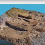
Creating 3D models and maps from aerial footage isn't a new idea. Sophisticated, survey grade models from satellite and aircraft images have been used for large scale environmental surveys, construction projects, and other applications. That functionality is incredibly valuable - and until recently, reserved for government and large industry due to the expense. Drones, … [Read more...] about Mapping from a Drone vs. Mapping from Manned Aircraft or Satellite Data: The Difference is Getting Smaller All the Time with SimActive
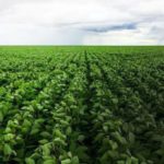
Drones and Centipedes: Brazilian Farmers Adopt Precision Agriculture with SimActive
Brazilian farmers are adopting drone technology through a new partnership between SimActive Inc., a world-leader in photogrammetry, and precision agriculture services provider Portal Produtos Agropecuários Ltda (Portal). Portal develops projects in northern Brazil to serve farmers with aerial mapping over agricultural areas, together with high level technical and agronomic … [Read more...] about Drones and Centipedes: Brazilian Farmers Adopt Precision Agriculture with SimActive
SimActive Announces Improved Workflow for DJI Users in Surveying and Construction
SimActive Inc., a world-leading developer of photogrammetry software, is announced an improved workflow for DJI users. The company tells us that hours of processing time per project are now saved, with volume measurement, pre-construction planning, land development, and other applications streamlined. Butler & Associates Inc., a professional surveying firm with over 35 … [Read more...] about SimActive Announces Improved Workflow for DJI Users in Surveying and Construction


