AgEagle Aerial Systems Inc. (NYSE: UAVS), operating as EagleNXT, has completed the sale of six eBee TAC tactical mapping drones to the U.S. Army, each equipped with premium S.O.D.A. 3D and Duet M sensors featuring full RTK/PPK activation. The transaction was facilitated through commercial partner Dronivo GmbH in Germany and represents a landmark procurement for advanced aerial … [Read more...] about EagleNXT Announces Sale of eBee TAC Mapping Drones to US Army
NDAA Compliant
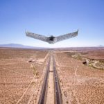
New GNSS Receiver Platform Boosts Mapping Accuracy and Efficiency: a Case Study

InTerra SmarTarget® streamlines high-precision workflows for commercial drone mappers Accuracy is critical in geospatial work. Drone operators also need systems that save time in the field and in the office. The InTerra SmarTarget® platform aims to deliver both. One commercial drone mapping provider in Nashville, reports major gains after adding the system to its … [Read more...] about New GNSS Receiver Platform Boosts Mapping Accuracy and Efficiency: a Case Study
Versaterm Partners with Vantage Robotics to Integrate Blue UAS for Public Safety Operations

At IACP 2025, Ottawa-based Versaterm announced a new partnership with Californian company Vantage Robotics to integrate the Vesper and Trace UAVs into its public safety platform. The collaboration expands Versaterm’s secure, National Defense Authorization Act (NDAA)-compliant portfolio of Blue UAS cleared and U.S.-manufactured drones. “Our mission is to provide first … [Read more...] about Versaterm Partners with Vantage Robotics to Integrate Blue UAS for Public Safety Operations
From the Floor Of Intergeo 2025: GeoCue Announces NDAA-Compliant TrueView 641 Aerial LiDAR Sensor

GeoCue unveiled the TrueView 641 at INTERGEO 2025, a new NDAA-compliant aerial LiDAR sensor designed to meet growing demand from surveying and engineering companies across the United States and worldwide. The engineering-grade sensor addresses the increasing number of Federal, State, Local, and Educational contracts requiring NDAA compliance while maintaining cost accessibility … [Read more...] about From the Floor Of Intergeo 2025: GeoCue Announces NDAA-Compliant TrueView 641 Aerial LiDAR Sensor
From the Floor of Intergeo 2025: Xer Showcases Their Hybrid-Electric X8 Infrastructure Inspection Drone

Swiss manufacturer Xer Technologies presented its Xer X8 hybrid-electric unmanned aircraft system at Intergeo 2025 in Frankfurt, demonstrating the platform's advanced capabilities for large-scale infrastructure monitoring operations. The Xer X8 addresses critical operational limitations of battery-powered drones through innovative hybrid propulsion technology. Xer X8 Technical … [Read more...] about From the Floor of Intergeo 2025: Xer Showcases Their Hybrid-Electric X8 Infrastructure Inspection Drone


