
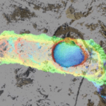
Tonight's the night for Episode 2 of the History Channel's fascinating adventure: Lost Gold of World War II. This episode has an added interest for the drone industry, as a drone pilot and two data scientists from leading drone firm PrecisionHawk used LiDAR-equipped drones to help find a real life treasure. "Lost Gold of World War II uncovers the quest to … [Read more...] about DRONELIFE Exclusive: Flying Drones in the Phillipines to Find Lost Gold – An Interview with PrecionHawk’s Intrepid Team
LIDAR
SETI Institute Drone Maps Iceland Lava Cave in Preparation for Mars and Moon Exploration
The SETI Institute is probably best known for its work scanning the stars for signs of extraterrestrial communications. But the organization's remit is broader than that. Its many research teams work towards a noble goal: to explore, understand, and explain the origin and nature of life in the universe. Exploring other planets isn't a task to be taken lightly. Equipment and … [Read more...] about SETI Institute Drone Maps Iceland Lava Cave in Preparation for Mars and Moon Exploration
Drones At Sea: The Highs & Lows of a Parley SnotBot Expedition
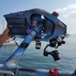
If you follow how drones are being used in the world of conservation, you will have heard about Ocean Alliance by now. The Massachusetts-based marine conservation organization has pioneered a new way of collecting biological samples from whales in the form of SnotBot. These adapted drones act as flying Petri dishes, hovering above whales as they come up to the surface to … [Read more...] about Drones At Sea: The Highs & Lows of a Parley SnotBot Expedition
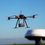
50 Ways to Love Your LiDAR: How LiDAR is Used in Commercial Drone Applications

LiDAR is one of the most important tools in the commercial drone industry. While it has been around since the 1960s when it was mounted to aircraft, its uses have expanded dramatically now that LiDAR can be used with commercial drones. What is LiDAR and how does it work? LiDAR is a remote sensing technology: sensors that are mounted to drones send a pulse from a laser … [Read more...] about 50 Ways to Love Your LiDAR: How LiDAR is Used in Commercial Drone Applications
Surveying with Drones: The Key Differences Between Aerial LiDAR and Photogrammetry
The following is a guest post from Dustin Price, licensed land surveyor and operations manager at Landpoint: a surveying, aerial data and technical services provider. There has been an influx of new and, in some cases, game-changing surveying technologies that have popped up over the past few years. Arguably the biggest of these technologies is unmanned aerial vehicles … [Read more...] about Surveying with Drones: The Key Differences Between Aerial LiDAR and Photogrammetry


