• Skip to main content
  • Skip to secondary menu
  • Skip to primary sidebar
  • Skip to secondary sidebar
  • Skip to footer
  • DroneRacingLife
  • DroneFlyers
  • Newsletter
DroneLife

DRONELIFE

Stay up to date on all the latest Drone News

  • News
  • Products
  • Industries
    • Agriculture
    • Construction
    • Delivery
    • Dual Use
    • Inspection
    • Public Safety
    • Surveying
  • Enthusiasts
  • Regulations
  • Business
  • Video
  • Podcasts

DRONELIFE Exclusive: Flying Drones in the Phillipines to Find Lost Gold – An Interview with PrecionHawk’s Intrepid Team

March 26, 2019 by Miriam McNabb 3 Comments


image: The History Channel

Tonight’s the night for Episode 2 of the History Channel’s fascinating adventure: Lost Gold of World War II.  This episode has an added interest for the drone industry, as a drone pilot and two data scientists from leading drone firm PrecisionHawk used LiDAR-equipped drones to help find a real life treasure.

“Lost Gold of World War II uncovers the quest to solve one of the last great mysteries of World War II,” says the show description.  “In 1945, as Allied forces closed in, Japanese troops commanded by the notorious Japanese General Yamashita allegedly buried a fortune in treasure in the Philippines. It’s believed the treasure included gold, jewels, and priceless artifacts stolen from many nations.”

“Now, a team of Americans follows the lead of an eyewitness who says he saw Yamashita’s forces bury countless boxes in tunnels, sealed with explosives, and riddled with booby-traps. The team must decipher a bizarre code believed to be left by a s

image: USAID

ecret society, as a means to avoid the traps and recover the treasure.”

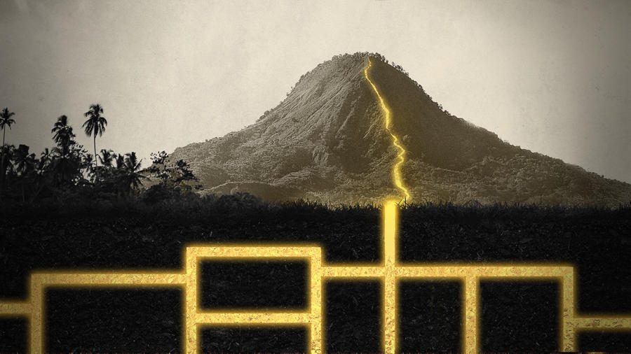
To help the team find their way through the dense rainforest, PrecisionHawk was approached by the producers.  (Jaimie Young, PrecisionHawk’s General Manager of LiDAR, is a recognized expert in the LiDAR industry and has worked on other productions.) Through the combination of air and ground sensors, including a DJI M600 equipped with a Riegl miniVUX LiDAR sensor and a Sony a6000 camera, the PrecisionHawk team produced a colorized 3D map of the forest.

DRONELIFE interviewed the PrecisionHawk group: Jaimie Young, Jill Wren (LiDAR Scientist, and PrecisionHawk’s Director of Operations, LiDAR) and Matt Tompkins, Director of LiDAR Flight Operations.  Join us for an insider look at how the 4-day mission was performed: dealing with everything from monsoon rains, an ex-special forces security team, and buffalo.

Jaimie, with more than 20 years of experience in all phases of LiDAR, was the one who was filmed; Jill did the processing and acted a flight observer; and Matt was the drone operator for the mission.

DRONELIFE (DL): How did this project differ from your usual work?

Matt: Working with the production crew, our job is more production oriented – this was more about being integrated with another team.  The conditions for flight were different because it’s a jungle – and we had to be self sufficient.  Everything we needed, we had to bring with us.  The weather was pretty interesting too, since it was monsoon season!

DL: How dangerous was this job?

Matt: The construction crew was very supportive, but we definitely tried to keep a low profile – we were careful about not being places we didn’t belong.  It also comes down to conditions: the rain made climbing up the mountain pretty tricky, and you had to wade through a waterfall to get there.  There were also caribou (buffalo) to contend with.

Jill: There were security concerns pretty much every where we went, so we had a constant escort – who was retired from the British Special Forces.  He had a whole team.

DL: What unique challenges did this work present?

Matt: By far the most challenging aspect was the terrain – it was mountainous and pretty dramatic.  It was also monsoon season – so it went from nice to torrential rain in minutes.  With no radar or weather resources, you didn’t have a lot of advance notice, so if you were in the middle of a flight you just had to bring it in.

We sourced digital elevation models that we used to follow the terrain and maintain a consistent altitude over the terrain. Jaimie ensured that they were at the correct altitude.  The canopy was very thick, and there were tall trees – we used both a digital elevation model and a visual feed.

Jill: We had a very slow internet connection, so everyone else had to get offline so that I could process.  We brought one new drone, and then discovered that we had to add worldwide GPS options to the US GPS options. 

Jaimie:  The quality of the system that we used is second to none – we were actually pleasantly surprised at what we were able to get, it did a lot better job than traditional LiDAR could have performed.  We were able to come in at different angles  – to get a higher probability of getting through the canopy.

DL: How did the producers use the 3D map?

Jill: They made a ground model and removed the vegetation – from there you will have to see how they use it!

DL: Do you see LiDAR on drones being used more in archeology?

Jaimie: Yes, the red tape to use a drone equipped with LiDAR is so much less than with an airplane – and the drone flies much closer to the ground, so it’s both more cost effective, and more accurate.  There are also the safety considerations – without a person in the aircraft, you’ve taken out a lot of risk.  

All of the team members say that despite the difficulties, filming the show was a great experience.  The one thing that they won’t tell us is whether or not the team eventually finds the gold – for that, you’ll have to stay tuned to Lost Gold of World War II.


Miriam McNabb

Miriam McNabb is the Editor-in-Chief of DRONELIFE and CEO of JobForDrones, a professional drone services marketplace, and a fascinated observer of the emerging drone industry and the regulatory environment for drones. Miriam has penned over 3,000 articles focused on the commercial drone space and is an international speaker and recognized figure in the industry.  Miriam has a degree from the University of Chicago and over 20 years of experience in high tech sales and marketing for new technologies.
For drone industry consulting or writing, Email Miriam.

TWITTER:@spaldingbarker

Subscribe to DroneLife here.

Filed Under: Featured, News Tagged With: commercial drone, Finding Lost Gold, History Channel, LIDAR, PrecisionHawk

Reader Interactions

Trackbacks

  1. PrecisionHawk Featured on History Channel’s Lost Gold of World War II | The RIEGL Newsroom says:
    November 9, 2020 at 4:36 pm

    […] Flying Drones in the Philippines to Find Lost Gold: Drone Life […]

    Reply
  2. DRONELIFE Unique: Flying Drones within the Phillipines to Discover Misplaced Gold - An Interview with PrecionHawk's Intrepid Workforce - Drone Stuff Pro says:
    March 26, 2019 at 3:44 pm

    […] Supply hyperlink […]

    Reply
  3. DRONELIFE Exclusive: Flying Drones in the Phillipines to Find Lost Gold – An Interview with PrecionHawk’s Intrepid Team | Drone Magazine says:
    March 26, 2019 at 11:14 am

    […] Source […]

    Reply

Leave a Reply Cancel reply

Your email address will not be published. Required fields are marked *

Primary Sidebar

LATEST

Ondas Unveils New Autonomous Counter-Drone and Robotic Combat Systems

MODUS and IRON WAVE aim to help military forces counter drone threats and deploy robotic systems ahead of frontline troop…

Continue Reading Ondas Unveils New Autonomous Counter-Drone and Robotic Combat Systems

Congress Introduces GUARD Act, Extending FCC Covered List Framework to Robotics

Proposed legislation would require national security review of certain foreign-made humanoid and quadruped robots A bipartisan group of lawmakers has…

Continue Reading Congress Introduces GUARD Act, Extending FCC Covered List Framework to Robotics

Blueflite Added to FAA Section 44807 Approved UAS List: Why it Matters

Cargo drone platform joins FAA-reviewed aircraft list, potentially streamlining future operator approvals Michigan-based drone manufacturer blueflite announced that its Cobalt…

Continue Reading Blueflite Added to FAA Section 44807 Approved UAS List: Why it Matters

Aeronext Unveils ActiveWing Logistics Drone Prototype for Long-Range Delivery

This article published in collaboration with JUIDA, the Japan UAS Industrial Development Association.     The Tokyo company’s new multicopter pairs…

Continue Reading Aeronext Unveils ActiveWing Logistics Drone Prototype for Long-Range Delivery

FBI, Atlanta PD Stress Need for ‘No-Drone Zone’ Compliance

By Dronelife Features Editor Jim Magill (Editor’s note: This story is part of a series of reports on efforts to…

Continue Reading FBI, Atlanta PD Stress Need for ‘No-Drone Zone’ Compliance

Building a Resilient Supply Chain: Regional Security Leaders Focus on Industrial Readiness

Northeast National Security Conference examines how the U.S. can strengthen its defense industrial base Supply chain security has become a…

Continue Reading Building a Resilient Supply Chain: Regional Security Leaders Focus on Industrial Readiness

Defense Leaders Call for Faster Paths from Innovation to the Field

Remarks at the Northeast National Security Conference highlight growing demand for rapid, commercially informed defense solutions The 2026 Northeast National…

Continue Reading Defense Leaders Call for Faster Paths from Innovation to the Field

Collective Defence Acquires Asterion in $1 Billion Deal Combining Cybersecurity and Counter-Drone Technology

Transaction creates Luxembourg’s first defense unicorn and brings together cyber defense and combat-tested counter-UAS capabilitie Collective Defence has announced its…

Continue Reading Collective Defence Acquires Asterion in $1 Billion Deal Combining Cybersecurity and Counter-Drone Technology

Vantis BVLOS System Adds New Partner, FAA Waiver Across 5,000 Square Miles

A new FAA aircraft-agnostic waiver lets Frontier Precision fly any NDAA-compliant drone under 55 pounds across more than 5,000 square…

Continue Reading Vantis BVLOS System Adds New Partner, FAA Waiver Across 5,000 Square Miles

MatrixSpace Validated in U.S. Army’s Operation Jailbreak Integration Sprint

The portable radar maker’s integration with Anduril Lattice and IBCS-M passed Army validation at Fort Carson, joining 55 companies in…

Continue Reading MatrixSpace Validated in U.S. Army’s Operation Jailbreak Integration Sprint

Secondary Sidebar

Footer

SPONSORED

Inspired Flight Gremsy IF800 VIO F1 drones geo week

What Will It Take to Strengthen U.S. Drone Manufacturing? A Conversation with Inspired Flight’s CEO

Global Mapper Mobile data collection

Collection Ground Control Points with Global Mapper Mobile

Military Drone Mapping Solutions

How SimActive’s Correlator3D™ is Revolutionizing Military Mapping: An Exclusive Interview with CEO Philippe Simard

Photogrammetry Accuracy Standards

SimActive Photogrammetry Software: Enabling Users to Meet Accuracy Standards for Over 20 Years

NACT Engineering Parrot ANAFI tether indoor shot

Smart Tether for Parrot ANAFI USA from NACT Engineering

Blue Marble, features global mapper, features Blue Marble

Check Out These New Features in Global Mapper v25 from Blue Marble

About Us | Contact Us | Advertise With Us | Write for Us | Privacy Policy | Terms of Service

The Trusted Source for the Business of Drones.

This website uses cookies and third party services. By clicking OK, you are agreeing to our privacy policy. ACCEPT

Manage consent

Privacy Overview

This website uses cookies to improve your experience while you navigate through the website. Out of these, the cookies that are categorized as necessary are stored on your browser as they are essential for the working of basic functionalities of the website. We also use third-party cookies that help us analyze and understand how you use this website. These cookies will be stored in your browser only with your consent. You also have the option to opt-out of these cookies. But opting out of some of these cookies may affect your browsing experience.
Necessary
Always Enabled
Necessary cookies are absolutely essential for the website to function properly. These cookies ensure basic functionalities and security features of the website, anonymously.
CookieDurationDescription
cookielawinfo-checkbox-analytics11 monthsThis cookie is set by GDPR Cookie Consent plugin. The cookie is used to store the user consent for the cookies in the category "Analytics".
cookielawinfo-checkbox-functional11 monthsThe cookie is set by GDPR cookie consent to record the user consent for the cookies in the category "Functional".
cookielawinfo-checkbox-necessary11 monthsThis cookie is set by GDPR Cookie Consent plugin. The cookies is used to store the user consent for the cookies in the category "Necessary".
cookielawinfo-checkbox-others11 monthsThis cookie is set by GDPR Cookie Consent plugin. The cookie is used to store the user consent for the cookies in the category "Other.
cookielawinfo-checkbox-performance11 monthsThis cookie is set by GDPR Cookie Consent plugin. The cookie is used to store the user consent for the cookies in the category "Performance".
viewed_cookie_policy11 monthsThe cookie is set by the GDPR Cookie Consent plugin and is used to store whether or not user has consented to the use of cookies. It does not store any personal data.
Functional
Functional cookies help to perform certain functionalities like sharing the content of the website on social media platforms, collect feedbacks, and other third-party features.
Performance
Performance cookies are used to understand and analyze the key performance indexes of the website which helps in delivering a better user experience for the visitors.
Analytics
Analytical cookies are used to understand how visitors interact with the website. These cookies help provide information on metrics the number of visitors, bounce rate, traffic source, etc.
Advertisement
Advertisement cookies are used to provide visitors with relevant ads and marketing campaigns. These cookies track visitors across websites and collect information to provide customized ads.
Others
Other uncategorized cookies are those that are being analyzed and have not been classified into a category as yet.
SAVE & ACCEPT