One of the largest American energy companies is looking to drone tech to improve and repair renewable energy sites. Conceived in 2014, Duke Energy’s inspection drone program now boasts more than 30 drones to inspect solar arrays and large wind turbines. Serving more than 7 million customers across the Midwest and Southeast, the North Carolina-based utility began the program … [Read more...] about Inspection Drones Illuminate Duke Energy’s World
inspection drones
What DOI Does with Hand-Me-Down Drones from DOD
The Department of Interior (DOI) is using hand-me-down drones from the Department of Defense (DOD) - and getting good value from them. The Federal Times reports that DOI’s "entire fleet of drones costs less than a single one of its manned aircraft," but they are performing dam inspections and wildlife surveys in a fraction of the time and at a fraction of the costs of … [Read more...] about What DOI Does with Hand-Me-Down Drones from DOD
After the Storm: How Drones Help in Disaster Recovery
There's no question that drones are a powerful humanitarian tool. In disasters from wildfires to hurricanes, drones can help during an event. But it may be during the long slog of recovery that drones provide the most benefit; helping people get back in their homes. During a disaster like the Houston hurricanes this year, drones proved invaluable in assessing road … [Read more...] about After the Storm: How Drones Help in Disaster Recovery
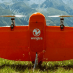
Anywhere, Anytime: Wingtra Drones Map the Alps
The WingtraOne is an unusual drone, both in looks and functionality. A VTOL (vertical takeoff and landing) design allows the WingtraOne to work in a wide variety of environments. Now xyHt reports that the Wingtra is being used to map the Alps. Swiss engineering firm Cavigelli Ingeniuere AG has been tasked with mapping Lumnezia, a Swiss Alpine valley, for the planning of a … [Read more...] about Anywhere, Anytime: Wingtra Drones Map the Alps
Australia Deploys Drones to Prevent Landslides
An Australian transportation agency is getting an assist from drone technology to predict and prevent landslides along a popular coastal area. VicRoads, a government agency in charge of roadways in the state of Victoria, uses quadcopters equipped with 3D imagery cameras to collect data, giving officials a better picture of how water drainage can be used to identify trouble … [Read more...] about Australia Deploys Drones to Prevent Landslides


