A major Kansas utility is ramping up a two-year love affair with drone technology. Westar Energy, a company serving nearly 700,000 customers in much of east and east-central Kansas, recently announced a drone program that will inspect rural power lines for breakage and damage as well as boilers. With tornadoes and ice storms ravaging the region each year, power-line … [Read more...] about Westar Energy Lights Up Inspection Drone Program
inspection drones
Philippines May Use Drones to Monitor Public Projects

Drones may soon help officials in the Philippines cut through red tape and keep public-works projects on schedule. Finance Secretary Carlos Dominguez III recently launched discussions with the Department of Public Works and Highways and the National Economic and Development Authority to investigate drone deployments that could monitor progress on public projects. An … [Read more...] about Philippines May Use Drones to Monitor Public Projects
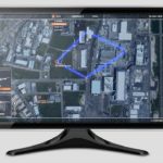
Is Sky-Futures Expanse Drone Inspection Software Good for All?

Sky-Futures cloud-based drone inspection visualization and reporting software squarely targets the asset inspection sector, but will it be broadly adopted? QuickTake THE FACTS: No one questions whether the founders of Sky-Futures know what they are doing. When it comes to drone inspections they have “been there, done that.” You can read about their history and where they … [Read more...] about Is Sky-Futures Expanse Drone Inspection Software Good for All?
Airobotics Releases New Drone Developer Software
Industrial-drone automation firm Airobotics this week launched a new software developer program the Israeli company says will allow customers to work smarter with customizable new UAV mission programs. In a press release, Airobotics states that the new program empowers third-party customers to design and develop software that can be integrated into the company’s end-to-end, … [Read more...] about Airobotics Releases New Drone Developer Software
Eos Launches Photogrammetry Suite for Drones
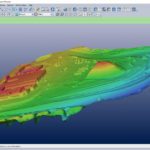
Eos Systems recently released a photogrammetry software package created specifically for drones. This past week, the Canadian firm announced the launch of PhotoModeler UAS 2016. The suite creates 3D imagery, maps and measurements from images transmitted via drone and integrates them with full geographic coordinate systems support. “Photogrammetry has been our passion for … [Read more...] about Eos Launches Photogrammetry Suite for Drones


