
Frankfurt to Host Global Leaders in Mapping, UAV Innovation, and Smart City Solutions This October by DRONELIFE Staff Writer Ian J. McNabb INTERGEO, the world’s leading trade fair for geodesy, geoinformation, and land management, recently announced that ticket sales had begun for their flagship gathering to be held this October in Frankfurt Am Main. According to the … [Read more...] about INTERGEO 2025 Opens Registration for World’s Largest Geospatial Tech Event
geospatial technology
US Army Corps of Engineers Deploys SimActive’s Correlator3D for Coastal Corridor Mapping
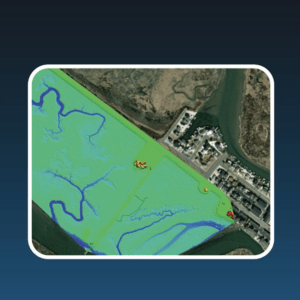
Correlator3D streamlines image processing for the Joint Airborne Lidar Bathymetry Technical Center of Expertise, enhancing topo-bathy lidar mapping efficiency. by DRONELIFE Staff Writer Ian J. McNabb SimActive Inc. recently announced that their Correlator3D product was deployed by the US Army Corps of Engineers for corridor mapping. The software is used to … [Read more...] about US Army Corps of Engineers Deploys SimActive’s Correlator3D for Coastal Corridor Mapping
Esri Integrates Blue UAS Cleared Drone with ArcGIS Flight
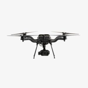
Freefly Systems' Astro Max Becomes First NDAA-Compliant Drone in Esri's Geospatial Application Esri has announced support for the Astro Max drone in its ArcGIS Flight application. The Astro Max, developed by Freefly Systems, is the first Blue UAS cleared and NDAA-compliant drone to integrate with the geospatial software1. Enhanced Capabilities for Government and Enterprise … [Read more...] about Esri Integrates Blue UAS Cleared Drone with ArcGIS Flight
GeoCue Expands TrueView Lineup with TV1 and TV1 Lite: Affordable, High-Performance LiDAR for Drone Surveys

New survey-grade sensors offer precision mapping at accessible price points, bringing professional LiDAR technology to a wider audience. by DRONELIFE Staff Writer Ian J. McNabb Alabama-based LiDAR (Light Detection and Ranging) technology developer GeoCue announced their newest additions to their TrueView lineup of sensors- the TV1 and the TV1 Lite. These new, survey-grade … [Read more...] about GeoCue Expands TrueView Lineup with TV1 and TV1 Lite: Affordable, High-Performance LiDAR for Drone Surveys
Wingcopter Expands into Long-Range LiDAR Surveying
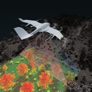
New Application Enables Efficient Infrastructure and Terrain Mapping Wingcopter has announced an expansion of its offerings to include long-range beyond visual line of sight (BVLOS) LiDAR surveying solutions. The Wingcopter 198, the company’s flagship drone, will be equipped with advanced laser scanning and camera systems to enable rapid, high-quality data … [Read more...] about Wingcopter Expands into Long-Range LiDAR Surveying


